Wind Field Modifications in Habitable Urban Areas
Seemi Ahmed1 * and Alka Bharat1
DOI: http://dx.doi.org/10.12944/CWE.7.2.11
Copy the following to cite this article:
Ahmed S, Bharat A. Wind Field Modifications in Habitable Urban Areas. Curr World Environ 2012;7(2):267-273 DOI:http://dx.doi.org/10.12944/CWE.7.2.11
Copy the following to cite this URL:
Ahmed S, Bharat A. Wind Field Modifications in Habitable Urban Areas. Curr World Environ 2012;7(2):267-273. Available from: http://www.cwejournal.org/?p=2854
Download article (pdf)
Citation Manager
Publish History
Select type of program for download
| Endnote EndNote format (Mac & Win) | |
| Reference Manager Ris format (Win only) | |
| Procite Ris format (Win only) | |
| Medlars Format | |
| RefWorks Format RefWorks format (Mac & Win) | |
| BibTex Format BibTex format (Mac & Win) |
Article Publishing History
| Received: | 2012-07-12 |
|---|---|
| Accepted: | 2012-09-17 |
Urban areas and inhabitants of cities tend to increase. Nowadays, about half of the world total population live in urban settlements. This large number of dwellers produce variety of activities and modify urban air quality and pattern.Urban wind flow is driven by a deep, stratified urban boundary layer with significant wind fluctuations. Solar heating effects include shadows from buildings and trees, aerodynamic drag, heat exchange affected by the surface property variations and turbulent heat transport.
Causes of Wind Field Modifications in Urban Areas
In urban areas, main air flows from prevailing winds are strongly modified, depending on constructions’ morphology and urban microclimate effects.3 Wind field modifications have become particularly significant because of the increasing number of high-rise buildings, industrial and vehicular activities etc. Significant differences can be found in wind speed frequency distributions at vertical levels in urban areas due to following elements and phenomenon.
- Buildings, Vegetation ( Physical and thermal Obstacles/ Roughness)
- Air conditioners (thermal)
- Natural Topography (moisture properties of the surface, undulations etc)
- Street canal effectsdue to Vehicular movements. (thermal)
- Tall buildings - Turbulence, Roughness
- Local Climatic conditions/ Seasonal Variations
- Shelter from nearby buildings,
- Urban Heat Island Effect (UHI)
Wind Field Modifications Due to UHI Effect
Urban surfaces act as a giant reservoir of heat energy. Concrete can hold roughly 2,000 times as much heat as an equivalent volume of air.
The large daytime surface temperature within the UHI is easily seen via thermal remote sensing. At night time an inversion layer is formed This traps urban air near the surface, and keeping surface air warm from the still-warm urban surfaces, forming the nighttime warmer air temperatures within the UHI. Lose of heat at night is blocked by the buildings in an urban area.
Difficulties and Peculiarities of an Urban Wind Regime Urban Roughness
Prediction of the wind speed in the built environment is difficult. One of the reasons is“surface roughness”. The many obstacles and different heights of buildings give the builtenvironment a high roughness coefficient,2 compared to open, rural locations. Theroughness coefficient is generally used to extrapolate wind speed at different heights frommeasurement at only one or two heights and locations. A high roughness coefficient meansslower acceleration of speed as height increases and therefore lower energy yields.
Table 1a gives the roughness coefficient (or length) generally used for a type of surface. It isworth noting the difference between open agricultural area (even with some houses andhedgerows) at 0.055 to 0.1 roughness, compared to 0.8 for larger cities with tall buildings –which are typical of the locations now being considered for small wind installations.
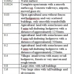 |
Table 1(a): Roughness coefficients for different surfaces2 Click here to View table |
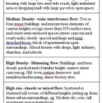 |
Table 1(b): Urban Building Roughness – Flow Regime Click here to View table |
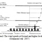 |
Figure 1: The wind speeds at Ground and higher levels (Grimmond et al., 2007) Click here to View figure |
Due to the high roughness in the built environment, the wind speed close to the groundbecomes a local parameter (dependent on local conditions near the ground). It is then notpossible to measure a local parameter (wind speed) on the basis of some averagecharacteristics of the roughness of the broader area of the built environment.
Turbulence
The roughness of the earth's surface, which causes drag on the wind, converts some of the wind's energy into mechanical turbulence. Since the turbulence is generated at the surface, the surface wind speed is much less than the wind speeds at higher levelsfigure.1. Turbulence includes vertical as well as horizontal air movement and hence the effect of the surface frictional drag is propagated upwards. The mechanical turbulence and the effect of frictional drag gradually decrease with height and at the "gradient" level (around 1000 to 2000 feet) the frictional effect is negligible. The pressure gradient at this level is balanced by the Coriolis force (and possibly the centrifugal force), and the wind blows almost parallel to the isobars
Wind Assessment and Planning Controls
The development of appropriate planning guidelines is an important step in avoiding adverse wind environments in urban areas. Currently there are a diverse range of wind assessment criteria like placing and spacing of buildings on site. Most of these are effective in general agreement with each other and with field observations. Other criteria tend to be either unnecessarily stringent or slightly lenient. In the case of former, this is also undesirable as it will present unnecessary restrictions to the form and appearance of a building. The use of wind tunnel testing remains the most reliable technique to model the wind environment effects around buildings in urban and suburban environments.. The use of Computation Fluid Dynamics (CFD) or wind tunnel visualisation techniques such as the scouring technique may be useful only as form of initial qualitative assessment and should not be solely relied upon.
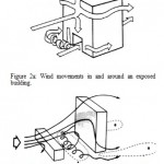 |
Figure 2(a): Wind movements in and around an exposed building: Fig. 2(b): Flow patterns around tall, slab-like building. areas of increased wind speeds at pedestrian level Click here to View figure |
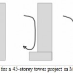 |
Figure 3: Is for a 45-storey tower project in Melbourne Click here to View figure |
Planning Controls Care should be taken in the formulation of planning controls such that the requirements are not overly restrict innovative design. Features such as aerodynamic tower forms, adequate podiums, provision of awnings, strategic planting should be encouraged but not mandatory. At the same time, controls should be provided with regards to adequate modelling of the wind effects.
The most critical areas around an exposed building are usually the areas near the corners at the base of the building (side-stream effects), at the base of a wide face of the exposed building (downwash effect, which is applicable for buildings more than 12 levels in height) and though arcades or openings at the base of the building that are open to opposite aspects of the base of the tall building (gap effect). The extent of each will depend on the level of exposure, the strength and directionality of the wind climate and the shielding or funneling effects from the surrounding buildings. Other aspects that need to be investigated are the wind conditions like turbulent wind, funneling effect of wind in any planned outdoor areas within or adjacent to the proposed development.
Urban Wind Environment Criteria
If a low building is located in the wind shadow of a tall building fig. 3b., the increase in height of a obstructing block will increase the air flow through the low building in a direction opposite to that of the wind. The lower wing of a large vortex would pass through the building.
It is has been established experimentally that wind comfort is more closely related to the gust wind speeds rather than the mean wind speeds.1 This is particularly so in the case of extreme winds which can lead to people losing balance in the wind. Rofail (2005) proposed a set of criteria that converts the mean comfort criteria into a set of criteria for maximum gusts, or peak wind speeds. However, this set of criteria is based on an assumption of 15% turbulence intensity, which in the vast majority of cases is very conservative. An alternative set of peak wind speed criteria has been proposed by Rofail (2007). The average airflow, the dynamic fluctuations, and the building scale turbulence are all closely coupled to the complicated geometry of the building.An equally valid approach would be to compare the mean wind speed criteria such as those by Davenport5 against a Gust-Equivalent Mean (the maximum of either the mean or the gust wind speed divided by a gust factor). In addition to comfort criteria there is a safety limit that is applicable to all accessible outdoor areas regardless of type or frequency of use. The safety limit suggested by Melbourne (1978) of 23m/s for annual maximum1 gust has been adopted by most consultants and forms part of most sets of criteria. Requirements for Reliable Wind Tunnel Tests The key factors that ensure a reliable set of wind speed measurements in the wind tunnel are:
- The scale model of the building and surrounds,
- The modelling of the behaviour of the approach wind and
- The sampling parameters and type of instruments that are used to measure the wind speeds.
Main Factors for Wind Modelling
These three factors are Comparison of Various Mean and Gust Wind Environment Criteria, assuming 15% turbulence and a Gust Factor of 1.5. Wind tunnel model scales should not be less than 1:500m in scale.
- The model must include the effect of the surrounds, including the local land topography. The study building(s) as well as the buildings in the immediate vicinity need to be modelled to a greater accuracy. The proximity model should extend to a radius of at least 400m. Care should be taken in modelling of porous elements such as trees, louvres or porous screens to ensure the same aerodynamic properties such as Reynold’s Number similarity. To achieve this, it may be necessary to distortion of the model’s geometry. The modelling of features such as balustrades in balconies may over-constrict the flow through these areas in the model scale and require special treatment. Similarly the modelling of gaps through a building may need to be distorted to achieve similarity in the flow regime between model-scale and full-scale.4
- The key parameter in modelling the behaviour of the approach wind is to ensure that the flow correctly matches with the full-scale in terms of the variation of the mean wind speed as well as the turbulence intensity with height to within 10 percent. The other parameter is the modelling of the integral length scale of turbulence to within a factor of 3 (AWES, 2002). The reference wind speeds need to be based on an analysis of the wind climate data obtained from an observation station located within a reasonable distance from the study site. It is recommended that the climate data used of wind speeds for a period of at least 10years.7 The wind climate data should be properly corrected for the effect of upstream terrain, shielding effects and the effect of the local land topography.7
- Measurements should be made of the peak and mean wind speeds. Filtering of the velocity signal needs to be applied for the maximum gust to represent a 3-second peak. Measurements should be taken from at least 8 wind directions, although 16 wind directions is currently the standard practice and is recommended. There are two types of instruments that can be used, hot-wire anemometry and pressure-based sensors such as the Irwin probe7. Note that some types of pressure based sensors are very sensitive to wind direction and should be avoided. Pressure based sensors should be properly calibrated to ensure that they provide a reliable wind speed estimate for the range of wind speeds within which they operate in the wind tunnel. The results should be expressed as either gust wind speeds or both gust and gust-equivalent mean wind speeds.The gust-equivalent mean is defined as the maximum between the mean and a gust-equivalent mean wind speed.
The latter is the gust wind speed divided by an appropriate gust factor. Initial tests should be carried out without the effect of vegetation to enable the wind engineering consultant to properly identify the prevailing wind flow mechanisms. It is also important to ensure that any recommendation suggested in the report shall be adequately modelled and tested in the wind tunnel. This is important since a solution that would work for one project may not necessarily be sufficiently effective for another project even if the wind flow mechanism is similar.
Case Studies
To ensure a viable Design, the formulation of strategies needs to be carried out in close collaboration with the architect or designer responsible for the project. Below are some examples of wind effects from projects undertaken by Wind-tech Consultants and details of solutions that were recommended after confirmation of their effectiveness through wind tunnel testing. Note that in some cases, more than one solution may be presented.
Case Study 1
The tower illustrated in Figure 3 is for a 45-storey tower project in Melbourne.
The tower is located at a corner of a city block and the wide face fronts a narrow street as well as the prevailing wind direction for Melbourne (north). Furthermore, the site is relatively exposed in that direction. The result is that the tower can potentially generate a significant downwash and side-stream effect around the corner of that city block. Figure 6 shows a side profile of the tower with the wind incident from the north direction. Two options were presented. One required the tower to be set back from the lane. The second treatment required a small podium with a high wall to capture the down-washed winds and direct them to a permeable carparking level.
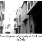 |
Figure 4: Redevelopment of property at Civil Lines, located in Delhi Click here to View figure |
Case Study 2
The development shown in Figure 4 is located in Delhi. This development is exposed to all 3 prevailing wind directions for Delhi.6
The north-easterly winds and westerly winds were of particular concern for this development as the two towers are aligned in the north-south direction. This particular site happens to be situated near the top of a ridgeline in the land form that runs north-south. This results in potentially strong funneling effects between the two tower buildings that are well in excess of the safety limit. A number of treatment options were investigated including large canopies along the entire length of the two tower buildings and over the gap. This is possibly due to the significant contribution from the upwash of the ground level winds over the northern edge of the podium. This effect seems to have been accentuated in case by the fact that the site is situated at the apex of a saddle formation in the landform, being exposed to the north-east winds along the wide aspect. The only treatment that worked effectively was the least expensive.
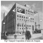 |
Figure 5: Transport Corporation of India Ltd, Gurgaon Click here to View figure |
Case study 3
Transport Corporation of India Ltd, Gurgaon- Inward-looking compact form, with controlled exposure.
Two types of windows designed: peep windows for possible cross-ventilation and view, the other being for day-lighting. The courts towards which the building has more transparency have structural framework to provide support for shading screens. Landscaping acts as a climate modifier. The window reveals of the peep window cut out summer sun and letin winter sun. Adjustable Venetian blinds in double window sandwich to cut of insulation and allow daylight. Polyurethane board insulation on wall and roof. Fountain court with water columns as environment moderator. Building systems designed so as to draw upon external environment to supplement the air-conditioning system. Eco-friendly absorption technology adopted for air-conditioning. Careful planning of air distribution system. Air-conditioning standards set by acceptance level of office staff andnot by international norms. Energy-efficient lighting system and daylight integration with controls. Optimization of structure and reduction of embodied energy by use of less energy-intensive materials6
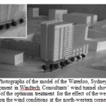 |
Figure 6: Photographs of the model of the Waterloo, Sydney development in Windtech Consultants’ wind tunnel showing details of the optimum treatment for the effect of the westerly winds on the wind conditions at the north-western corner 1 Click here to View figure |
Case Study 4
Another example is a development in Waterloo, Sydney fig.6. The results indicate that this development will be subject to un-favourable wind conditions due to the effect of the westerly winds.
It was established that this is due to a combination of direct ground level winds as well as a side-stream effect that was accentuated by the effect of the proposed high colonnade at the north-west corner of the proposed building. This effect is further complicated by the fact that an outdoor café is proposed under the high colonnade at that corner of the building. The optimum solution involved the use of strategic tree planting along the western aspect of the development as well as a free-standing canopy under the north-western corner of the colonnade area to act a deflector. With this treatment the wind conditions were improved from exceeding the safety limit to being acceptable for seating and therefore acceptable for use as an outdoor café area.
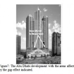 |
Figure 7: The Abu Dhabi development with the areas affected by the gap effect indicated Click here to View figure |
Case Study 5
A wind environment study was conducted for the project in Abu Dhabi described in Figure 7. This development includes 3 linked residential tower buildings with two 9-level high undercroft areas located below the linkages.
A wind tunnel model study was carried out and indicated that a significant speed up effect occurs within these gaps due to the gap effect. For each gap, the effect was successfully ameliorated by means of a baffle screen located at each end of the gap.
One of these screens served as a wall for a covered gazebo.Other areas that required treatment included one of the street corners and the base of one of the towers. The wind effects there were successfully ameliorated by means of strategic planting. Figure 7: The Abu Dhabi development with the areas affected by the gap effect indicated.
Conclusion
This paper demonstrates how it is possible to plan for habitable wind environments, while still accommodating the architectural intent.The average airflow, the dynamic fluctuations, and the building scale turbulence are all closely related to the complicated geometry of the building. Features such as aerodynamic building forms, adequate podiums, provision of awnings, strategic planting should be encouraged in the design.
With the proper modeling and simulation techniques and appropriate wind field study. It is possible to achieve a favourable outcome for both the owners and end users. Local authorities can also have a role in stipulating development controls without over-specifying the building form, which runs the risk of stifling innovation.
References
- Ahmed SirajWind Energy Theory and Practice, PHI Publication first edition2010
- BorisJay P.Dust in the Wind: Challenges for Urban Aerodynamics,, Laboratory for Computational Physics and Fluid Dynamics 2002
- Campbell Neil et. al “Wind Energy For The Built Environment” Paper published in Procs. European Wind Energy Conference & Exhibition, Copenhagen, 2-6 July 2001
- Davenport, A.G. An approach to human comfort criteria for environmental conditions, Colloquium on Building Climatology, (1972).
- Rafail, Tony “Developing habitable Built Environment” CUTBH 8th World Congress 2008.
- Representative designs of energy-efficient buildings in India Published by Tata Energy Research Institute 2001
- Urban Wind Assessment in UK, An introduction to wind resource assessment in the urban environment, Feb 2007


