Phytosociological study of vegetation of some selected arid region of the Thar desert of Rajasthan, India
K.K. Sharma1 * and A.K. Pandey1
http://dx.doi.org/10.12944/CWE.5.1.07
The present paper deals with phytosociological study in the sandy plains of the Thar Desert of Rajasthan. Panchpadra, Balotra and Nakoda of Barmer district of Rajasthan represent some unique semi-arid and arid vegetation characteristic. Barmer lies in the southern part of North-west Rajasthan. Barmer district is situated at 710 35’ 49.59" E longitude and 260 13’ 51.48" N latitude. The entire region of Barmer district is hot and sandy. Generally the vegetation in this arid region is sparse. Mainly xerophytic adapted plants are able to establish themselves in this region. The IVI value of tree species varied from 10.30 to 24.32. Variations are observed in vegetation characteristics in the three sites studied. Contagious and random distribution is recorded at all the sites but regular distribution is found only in Balotra area. The study may be used for restoration of natural vegetation in such a desert ecosystem.
Copy the following to cite this article:
Sharma K. K, Pandey A. K. Phytosociological study of vegetation of some selected arid region of the Thar desert of Rajasthan, India. Curr World Environ 2010;5(1):51-58 DOI:http://dx.doi.org/10.12944/CWE.5.1.07
Copy the following to cite this URL:
Sharma K. K, Pandey A. K. Phytosociological study of vegetation of some selected arid region of the Thar desert of Rajasthan, India. Curr World Environ 2010;5(1):51-58. Available from: http://www.cwejournal.org/?p=1098
Download article (pdf)
Citation Manager
Publish History
Introduction
Phytosociology is a qualitative study of the structure of the vegetation of a particular area emphasizing quantitative relationship of a few dominant species which control the community and there by the occurrence of a large number of rare specie. From the terrestrial ecology point of view the vegetation is an important parameter which gives an insight of the status of Ecosystem. Therefore, vegetation pattern has been considered as very significant parameter of assessment of an ecosystem. In view of the ecological significance of such studies, phytosociological analysis of several Indian forest and grasslands have been carried out from different parts of India such as Gujarat ( Shah et al. 1979; Yadav 1979; Shah and Bhatt 1980); Maharasthra (Jadav and Yadav 2004). Sharma and Upadhyaya (2002) carried out phytosociological study from a forestry arboretum and an unprotected sites of Jaipur, Rajasthan. Very little is known about the phytosociological study from the western part of Rajasthan characterized by the famous Thar desert.
The Thar Desert lies between 240 to 280 N latitude and 680 to 710 E longitude occupying an area about 35,126 km2. Mostly part of this Thar Desert lies in the state of Rajasthan but physically the desert stretches over the eastern district of the Sindh province. Dry hot summers and pleasant dry winters are a prominent feature of the Thar Desert. The mean daily maximum temperature in summer ranges from 400 C to 480 C. It reaches up to 510 C during the hot summer noon. Rainfall is sparse, ranging from 120 mm to 230 mm annually. For the last couple of years the area received no uniform rainfall. This depleted the drinking water resources. The topography of the Thar Desert is distinctly marked with sand and scattered rocky, steep slopes and vast low-lying areas locally known as patt. The accumulation of sand masses in the form sand dunes. Topography and climate factors play a significant role in determining the types of vegetation.
The north-west part of the Rajasthan is covered by about a 25000 sq km area. It includes the arid and semi-arid tracts of the districts of Jodhpur, Barmer and Jaisalmer area. It is also known as an important geographical part of the Thar desert. The Barmer district is situated in the southern part of north-west Rajasthan. Most of the area consists of dry undulating plains of hardened sand and the remaining region in largely a rolling plain of loose sand, forming shifting sand dunes varying in size and length. According to Misra (1973) India measuring 3,29 million ha (mha), out of which 150 mha is uncultivated and 90 mha is categorized as saline and alkaline. The area under present investigation is a part of “desert” popuraly known as “maroosthali”. The entire region of Barmer district is hot and sandy. Generally, the vegetation in the arid region is sparse. Only xerophytic adapted plants are able to establish themselves. Mostly the vegetation consists of stunted, thorny, or prickly shrubs and perennial herbs which are capable of drought resistance. In semi-arid regions the vegetation mainly consist of dwarf grasses, stunted growing trees, interspersed with few characteristics desert shrubs. Permanent vegetation of the entire area is xerophytic in nature.
The present study is an attempt to record and compare the diversity status and general community attributes in some selected natural and desert area of Barmer district. The main emphasis was to examine how species diversity, demography of different life forms (eg. trees, shrubs, herbs and weeds) exist in this region. The soil characteristics were also studied from this different natural desert environment because it influences micro climatic conditions, community composition and edaphic factors. This is important because such information may be useful for formulating conservation strategy for floral diversity and also for some native faunal species which are dependent on the type of vegetations and edaphic factors present in that area.
Study Area
Rajasthan is the largest state of Indian republic having 3, 42,274 sq km area. It extends between 250 38’ and 260 58’ N latitude and 730 54’ and 750 22’ E longitude. The Aravalli ranges running diagonally across the state bisect it into two unequal parts. The north-western region constitutes the major part of the Indian desert while the south-eastern region is a combination of semi arid and fertile land. Barmer district is situated at 710 35’ 49.59" E longitude and 260 13’ 51.48" N latitude (Fig.1) in the southern part of Rajasthan and is covered by 28,387 sq km areas. The present study was carried out in three important sites of the Thar desert of district Barmer namely Panchpadra, Balotra and Nakoda. The study area of Panchpadra is about 80 km away from Barmer city. It lies between 720 16’ 45.92" E and 260 0’ 48.31" N longitude. The other two study sites are Balotra and Nakoda. Balotra lies at 720 16’ 45.92" E and 250 52’ 58.62" N latitude and is about 30 km away from Panchpadra. Nakoda lies at 720 14’ 39.92"E and 250 48’ 53.43" N latitude.
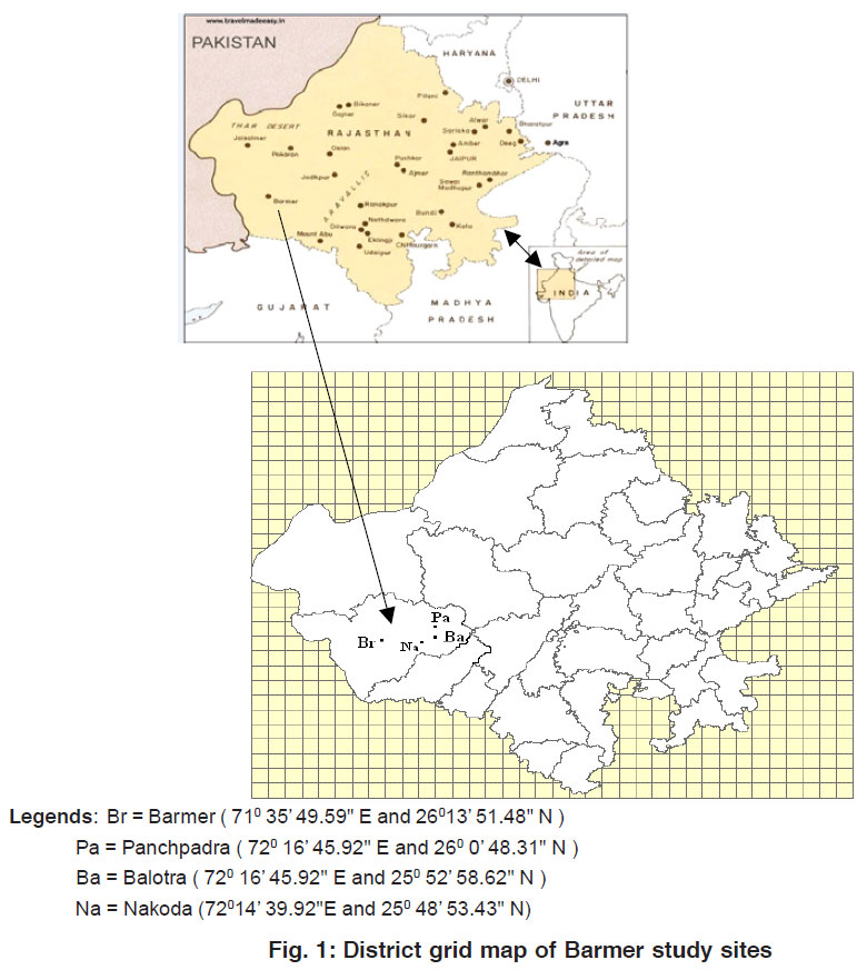 |
Figure 1: District grid map of Barmer study sites Click here to view figure |
The biogeographical characteristic of Nakoda is that the patches of stony rocky area are surrounded by light texture and loamy type of soil. It has sparse vegetation without any true forest. Rocks in the area represent various geological formations and support the vegetation. Climate of the three study sites is characterized by extremes of temperature, severe drought accompanied by high wind velocity, low relative humidity, evaporation with exceeding precipitation and less rain fall. Salt impregnated patches occur through out the area, particularly at Panchpadra in Barmer where halophytic vegetation occurs. The soil is sandy (Fig.2) with fine particles of sand and pebbles. Some physico- chemical characteristics of soil from these areas have been presented in the Table 1.
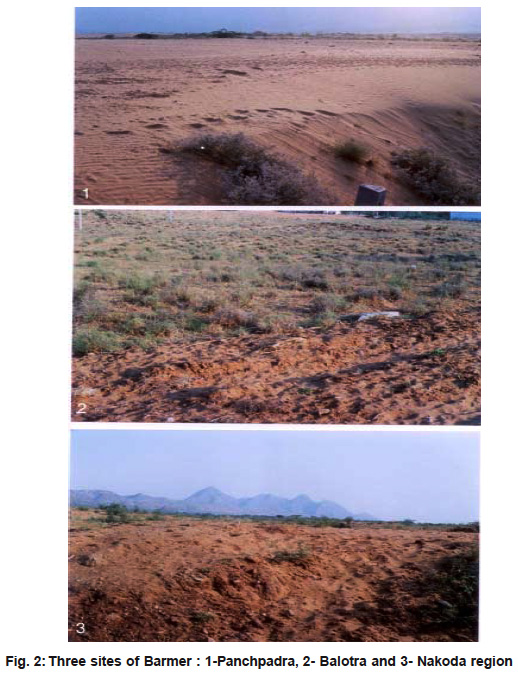 |
Figure 2: Three sites of Barmer : 1-Panchpadra, 2- Balotra and 3- Nakoda region Click here to view figure |
The characteristic diversity of plant species present in these specific study sites was the main objectives of the present study.
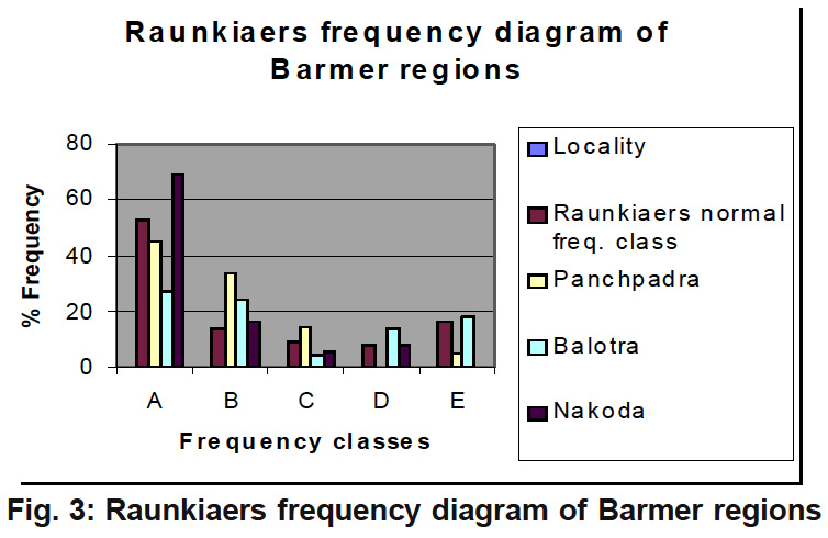 |
Figure 3: Raunkiaers frequency diagram of Barmer regions Click here to view figure |
Material and Methods
The phytosociological study was undertaken in the month of August, 2009. Total 90 quadrates measuring 1000m2 were taken from three study sites. The phytosociological attributes were estimated by setting 30 quadrates 1000m2 (100 x 100 m) at an interval of 0.5 km randomly in each of the three sites of study area. The total cover area by these quadrates was nearly 45 km in and around or nearby the study sites. Observations from each quadrate were recorded for various quantitative characteristics. Relative frequency, relative density and relative dominance were determined following the method of Phillips (1959). Importance Value Index (IVI) was calculated as the sum of relative frequency, relative density and relative dominance according to Curtis (1959). On the basis of highest IVI, sampled vegetation was delineated into different plant communities. When two or more species closely approached each other in order IVI, the community shared the names of these dominants. Species other than the dominants were classified into co-dominants, associates and rare. Concentration of dominance (Cd) was calculated according to Simpson’s method (1949).
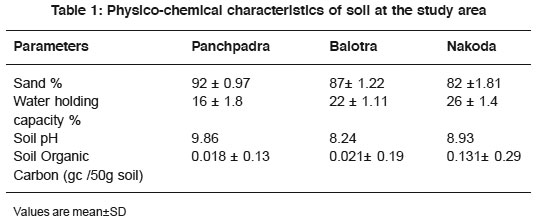 |
Table 1: Physico-chemical characteristics of soil at the study area Click here to view table |
Cd = Σ (ni / N)2
Cd = Concentration of dominance ni = IVI of individual species N = IVI of all species
The nature of the vegetation and its distribution pattern was studied following Raunkiear (1934). The law of homogeneity was expressed as A > B> C> < D = 0.05 as suggested by Cottom and Curtis (1956).
 |
Table 2: Plant species in the area IVI > IO Click here to view table |
Results and Discussion
The vegetation of tree species of the three sites of the study areas are enlisted in the Table 2.
Number of species in these sites ranged from 9-12 with maximum number in site III (Nakoda) and minimum in site I (Panchpadra).
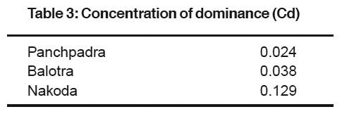 |
Table 3: Concentration of dominance (Cd) Click here to view table |
Prosopis cineraria, Prosopis chilensis, Acacia Senegal, Acacia nilotica and Tecomella undulata were common species in all the study sites. It was observed that all species were distributed contagious and randomly. A total of 9 free species were recorded in site I. The IVI value of tree species varied form a minimum of 10.32 to a maximum 24.60. Maximum IVI value was exhibited by Salvadora oleoides. It was followed by Prosopis chilensis ( 19.38) and Acacia nilotica ( 16.79). Least IVI value (10.32) was observed of Capparis decidua.
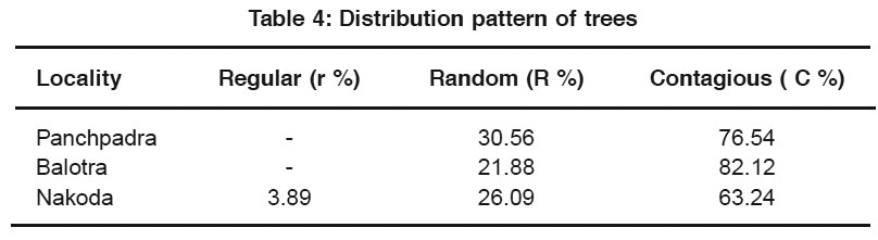 |
Table 4: Distribution pattern of trees Click here to view table |
In site II ( Balotra) a total number of 10 species were recorded. Acacia nilotica was observed to be the most dominant tree species with highest IVI of 16.81, followed by Capparis deciduas (16.71) and Prosopis chilensis ( 14.94). Tecomella undulata was observed with least IVI of 9.46. On the basis of IVI values Prosopis cineraria was found to be the most dominant species (IVI = 22.62) in the site III. The other dominant species of this site were Salvadora percica( IVI= 18.53), Balanites aegyptica ( IVI = 17.14) and Tamarix diocia ( 16.12). Acacia nilotica exhibited lowest IVI value (8.36). The study revealed of seven types of vegetational association. Prosopis and Acacia were found to be the dominant plants with other plant species. The dominancy of thorny and little leaf area species mixed with component of dry deciduous and desert forest was observed. Little variation was observed in vegetational characters from site to site. The difference can be due to variation in edaphic characteristics, microclimate and biotic influence (Rout and Gupta 1989).
The concentration of dominance was measured (Table 3) by Simpson index (Simpson 1949).
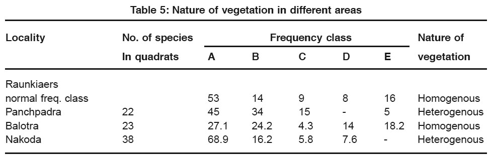 |
Table 5: Nature of vegetation in different areas Click here to view table |
It was highest (0.129) in Nakoda showing main dominance of Prosopis cineraria, Salvadora persica, Balanitis aegyptica, Tamarix dioica and Tecomela undulata. It was comparatively less in Panchpadra and Balotra. The low diversity in Panchpadra could be due to salinity in sandy soil and dry environment as suggested by Carnell and Orias (1964). It may be due to lower rate of diversification of community (Fischer 1960 and Simpson 1964).In Nakoda species composition was about 12 species. Monark (1967) reported that diversity tended to increase maximum level if the community is composed of more than 12 to 15 species. In the present study the species diversity was different in each site. Generally the contagious distribution is common in nature. Random distribution is found only in very uniform environment and Regular distribution occurs where severe competition exists between the individuals (Odum 1971). Therefore, the physiochemical nature of the environment as well as biological peculiarities of organisms themselves affects patterns of distribution. Contagious and random distribution was recorded at all the study sites (Table 4) but regular distribution was found only in Nakoda area. Contagious distribution in natural vegetation has been reported by several workers (Greig and Smith 1957; Kershau 1973; Singh and Yadava 1974).
Table 5 shows the number of species in quadrats, percentage number of species in each frequency class and comparison with Raunkiares normal frequency class. These data have also been present graphically in Figure.3. The nature of vegetation in Balotra was homogenous while in other localities it consists of heterogeneous vegetation.
It has been observed that general vegetation of Barmer area is mostly heterogeneous. The vegetation of each sites slightly differ by area wise because of change in soil strata and surrounding environment. In Panchpadra the salt is present in sandy soil. Some plants which are dominant in salty soil of Panchpadra which are not present in other two sites. Therefore, the nature of vegetation in Panchpadra is slightly halophytic. The vegetation of Nakoda is different because most part of the surrounding area is rocky hilly substratum. Balotra soil is sandy loam in nature but vegetation is slightly different as compared to that of Panchpadra but different from Nakoda. Acacia leucophloea is found in Panchpadra and Balanitis roxburghii is found in Balotra whereas Tamarix dioica, Anogeissus pendula, Anogeissus acuminata, Balanites aegyptiaca and Ficus religiosa are found only in Nakoda. Random and contagious distribution pattern is observed for the tree species as shown in table 4. It is concluded that plant species like Prosopis cineraria, Acacia nilotica, Acacia Senegal, Tecomella undulata and Prosopis chilensis are found in normal dispersal while the other plants are distributed as per the climatic conditions and their adaptability according to the area . The study may be used to restore natural vegetation in this type of desert ecosystem.
Acknowledgements
The authors are thankful to the Department of Science and Technology, New Delhi for financial assistance.
References
- Curtis, J.T. and Cottom,G.. Plant Ecology Work Book. Laboratory field and reference manual. Burges Publishers. (Minnesota Co.) (1956) 193
- Curtis, J.T.. Thevegetation of Winconsin. An ordination of plant communities, University of Winconsin press, Madison, Winconsin. (1959).
- Carnell, J.H. and Orias, E. The Ecological regulation of species diversity Amer. Nature. (1964) 48: 144-399.
- Fischer, A.G.. Latitudinal variation in organic diversity. Evol. (1960) 14: 64-81.
- Greig and Smith, P.. Quantitative plant ecology ( London). Butterworth. (1957).
- Jadhav, J.T. and Yadav,S.S. Phytosociological studies on the vegetation of Trimbakeshwar, Vani and Saptashringi forests of Nashik district, Maharashtra, Maturity Indes. Journal of Eco. Env. and Cons. (2004) 10(1): 87-90.
- Kershaw, K.A. Quantitative and dynamic plant ecology, Edward Arnold Ltd. London. (1973) 308.
- Monark, C.D. Tree species diversity in the eastern deciduous forest with particular references to north central Florida. Amer. Nature. (1967) 101: 173-187.
- Misra, R. Ecology Work Book. Oxford and IBH Publishing Co., New Delhi. (1973).
- Odum, E.P.. Fundamental of Ecology. W.B. Saunders Co. Philadelphia .(1971).
- Phillips, E.A. Methods of vegetation study. A Holtdryden Bark, Henery Holt and Co.Inc. (1959).
- Raunkiaer, C. The Life Forms of Plants and Statistical Plant Geography: The collected papers of C. Raunkiaer. Clarendon Press, Oxford , England. (1934).
- Rout, S.K. and Gupta, S.R. Analysis of forest vegetation of Morni hills in north east Haryana. Proc. Indian. Acad. Sci. (Plant Sci.), (1989) 99(2): 117-125.
- Simpson, E.H.. Measurement of diversity. Nature(London), (1949) 163: 688.
- Simpson, G.S.. Species diversity of North American recent mammals. Systzool. (1964) 13: 57-73.
- Singh,J.S. and Yadava, P.S. Seasonal variation in composition plant biomass and net primary productivity of a Tropical grass lend at Kurushetrsa. India Ecological monograph. (1974) 44: 351-375.
- Shah,G.L., Yadav, S.S. and Parabia,M.H. Phytosociological studies on the vegetation of Chhotaudepur forest division, Eastern Gujarat. J.Indian Forestry. (1979) 1: 312-318.
- Shah, G.L. and Bhatt, R.G. Phytosociological studies of the forests of Panchamahals district in eastern Gujrat, J. Indian Forestry. (1980) 3(1): 47-53.
- Sharma,K.P. and Upadhyaya, B.P. Phytosociology, primary production and nutrient retention in herbaceous vegetation of the forestry arboretum on the Aravalli hills at Jaipur. Tropical Ecology. (2002) 43(2): 325-335.
- Tiwari, A and Thakur, S. Phytosociological studies of chlorophytum tuberosum and associated plants in the forests of Madhu, M.P., Journal of Nat. Environment and Pollution Technology., (2007) 6(2): 229-233.
- Yadav, S.S. A contribution to the floristic and phytosociology of some parts of South Gujrat, Ph.D. Thesis. Part-II. Sardar Patel University, Vallabha, Vidhyanagar.(1979).


