Application of groundwater model in coastal aquifer: A case study of Veraval area of Gujarat
S. Shoba1 * , P. S. Niranjan1 and Marutheesha Reddy1
1
Faculty of Civil Engineering,
MVJ College of Engineering,
Bangalore,
India
http://dx.doi.org/10.12944/CWE.5.1.13
The development and management of fresh ground water resources in coastal aquifers are seriously constrained by the presence of seawater intrusion. Seawater intrusion is a process that occurs in virtually all coastal aquifers, where they are in hydraulic continuity with seawater. This process is caused by the higher density of sea water than freshwater. Over the years, many models have been developed to represent and study the problems related to seawater intrusion. Numerical models provide effective tool to handle ground water problems. This paper presents simulation of seawater intrusion in a section of the Veraval coast of Gujarat through Saturated and Unsaturated Transport model and examines the impact of increased pumping scenarios on extent of seawater intrusion. The density driven salt-water intrusion process was simulated with the use of commercially available finite element based software, SUTRA (Saturated–Unsaturated TRAnsport). Initial and boundary conditions determined from the aerial calibration were used to evaluate steady-state, hydraulic heads. Pumping and inflow of coastal area was estimated for three different time periods using the model.
Copy the following to cite this article:
Shoba S, Niranjan P. S, Reddy M. Application of groundwater model in coastal aquifer: A case study of Veraval area of Gujarat. Curr World Environ 2010;5(1):91 -97 DOI:http://dx.doi.org/10.12944/CWE.5.1.13
Copy the following to cite this URL:
Shoba S, Niranjan P. S, Reddy M. Application of groundwater model in coastal aquifer: A case study of Veraval area of Gujarat. Curr World Environ 2010;5(1):91 -97. Available from: http://www.cwejournal.org/?p=1110
Download article (pdf)
Citation Manager
Publish History
Introduction
Salt water intrusion, or encroachment is defined by Freeze and Cherry (1979) as the migration of salt water into fresh water aquifers under the influence of ground water development. Most large sources of fresh groundwater are in close proximity to the sea, to natural bodies of saline groundwater or to salts from effluent wastes released by human activities. Saline water in aquifers may be derived from any of the following sources:
- Encroachment of seawater in coastal areas.
- Seawater that entered aquifers during past geologic time
- Salt in salt domes, thin beds, or disseminated in geologic formations.
- Water concentrated by evaporation in tidal lagoons, playas or other enclosed areas
- Return flows to streams from irrigated lands
- Human saline wastes
The problem of aquifer contamination by sea water intrusion, together with the extent and seriousness of the problem, are mainly conditioned by three factors:
- the difference between the respective densities of the fresh and salt water
- the hydrodynamic properties of the aquifer and
- the flow that the aquifer discharges into the sea
Salt-water intrusion becomes a problem in coastal areas where fresh water aquifers are hydraulically connected with seawater. The freshwater body will overlie the salt water body because the unit weight of freshwater (1g/cm³) is less than that of salt water (about 1.022 to 1.031g/cm³) .The boundary surface between both types of water is known as the saltwater-freshwater interface or the interface.
Consider the idealized leaky system as shown in Fig. 1. The aquifer is recharged by fresh water entering from the landward boundary and by leakage through the upper clay cap (aquitard) in parts where the free water table is higher than the aquifer piezometric head (before the point of the intersection, hinge point, between the free water table and the piezometric head). In some cases, the free water table may be higher than the piezometric head all over the upper clay cap, therefore the system will be recharged by the freshwater through out the entire upper boundary as well as the land side boundary. An unconfined (phreatic) aquifer will be recharged by freshwater through infiltration of precipitation. A confined aquifer will be recharged only by freshwater from the boundary at the land side.
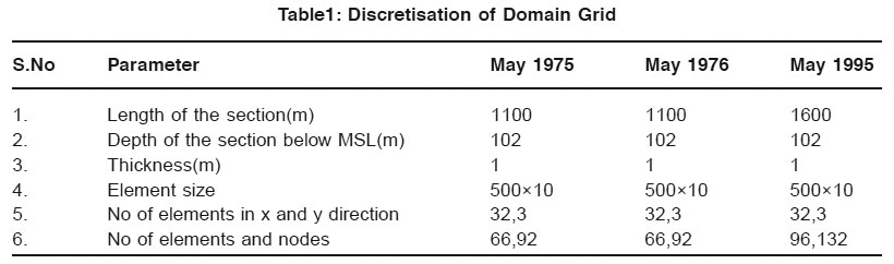 |
Table1: Discretisation of Domain Grid Click here to view table |
At the seaward boundary, there will be an influx of seawater into the system which, because of its greater density, will migrate to the bottom of the aquifer and displace freshwater. Upward leakage of mixed water will also take place through the aquitard in parts where the free water table is lower than the piezometric head (near the seaside). The rest of the mixed water will find its way out of the system through the window and the upward flux through the aquitard cause a loss of salt from the system which is replenished by new seawater moving in from the seaward boundary. The bottom boundary is impermeable. The flux of water and salt ions through this boundary is therefore equal to zero.
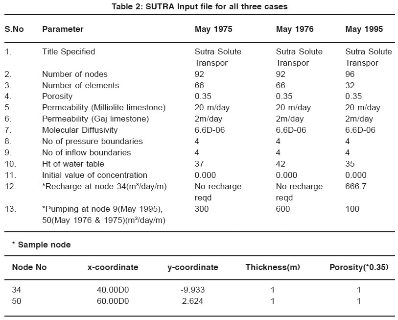 |
Table 2: SUTRA Input file for all three cases Click here to view table |
If the boundary conditions remain constant, a state of dynamic equilibrium will eventually be attained by the system. At equilibrium, the total fluid mass entering at both ends of the aquifer plus the leakage influx will be balanced by the upward leakage through the aquitard plus the flux out through the window on the sea side. Likewise, the salt mass entering at the seaward will be balanced by the salt mass swept out from the system with the mixed water through the aquitard and the window at the seaward boundary.
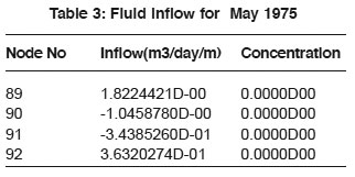 |
Table 3: Fluid inflow for May 1975 Click here to view table |
Ground Water Modelling
A ground water model is a computer-based representation of the essential features of a natural hydro geological system that uses the laws of science and mathematics. For the calculations one needs (hydrological) inputs, (hydraulic) parameters, initial and boundary conditions. The input is usually the inflow into the aquifer or the recharge, which varies in time and from place to place. The parameters usually concern the physical properties used in the model that are more or less constant with time but variable in space. Important parameters are the topography, thicknesses of soil layers and their horizontal/vertical hydraulic conductivity (permeability for water), porosity and storage coefficient, capillarity of the unsaturated zone.
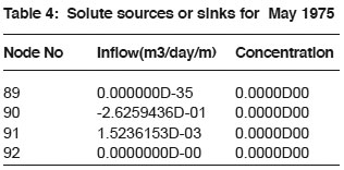 |
Table 4: Solute sources or sinks for May 1975 Click here to view table |
Sutra Model
SUTRA is a 2D ground water saturated-unsaturated transport model, a complete saltwater intrusion and energy transport model. SUTRA simulates fluid movement and transport of either energy or dissolved substances in a subsurface environment. The model employs a two dimensional hybrid finite element and integrated finite difference method to approximate the governing equations that describe two inter-depended process that are simulated:
- Fluid density dependent saturated or unsaturated ground water flow and either
a. Transport of a solute in ground water, in which the solute may be subjected to equilibrium adsorption on the porous matrix and both first-order & zero-order production or decay.
b. Transport of thermal energy in ground water solid matrix of the aquifer.
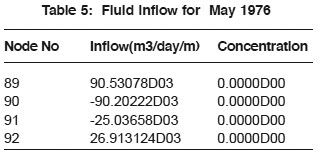 |
Table 5: Fluid inflow for May 1976 Click here to view table |
Present Study
Saurashtra is one of the important regions in West Coast of India. Due to increase in population, fast urbanization and land reforms, the district is facing a number of environment problems such as flooding, groundwater pollution due to discharge of industrial effluents, seawater intrusion etc. The chloride in observation wells that in chorwad, the Total Dissolved Solids (TDS) has increased from 3560 to 9100 ppm in seven years. In Veraval, it has increased from 2780 to 7700 ppm. The T.D.S in Kodinar has gone up from 860 to 2060 ppm in the same period. A large number of observation wells have been maintained since 1974 onwards. The T.D.S values above 1500 ppm and chloride values above 500 ppm in the groundwater are generally considered as unsuitable for irrigation and drinking purposes.
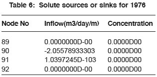 |
Table 6: Solute sources or sinks for 1976 Click here to view table |
There exists an urgent need to study systematically the causes and remedial measures for seawater intrusion. The seawater intrusion in a section of Saurashtra coast was simulated using SUTRA. The model was calibrated by varying the relevant parameters and applying appropriate boundary conditions. The latest version of SUTRA i.e. V09972D was used for the simulation. The following sections present the analysis and results. For simulation purposes, we have considered data of 3 years,
- May 1975
- Nov 1976
- May 1995.
This discretisation ensures the numerical stability and avoids improper dimensions of the elements throughout the domain. The geometric and hydraulic parameters were adopted for the database of Saurashtra Map. Along the left vertical boundary, a hydrostatic pressure defined by,
p = ρ g d ...(1)
has been imposed. Here, p is the hydrostatic pressure, ρ is the density of seawater, g is the acceleration due to gravity, and d is the depth. Therefore, the pressure at the top of this left side boundary is zero and increases linearly with depth. The finite element mesh and boundary conditions are shown in Fig.2 below.
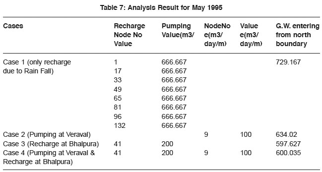 |
Table 7: Analysis Result for May 1995 Click here to view table |
Input for SUTRA Model
The domain grid has been dicretised and now the next step is to provide the input files for our analysis purpose. Two SUTRA data files are required, SUTRA Input data file and initial conditions of pressure and concentration for the simulation.
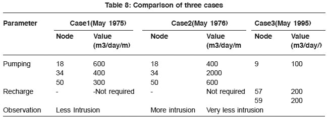 |
Table 8: Comparison of three cases Click here to view table |
Analysis of Data (Nov. 1975)
- Pumping was done at nodes 18, 34 and 50 at a rate of 600 m3/day/m, 400 m3/day/m and 300 m3/day/m respectively when 4 pressure boundaries and 4 inflow boundaries specified.
- Recharge was not required at any nodes.
The fluid inflow due to specified pressure is as follows
The solute sources or sinks due to inflows or outflows
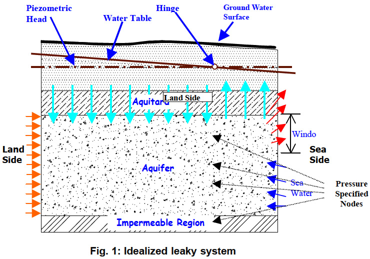 |
Figure 1: Idealized leaky system Click here to view figure |
Analysis of Data (May (1976)
- Pumping was done at nodes 18, 34 and 50 at a rate of 600 m3/day/m, 2000 m3/day/m and 600 m3/day/m respectively when 4 pressure boundaries and 4 inflow boundaries were specified.
- Recharge was not required at any nodes.
The fluid inflow due to specified pressure is as follows
The solute sources or sinks due to inflows or outflows
Compared to the first two cases, here the ingression is more. More intrusion is inferred for duration of 5 years.
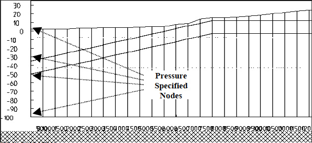 |
Figure 2: Boundary Conditions Click here to view figure |
Result for May 1995
For the first four months, recharge is provided which is 20% of 800mm i.e the average rainfall Veraval receives.
Pumping of 100 m3/day/m is done for 8 months for IRIL plant from Veraval area and the water line is plotted. It shows a decline in the water table at Veraval. Recharge of 200 m3/day/m is provided at Bhalpura village and the water line is noted.
In the last case, both scenarios of pumping of 100 m3/day/m at Veraval and recharge at Bhalpura are tried out and the water line is plotted.
Conclusion
Seawater intrusion was simulated in a part of Saurashtra coast under steady state conditions through Saturated-Unsaturated Transport (SUTRA) model. The scenarios under the three cases are discussed below:
Case 1 (May 1995)
- When recharge was provided for the first 4 months, the simulated water line was almost matching with the observed water line.
- Then, pumping of 100 m3/day/m for IRIL plant was done from Veraval. Hence, there was a decline in the simulated water line at Veraval. Very less intrusion was encountered as from the map it is clear that the water line is almost in a horizontal position.
- Further, a recharge value of 200 m3/day/m was given at Bhalpura and the increase in simulated water line due to increased pumping was noted.
- Lastly, both scenarios of pumping at Veraval and recharge at Bhalpura were tried out.
- Very less intrusion is inferred.
Case 2 (May 1976)
- This is an interesting case, where the scenarios for salinity ingress for a period of 5 years and for another 5 years were tested.
- Pumping of 400 m3/day/m, 2000 m3/m/day and 600 m3/day/m were done at nodes 18, 34 and 50 respectively.
- The salinity ingress shown from the model plot proves that more intrusion has taken.
- When the situation is continued for another 5 years, the various time steps show that at the end of 5 years, fresh water is flowing throughout the region.
Case 3 (Nov. 1975)
- Pumping was done at nodes 18, 34 and 50 and the intensity of pumping done was 600 m3/day/m, 400 m3/m/day and 300 m3/m/day respectively.
- No recharge is required
- Less intrusion is inferred.
The model is very sensitive with respect to changes in hydraulic conductivity and recharge. Higher values of hydraulic conductivity facilitate intrusion of seawater whereas increased recharge has the opposite effect, diluting saline water with the aquifer. The model is also sensitive to changes in porosity, anisotropy and dispersivity but less sensitive to changes in molecular diffusivity. The two dimensional simulation of Saurashtra aquifer with SUTRA indicated its strength in providing stable solutions with relatively long time steps.
Scope of further study
- The present study is carried out with synthetic data of pumping and recharge. The model can be developed to actually simulate the site features such as pumping, recharge from check dams, percolation wells etc. and efficacy of such artificial recharge structures can be evaluated.
- The present model considers 1-m strip of the coastal aquifer. The same SUTRA model can be applied considering its areal extent of aquifer in plan.
- Effect of industrial pollution also can be studied using SUTRA Model.
- SUTRA model can be coupled with any other optimization tool such as Genetic Algorithm, Simulated Anealing for developing decision support systems.
References
- David Keith Todd, “Groundwater Hydrology”, Iind Edition, John Wiley & Sons, (1980).
- Dipanjali.D.Bhosale and C.P.Kumar. “Simulation of sea water intrusion for Ernakulam Coast”.
- Gualbert H.P.Oude Essink, “Mathematical models and their application to salt water intrusion problems”, Netherlands Institute of Applied Geosciences.
- Henry,H.R.1964, “Effects of dispersion on Salt encroachment in coastal aquifers”. Sea water in coastal aquifers ,U.S.G.S Water supply paper 1613-C, 84 pp. H.H.Cooper, jr .,F.A.Hemry and R.E.Glover :C70-C84
- Jacob Bear and Arnold Verrujit, Modeling Groundwater Flow and Pollution, D.Reidel Publishing Company , P.O.Box 17, 3300 AA Dordrecht, Holland (1987).
- Jacques.W.Delleur, Editor-in-Chief “The handbook Of Ground water Engineering”.
- Khalid QAHMAN and Abdelkader LARABI. Simulation of sea water intrusion using SEAWAT Code in Khan-Younis area of the Gaza strip aquifer, Palestine.
- Y.Loukili, D.Esselaoui, B.EL Mansouri, Laboratoire S.I.A.N.O., University. “A numerical methodology for estimating flow, saline intrusion and contamination in coastal aquifers”, “Effect of ground water Pumping on seawater Intrusion in Coastal Aquifers”, M.M.Sherif, Civil Engineering Dept, College of Engineering, UAE and V.P.Singh, Civil and Environmental Engineering Dept, La.
- Ne-Zheng Sun , “Mathematical Modeling of ground water Pollution”, Geological Publishing House, Beijing .
- Narula, .K.K,Bansal N.K and Gossain A.K, “Hydrological Sciences and recent advances “,Indian Institute of Technology, Delhi.
- Pinder,G.F. and W.G.Gray 197.Finite Element simulation in surface and subsurface hydrology, Academic Press :295 pp
- Robert.D.Cook, David.S.Malkus, Michael. E.Plesha, “Concepts and applications of Finite Element Analysis”, John Wiley and Sons.


