Water quality evaluation of the groundwater resources in Amran basin, Yemen
Rakad Taany1 * and Abdallah Ahmed2
1
Faculty of Agricultural Technology,
Al-Balqa Applied University,
As Salt,
19117
Jordan
http://dx.doi.org/10.12944/CWE.4.1.01
This study investigates the hydrological, hydrogeological and environmental conditions in Amran basin that covers approximately 1590 km². The importance of this study is to identify the different environmental conditions associated with the socio-economic development, increase of population of Amran basin, depletion of groundwater, production of large quantity of industrial and domestic wastewater and the increase in using the fertilizer and pesticides for agriculture purposes. The socio-economic development affects badly the quality of the groundwater resources to be used directly for domestic purposes. The collected of water samples of groundwater resources analyzed for their physical, chemical and biological characteristics. According to the obtained results, some of groundwater wells are contaminated biologically by faecal coliform and chemically by high contents of salinity (calcium, bicarbonate, sulfate and nitrate). The groundwater resources in part of the study area unsuitable for irrigation purposes whereas, the water is classified as high salinity hazard with low sodium hazard (C3-S1). Also thermodynamic analyses were performed using Phreeqci software to state the capability of water resources to precipitate or to dissolve the aquifer matrix. Seventy seven percent of the water samples are free of the fecal and total coliform respectively; these percentages are mainly limited to the deep wells. Therefore about 23% of the samples are contaminated with coliform bacteria thus need treatment of disinfection and coagulation before being used for drinking.
Copy the following to cite this article:
Taany R, Said A.A.K. Water quality evaluation of the groundwater resources in Amran basin, Yemen. Curr World Environ 2009;4(1):01-07 DOI:http://dx.doi.org/10.12944/CWE.4.1.01
Copy the following to cite this URL:
Taany R, Said A.A.K. Water quality evaluation of the groundwater resources in Amran basin, Yemen. Curr World Environ 2009;4(1):01-07. Available from: http://www.cwejournal.org/?p=875
Download article (pdf)
Citation Manager
Publish History
Introduction
The water problem in Yemen reached a critical level in many water basins; in Amran basin, where (348297) inhabitants live,¹ basically on agriculture (90% of the inhabitants), the annual amounts extracted annually are about 120 million cubic meter (MCM), 85-90% of it is used for agricultural purposes, and about 10-15% is used for other purposes, where the recharge didn’t exceed 40m³, which led to a decrease in the level of groundwater. On the other hand, due to the inhabitant’s dependence on the septic tanks till a recent date, and also the human activities, specially the agricultural and industrial ones, which are exercised in Amran area, might cause the pollution to reach ground layers to the groundwater basins. This study aims to achieve the following objectives, Evaluation of the suitability of groundwater resources for different purposes (drinking and irrigation), Specification of the different pollutants, their possible sources and their actual impact on the water resources, to study the water quality of the groundwater boreholes in the area for chemical, physical, and biological constituents This should be demonstrated on a map of the location (Its location is within the UTM coordinates 1728000 and 1726000 north, 375000 and 403000 east 15° 40‘ to 16° 00 north, 43° 50‘to 44° 10‘ in the east).It is 45km in the southwest to northeast, and 10 km wide west to east, (Fig. 1). The total area of the plain is 24800 hectares and the entire catchment area of the Valley is 1280 km.² The Amran Valley forms, via wadi Attaf, part of the catchment area of wadi Karid, which is in turn a major tributary of wadi Jauf in the east.²
Material and Methods
Hydrology
The study area has a predominantly the Red sea and the Mediterranean Sea type climate. It is characterized by hot wet summers and cool dry winters,³ Temperatures exhibit large seasonal and diurnal variations. Absolute daily temperatures range from a maximum of 26.6°C to a minimum of 9.7°C. The humid wind in summer changes from north easterly and north direction. While in winter it is affected by dry wind from west and south westerly. Generally, the north easterly wind is dominant in summer and south westerly wind in winter.
The annual rainfall resulting largely from orographic effects, decreases diagonally from west south to north east; from about 321 mm at Shibam rainfall station to 255 mm at Raydah station. Cold and warm fronts steered from derision occurring over the Indian Ocean, the Red sea and the Mediterranean Sea in south westerly to nor th easterly direction, and by the or graphic effect, cause rainfall in Yemen. At the beginning of warm months, April May and sometimes October, thunderstorm precipitation might occur. The average annual temperature ranges from 9.7° C and 26.6° C reactively. The average annual relative humidity is 43.7 %. The sunshine hours are about 9.13 h/d. The average daily wind speed is 2.41 km/h while the wind direction is N.E. The main climatic parameters of Amran basin.4
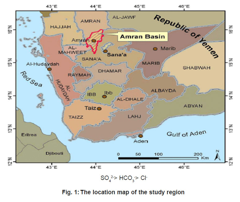 |
Figure 1: The location map of the study region Click here to view figure |
Geology and Hydrogeology
The Amran valley floor is a graben or down- faulted trough. Quaternary volcanic in the four of dark gray to black basalts up to several of meter thick flank the valley to the East and South-East. Quater nary alluvium, up to 300m thick and consisting of clay, loess, silt, sand and boulder gravel, forms the valley floor. The volcanics are interbedded with the alluvial sediments in many areas. Amran limestone underlies the alluvial in the valley sector and from the high mountainous regions to the West and North of Amran town. Although essentially a yellow-white limestone, marls and calcareous shale’s occur within the sequence classified as the Amran limestone.5
The Quater nary alluvium fo r ms the principal aquifer of the region. The groundwater in the aquifer is being replenished from the surrounding hills via numerous Wadis. Lack of krast- type solution cavities the Amran limestone means it is a relatively poor aquifer regionally, although fractured zone do occur, particularly along the flanks of the valley, renders the formation more productive in some places.6 The Quater nar y alluvium is relatively good aquifer. The highest permeabilities in which are in the gravel layers, aquifer tests were performed given the following ranges of aquifer parameters, transmissivity 860 m²/day, storage coefficient 0.0001 and hydraulic resistant 400days.7
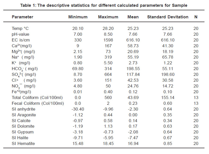 |
Table 1: The descriptive statistics for different calculated parameters for Sample Click here to view table |
Aquifer would be exhausted in year 2041 and 30 percent of the valley would have gone dry by 2011. The worse-case scenario presented by7 was that 60 percent of the wells existing in 1991 would be dry by year 2004, if the increase in depletion of aquifer storage observed between 1977 and 1999 continued at the same rate.7
Hydrochemistry
The quality of groundwater is a function of its chemical, physical and biological constituents. This study focues on the chemical properties of the different wells located in the study area. The work in the study consists of field and laboratory works as follows:
Field Work
The Fieldwo rk was restr icted to the collection of samples from the water sources for chemical and physical analyses in the field by using portable equipment. Measurements included are temperature, electrical conductivity (EC), and pH.
 |
Figure 2: Classification of the water samples for irrigation purposes Based on SAR and EC (μs/cm) Click here to view figure |
Laboratory Work
Chemical and physical analyses were performed on the collected samples to determine concentrations of: (Ca2+, Mg2+, Na+, K+, SO4 2-, Cl-, NO -, HCO -and Fe+²). The data were be interpreted and repor ted by using many programs for thermodynamic calculations and statistical and hydrochemical analyses calculations. All analyses were carried out at the Ministry of Water and Environmental (Yemen). The samples were analyzed according to the standard methods for the examination of water and wastewater.8
Results and Discussion
Most of wells in the study area, the cations, anions, total coliform and fecal coliform, The concentration is within the permissible limits for dr inking water recommended by 9,10,11, While concentrations of some elements were higher the maximum limits of drinking water recommended by WHO and standard Yemen, Table 1. Of concentration above limits in some wells according to WHO standard.
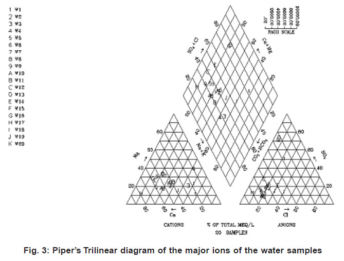 |
Figure 3: Pipers Trilinear diagram of the major ions of the water samples Click here to view figure |
Bicarbonate concentration was higher than the maximum limits of drinking water recommended by the World Meteorological Organization (WHO) but it is still within the limits of drinking water recommended by the Yemen standard.
Sulfate concentration was higher than the maximum limits of drinking water by WHO and the Yemen standard. The nitrate concentration in well 3 and 14 is 50 and 45.3 mg/L respectively, the wells lie close to a wastewater treatment plant and a agricultural activities. It is recommended by all the standards that the long-term count of the total and faecal coliform must be zero. According to this it was found the 77% of the samples are free of the fecal and total coliform, is percentage and mainly limited to the deep wells. Therefore, about 23% of the samples are contaminated with colifor m bacteria; thus, need disinfection and coagulation before being used for drinking purposes.
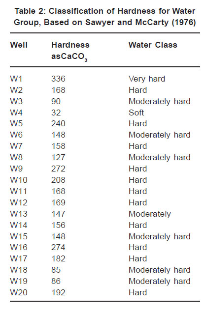 |
Table 2: Classification of Hardness for Water Group, Based on Sawyer and McCarty (1976) Click here to view table |
The water quality of the water resources depends on the intended uses, domestic, irrigation or industr y. Classification of water samples according to their total hardness:
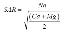
Most of the groundwater in the study area can be used for domestic purpose, the water is classified as moderate (35%) to hard (55%), according to,12 (Tables 2). The evaluation of the sodium adsorption ratio and total dissolved solids/ electrical conductivity plays a major role in the evaluation of irrigation water. The SAR calculated according to the following equation:
Most of water samples had very low EC or were non-saline. Water quality analysis showed that water can be used for use in arid region, such as the Amran Valley, where it might have a high salinity hazard, however be used occasionally on a supplemental basis with little danger to all but the most sensitive crop,13 Only two of the sampled wells (Table 3 and Figure, 2) showed water with a high salinity hazard; whereas all of analyses indicate a low sodium hazard.
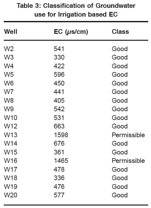 |
Table 3: Classification of Groundwater use for Irrigation based EC Click here to view table |
Based on the four main cations calcium, magnesium, sodium and potassium, and the four anions, bicarbonate, sulfate, chloride and nitrate14 proposed a Trilinear diagram that per mits the classification of the water according to15, into six types. All the groundwater samples were plotted on piper’s Trilinear Diagram. Fig.3, these water types are:
Type One
This type characterized by normal earth alkaline water with prevailing bicarbonate. This type represents around 65 % of the total samples. The majority of the samples of this water type are located around Amran town, Aljannat, Karef, Raydah and North Amran valley (Thebeen).
The chemistry of this water originates from dissolution of almost pure carbonate. This type of water is characterized by low salinity and with the following ionic order:
Ca2+> Mg2+> (Na+ + K+) HCO3 -> Cl> > SO4 2-
Type Two
This type characterized by normal earth alkaline water with prevailing bicarbonate. It is classified as NaHCO water. Only the water samples collected from Joop and Almonjedah belons to in this type of water (20%). It is characterized by the highest salinity among the other three types, and by the following ionic order:
Na+ > Ca2+> Mg2+ HCO3 - > Cl- > SO4 2-
Type Three
This type characterized by earth alkaline water with increased portion of alkalis and prevailing sulfate. Around 15% of the analyzed water samples especially those collected from the vicinity of the Amran cement plant.
This water type is characterized by low salinity and with the following ionic order:
Ca2+> Mg2+> (Na+ + K+)
References
- Ali, S.A, Groundwater of Yemen, National Water Resources Authority, Sana’a (2000).
- ARA, Guide of Agrometeorology of Yemen 1881-2004 (2005).
- Central statistical organization, Dec, final results, population, housing, establishment census (2004).
- DHV, Groundwater Resource and use in the Amran Valley “, UNDP/SSHARDA/Sana’a. Northern Region Agricultural Development project Yem/87/015 (1993).
- Jac A.M van der Gun and etc, The water resources of Yemen, a summary and digest of available information (1995).
- Langguth, H.R, Groundwater verhaltisse in Bereich del velberter stattels, Des Minister fur Ernahurung, Landwirtschaft und Forsten, NRW, Düsseldorf,(1966) 127.
- Mohammad, A.N, and Khalid, H. B. , Irrigation, Al Bsra University Ministry of Higher Education, Iraq (1980).
- M.T Jones., Appraisal of groundwater resources in the Amran region, Sana’a Governorate, Hydrogeologist/ Consultant, UTF/YEM/ 020/YEM, Technical Report (1996).
- NWRA and BGR, Delineation of Groundwater protection Zones for the Amran Municipal Wells, Technical report NO. IWRM- (2007) 07-14, Sana’a.
- NWRA, National water Resources infor mation Center, Rainfall and Meteorological (2005).
- Piper, A.M., A graphic procedure in the geochemical interpretation of water analysis, Trans. Am. Geophys (1944).
- Sawyer, C.N and McCarty, Chemistry and Sanitary Engineers, 2 nd edition. McGraw – Haill, New York (1967).
- Standard methods for examination of water and wastewater, American public Health Association. 7th edition (1992).
- Tibbitts, Jr., and James Aubel, Groundwater Resources Investigation in the Amran Valley. Yemen Arab Repaplic, U.S. Geological Survey, Reston, Virgina (1980).
- World health Organization, International Standard for drinking water (1997).


