Heat Stress Vulnerability of Populations and Role of Urban Heat Island
Manisha D Malcoti1
*
 , Hina Zia1
and Chitrarekha Kabre2
, Hina Zia1
and Chitrarekha Kabre2
1
Faculty of Architecture and Ekistics,
Jamia Millia Islamia,
New Delhi,
India
2
Department of Architecture,
School of Planning and Architecture,
New Delhi,
India
http://dx.doi.org/10.12944/CWE.18.1.25
Copy the following to cite this article:
Malcoti M. D, Zia H, Kabre C. Heat Stress Vulnerability of Populations and Role of Urban Heat Island. Curr World Environ 2023;18(1). DOI:http://dx.doi.org/10.12944/CWE.18.1.25
Copy the following to cite this URL:
Malcoti M. D, Zia H, Kabre C. Heat Stress Vulnerability of Populations and Role of Urban Heat Island. Curr World Environ 2023;18(1).
Download article (pdf)
Citation Manager
Publish History

Introduction
An estimated 600 million people (40 percent) will live in urban areas in India by 2031, and 850 million people (50 percent) will do so by 2051.1. This urbanization trend for the last years has brought challenges like an unprecedented demand for affordable housing, urban infrastructure, jobs, and essential services, including health services. The ever-increasing demand for urban land is mainly met by sacrificing the natural rural or peri-urban areas. This results in transforming natural, open spaces into vast impermeable built urban surfaces showing the relevance of a decoupling effect between population and resources 2. Not only are surfaces modified, but local climatic conditions are also moderated, where a change in air temperature is the most common noticeable phenomenon.
Also known as the urban heat island (UHI) effect, it's a process where warm pockets develop in urban neighbourhoods with air temperatures higher than the surrounding rural or sub-urban areas (Oke, 1981). With climate change implications everywhere now, urban areas may see a more intense modification in climatic conditions 3. Combine UHI with heatwave conditions, which becomes a health hazard for populations, creating severe health implications 4. Climate change will increase the risk of heat-related events, and its adverse effects on human health cannot be ignored 5,6. Summer heat waves are predicted to become more frequent and intense worldwide 7. Acting on such predictions can help prepare mitigation strategies best suited for extreme heat events causing human mortality. The 1995 Chicago heat wave that killed approximately 700 people is an example of one such occasion 8. A study in China ruled that socio-economic factors account for between 12 and 20 percent of the variability in UHI intensity. The contribution rate of the urban economic scale is often higher than that of the population and industrial structure variables. Heat stress increases throughout the hot summer due to urban economic growth 9. Another study that examines the major US cities provides a framework for evaluating the intercity and intracity dispersal of surface UHI (SUHI) intensity by race, wealth, and age. They discovered that the pattern of daytime (summer) SUHI intensity is worse for populations of colour and the underprivileged compared to the native white and economically well population in nearly all major US cities10. Another research conducted in five East African cities spread in various climate zones in 2003 and 2017 confirmed that SUHI intensities were different for various neighborhoods. Numerous urban residents, particularly those who are most sensitive during heatwave occurrences, have experienced increased heat stress as a result of the mean annual daytime SUHI intensities in most cities being more significant than the mean night-time SUHI intensities.11. It is observed that UHI studies have a great deal of relevance in the environment, urban planning, and clinical research fields 12.
Cities present a deadly combination of natural and anthropogenic factors that interact to compromise the health of urban populations 13. In exceptionally hot weather, mortality and morbidity from air pollution and infectious diseases also rise 14. It is observed that temperatures in urban centres are higher than in adjacent pockets due to the urban heat island because compact built-up areas have a higher concentration of urban surfaces and fewer green or permeable areas, even though periodic heat wave occurrences in cities increase health problems for the entire population 15. According to studies, geographical traits that ordinarily have little impact on health can readily become risk factors during some extreme weather events. Clarke16 discovered that the night-time effect of UHIs cannot be ignored during a heatwave since it exacerbates heat stress by denying urban people the cool relief found in rural areas at night. His research on the New York metropolitan area heatwave led to this discovery. Sharma et al. examined how extreme heat events are on the rise in the city and how UHI is observed to increase the quantity, intensity, frequency, and length of heat waves through research on the urban climate of Delhi7.
Through heat risk models, there have been attempts to combine risk maps, such as the UHI impact and environmental, demographic, or physical characteristics. These models aid in producing signals of risk variation within a city 17. Here we contend that there is a dearth of research in developing-world cities with dry or semi-arid climatic conditions exploring the health effects of heat-related events. Low-adaptive capacity cities may be particularly sensitive to the effects of a changing climate. The U.S. Agency for International Development (USAID) specifies that strategic urban planning can decrease heat risks by including green roofs and energy management 18. As presented in another study involving hot and dry climates, urban planning regulations are not just measures to decide on the urban form. They also significantly impact the microclimate in urban areas19. Urban green space (UGS) distribution with greater spatial equality could have a cooling effect on the city, contributing to the urban environment's sustainable growth. 4. From the planning aspect, UHI impact can be easily mitigated through urban morphology, where parameters like urban plan area density and urban geometry influence airflows outside and inside the building, thus directly affecting energy consumption20. The urban built environment impacts the surface temperature equally as the urban green areas 21. This study aims to analyze UHI's impacts on populations' heat stress vulnerability. The inability to recognize this vulnerability represents a massive public policy failure for which the administration and planners must act proactively. This paper will first present a basic understanding of UHI and the existing methods in UHI research before presenting the causes and effects of UHI. Furthermore, this summarizes its interaction with the urban population while discussing how UHI exacerbates heat stress in vulnerable populations. Lastly, the perspective of the UHI is addressed in terms of how the field of urban planning has a significant role to play in UHI mitigation.
Understanding Urban Heat Island
Climate change is causing an increased intensity of Urban Heat Islands 22. Enormous studies have been done to realize that the urban heat island effect varies with geographical locations. Analysis of a built model presented that a city's form, size, and function are significant factors affecting UHI's development and intensity 23. UHI is generally measured as Surface UHI and Atmospheric UHI, depending on the surface or air temperature. Surface urban heat island (SUHI) is the intensity measured at the urban surfaces, ground, pavements, roofs, walls etc.24. Depending on the characteristics of the surface material, its intensity changes. Based on production, observation, and influence, atmospheric UHI, where we measure air temperature, may be further explored as a canopy layer and boundary layer. According to a few studies, atmospheric urban heat islands can be low during the late morning and become more noticeable after nightfall because of the slow release of heat from urban infrastructure25,26. However, the characteristics of urban surfaces and the seasons affect the timing and duration of this peak. According to Voogt27, canopy layer urban heat islands (CLUHI) are found in the lower air people breathe and live in. It reaches the roof level of built-up areas, including trees, from a level not far off the ground. As shown in figure 1, the boundary layer urban heat island (BLUHI) begins where the cloud top urban heat island (CLUHI) ceases and extends up to the point when urban landscapes have no impact on the atmosphere. In an urban situation, this zone usually doesn't reach farther than 1.5 kilometres 26. Processes in CLUHI are on the micro or local scale and represent site-specific characteristics in contrast with BLUHI, which has processes acting on the mesoscale.
 | Figure 1: Vertical subdivision of atmosphere and urban climate scales28
|
Approaches to studying UHI
Scientists use direct and indirect methods as well as numerical and empirical models to identify and study urban heat islands 27. In addition to airborne sensors, for a decade, researchers have used remote sensing to estimate surface temperatures, and this methodology is gaining immense popularity. However, it is an indirect measurement technique. Satellite data is collected to produce thermal images. Unlike field observations, thermal remote sensing techniques can measure spatial and temporal temperature variations in urban areas 29,30. Some of the most popular approaches by researchers have been described below. Figure 2 below presents a flowchart about UHI measurement.
 | Figure 2: UHI measurements27
|
Onsite measurement approach
The on-site measurement approach involves the comparison of the rural-urban near-surface temperature using a stationary or moving station or a network of stations. These field measurement approaches also include traverse studies using moving vehicles in heterogeneous site areas to study temperature trends 31. Though it is a simple approach to studying UHI patterns, it has several limitations, including installing a network of measurement devices in a city or depending on the meteorological stations planned by the administration. For example, a study by Mohan et al. presented that the Delhi NCR in India has been witnessing a warming trend for three decades32. Their study did a temperature analysis of historical temperature data (1968-2005) provided by the Indian Meteorological Department (IMD) for four meteorological stations in the National capital region. Many studies use weather stations or meteorological instruments at specific field locations to conduct long-term or short-term studies of temperature trends 15,33,34. Using the field measurement approach using stationary and transect measurement approach, greenery infrastructure (G.I.) emerged as a key design strategy for sustainable cities and communities because it reduces urban heat islands 35. Even with data reliability, the field measurement approach is time-consuming, provided a generous amount of data is produced. Also, it has the other constraint of being expensive due to the equipment involved.
Thermal Remote sensing
With the new technological innovations, remote sensing uses sensing reflective radiations to study surface temperatures using satellites. Using software like ArcGIS, we can generate maps presenting the interrelationship between urban growth and surface temperatures 36. This approach has proved to be very beneficial in studying spatial variation in UHI of urban regions 29. Voogt and Oke (have detailed the application of remote sensing to study UHI. This strategy fails because satellite thermal sensors only measure surface temperatures based on the far-off sensor's upward heat radiation patterns..37
Small-scale modelling
Small-scale modelling can examine how a building's parameters affect its environment.38. In one such study, a simple hardware model demonstrated how urban geometry could influence the nocturnal urban heat island effect 23. While it's straightforward to replicate a simple set of the site, the main challenge is experimentally generating thermal stratification as close as actual and the disadvantage of the high cost of modelling.
Simulation Approaches
Over the past two decades, academics have made great strides in their ability to explain mathematical models for even very large locations. This is only possible due to the development of computer techniques and equations.26. The equations can be used to describe the processes which govern changes in environment such as temperature, humidity, wind velocity and pollutant concentration. These phenomenon in an urban context can be very complex to review otherwise28.
Amongst these models, the two most reliable and satisfactory approaches are energy balance models and methodological techniques based on numerical simulations of dynamical systems. These two approaches involve providing a database for the 3-D geometry of buildings and data on various environmental variables.
Energy balance model – Oke was the first to look into this method, which involves applying the principle of energy conservation to a given location to determine how much energy is transferred from one surface to another via various heat fluxes, such as those caused by the atmosphere, turbulence, and the velocity field. These simulations take a lot of time and require a lot of processing. Therefore, to ensure accurate results, researchers choose very small-time steps, which lengthen computation times but eliminate a vital benefit of this strategy.
Computational Fluid Dynamics (CFD)
Due to its simple and well-optimized modelling techniques, the computational fluid dynamics (CFD) simulation approach plays a vital part in the research 39. CFD can gather more accurate data regarding UHI distribution inside and above the building canopy than the energy balance models discussed above because it solves all of the fluid's leading equations at once within urban settings. Nevertheless, it becomes computationally and theoretically challenging to take into account intricate details in addition to the complex atmospheric dynamics of a city. The primary computing challenge is the number of control sites needed to replicate a metropolis.
Energy balance of earth
The earth's energy balance starts with the atmosphere's sun-earth relationship and radiative properties. After being reflected, absorbed and radiated from the atmosphere, the incoming energy from the sun reaches earth and follows the same energy exchange with urban surfaces24 (As explained in Fig 3); the short-wave radiations from the sun get reflected and absorbed by the atmosphere and surfaces. Some are stored as thermal energy in the surface materials. The anthropogenic heat loads and a large portion of the heat that returns to the atmosphere as long-wave radiation create a positive energy balance in these metropolitan regions resulting in the UHI effect. In simple terms, it can also be explained as a balance between incoming and outgoing energy.
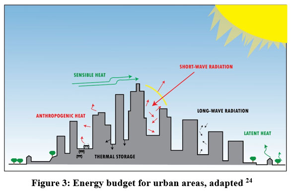 | Figure 3: Energy budget for urban areas, adapted 24
|
Oke, through his scale model of urban and rural settings, also established that, given the right circumstances, rural/urban cooling rates and the subsequent pattern of rise and fall of the heat island represented by the model closely resemble those found 23. This leads to the understanding that the urban or rural climatic effects result from landform and land use. Urbanization tends to replace open, green permeable areas with impervious manufactured materials; these urban materials have very distinctive thermal and radiative properties and are highly diverse. The urban surfaces also cause friction to the horizontal wind flow and the tall buildings along an urban canyon, creating a trap known as a radiation trap where the re-radiated, reflected heat could not escape back to the atmosphere 40. Research shows that biophysical causes of urbanization should be considered when projecting future climate change trajectories, evaluating urbanization effects and mitigating urban heat 41
Causes and Impacts of UHI
Environmental Protection Agency stresses that the effect of UHI is equal on the environment and humans. Increased air pollutants and greenhouse gas emissions cause a decline in air quality, adversely impacting human health and comfort.24. There is a negative energy loop in urban areas where the population uses more energy to counter the ill effects of high temperatures.
Various researchers have established and successfully quantified the social, economic and ecological impacts of UHI in cities 42–47. Oke, through his work models, established that urban geometry displays a crucial role in the development of UHI 15. Taha showed the effects of surface albedo, evapotranspiration, and human heating on the near-surface climate in his studies on urban climates and the causes and consequences of urban heat islands48. His research using numerical simulations and field observations suggests that reducing surface and air temperatures can effectively be accomplished by increasing albedo and vegetation cover. Their investigation of low-rise urban street canyons in the dry Negev region examined microclimatic factors and the overall energy balance49. According to their investigation, the openness or compactness of canyons or these streets directly influences the intensity of UHI, which keeps on varying throughout the day. In their study of Atlanta's residential growth patterns and urban heat island formation, Stone and Rodgers concluded that four main elements contribute to localized heat50. These factors may be summed up as
- Reduced evaporative cooling
- Minimal surface reflectivity
- Presence of vertical surfaces,
- Waste heat generation.
Further, Yamamoto summarized that in addition to anthropogenic heat and greenhouse gas release, urban areas have a UHI effect due to urban structures and urban surfaces/materials, which replaced the natural cover51. Another study of annual minimum temperature trends for NCR, India, established increasing warming trends in the nocturnal temperatures 52. Their study attributed it to land-use patterns changed over time and additional anthropogenic heat following the rapid urbanization of NCR. Another study for the same region presented that variation in land use and land cover ( LULC) due to the pressure of urbanization plays a vital role in UHI development, where a majority of permeable surfaces are being converted into impermeable surfaces 53. Numerous studies have presented that changes in LULC due to urbanization also cause surface temperatures to rise over time 29,30,54. However, land use and cover cannot be considered the sole causative factors for land surface temperature 55. The study finds that land use, which can connect biophysical processes to socio-economic activities, is more significant than land cover in the influence of urbanization on ecosystems at smaller scales. Various global studies have established the impacts of UHI on the environment through the modification of microclimatic conditions, including outdoor thermal comfort 19,56,57. Low-albedo impervious surfaces, including sidewalks, roadways, and parking lots, cover a large portion of the urban surface and contribute to UHI. Using cool pavements, such as highly reflecting and permeable pavements, in urban planning could improve urban microclimate 58. EPA lists the impacts of UHI as
- Increase in energy consumption
- High emissions of greenhouse gases and air pollutants
- Compromised human health and human thermal comfort
- Degraded water quality.
Also, elevated air temperatures increase the rate at which ozone formation happens at ground level. Yamamoto explains that urban areas are uncomfortable zones to live in depending on geographic location in summer because of higher temperatures during the daytime and an increasing number of sweltering nights. The result is an increase in demand for air conditioning, resulting in increased energy consumption which in return causes the release of photochemical oxidants. During winter, inversion layers are formed due to the radiative cooling of calm, clear cold nights and ascending air currents created by warm urban areas. Mixed layers and the development of dust domes, which worsen air pollution, are the end outcome. Urban heat islands may become more intense globally due to climate change, which could impact local air quality, heat stress, mortality, and energy demand.59
UHI and interaction with urban populations
Another essential term while understanding health effects on the urban population in changing environment is vulnerability. As per the Intergovernmental panel for climate change (IPCC) valuations, "Vulnerability is defined as the propensity or predisposition to be adversely affected by any event or person " 3. While studies present various aspects of the population's vulnerability due to biophysical components, the social vulnerability components also need emphasis. As Cutter, Boruff and Shirley put it, the Social Vulnerability Index (SoVI) used with biophysical risk data can help to put concentrated efforts of mitigation and relief to the most vulnerable groups in a city 60. Thus, SoVI can assist local decision-makers in highlighting those factors that threaten the sustainability of the community. Using this index in conjunction with the study of biophysical risk data, authorities can help mitigate efforts to target the most vulnerable groups. Recent studies show a complex but the clear connection between urban pollution, UHI, and declining human health 10,61,62.
A study in Phoenix by Jenerette et al. presented that socio-economic factors also contribute to the impact of UHI in an urban neighborhood43. The study explained that surface temperature impacts primarily through vegetation cover modifications. The research combined population and topographic data from the United States with early summer surface temperature and vegetation data acquired from satellites. The research results from London neighbourhoods provided knowledge of temperature and UHI-related effects on human health that were intended to support policy formulation to increase health benefits and reduce adverse effects63. The risk to residents (75 and older) increased as the UHI effect became more pronounced.
Even in areas where heatwaves were previously uncommon, extreme events are predicted to become more common under climate change scenarios 64. This study stresses that mitigation measures for heat stress incidents should primarily target the elderly, women, children, and those with chronic respiratory diseases. Heatwaves in areas already struggling with high temperatures make it a health hazard for populations, creating severe health implications. Empirical research from cities across the globe suggests that vulnerability to heat stress is unequal across society 12,14,45,65,66. With the evaluation of land use and socio-economic patterns, a Baltimore–D.C. metropolitan area study found that fast socio-economic development areas can easily correlate with high percentages of impervious surfaces. The impervious surface results in high mean surface temperature and high UHI intensity 67.
Further, a study evaluated the relationship between UHI and the economy at the neighbourhood scale for 25 cities worldwide 10. They came to the conclusion that impoverished communities typically endure increased heat exposure. Socially vulnerable populations in urban areas are disproportionately affected by the urban heat island effect, and rising temperatures during heat waves brought on by global climate change 61.
Heat Stress Vulnerability and role of UHI
The unequal vulnerability in the populations against any environmental factor is considered fundamentally unjust by social parameters60.Therefore, the authors need to identify heat vulnerability indicators in population arising from UHI. A section of the population is said to be vulnerable to heat when they have limited abilities to cope with or mitigate heat hazards due to social or economic reasons. "Vulnerability" is the propensity of a system or a person to be adversely affected by any hazard 3. The probability that a severe climatic event may occur and harm people, infrastructure, services, and ecosystems is another such way the IPCC defines "hazard."
The physical stress caused by heat waves on humans is called heat stress. Heat vulnerability is linked to the physical and psychological characteristics of individual persons. In India, National Disaster Management Authority (NDMA), summarizes the vital factors influencing heat vulnerability. These are the quality of the built environment, local geography, individual lifestyle, and social factors 68. The intent is to study how UHI exacerbates heat-related stress in populations. The table summarizes various global studies exploring the relationship between UHI and heat stress in urban populations and its consequences in chronological order. A deliberate effort was made to concentrate on studies that offered numerical estimates of the UHI effect's effects on human health. The authors studied targeted epidemiology, geography, meteorology, and urban planning literature. They concluded that UHI is a significant parameter in studying heat stress in populations and is a direct variable in mitigation planning. This presents how much significance this interrelation holds. However, it should be noted that urban heat waves causing heat stress cannot be compared to any natural hazards since these have associated anthropogenic causes 66. These also include impacts due to high urban density and changes in land cover and land use. Since projected consequences of climate change and concerns about heat-related mortality have achieved more significant public health significance in recent decades, the authors need to explore the domain of UHI from a public health perspective 12.
Mitigating UHI through urban planning
Urban planners have a huge role in designing thermally efficient cities. Further, studies exploring biophysical and socio-economic factors contributing to UHI can help planners benefit by designing and developing suitable mitigation strategies 69. Yamamoto also presented the concept of "wind path" as a UHI mitigation measure from the perspective of urban planning to be used in cities of Japan 51. Urban ventilation is facilitated by wind path developments, and such strategies must be included in land use and urban planning. A study in Singapore analyzed day and night time temperatures for an urban pocket for six land uses and calculated variation in temperature patterns for each land use. They abstracted that with strategic land use planning, the UHI effects could be managed 70. In a research review, a study concluded that re-radiated heat from built-up plays a vital role in UHI intensity 71. With appropriate planning and design measures, the intensity can be reduced. In the context of cities and changing climate, scientific approaches that provide information on current and future climate and better knowledge of UHI-reduction measures can aid policy and investment decisions. The World Bank report (2020) highlights the need to enhance public understanding of urban heat consequences on individuals and society and emergency preparedness.
Optical remote sensing technology and ground-based survey may work together to monitor citizens' health and improve urban management, delivering valuable data at a cheap cost and in a timely manner 38. Further, these models can help optimize the whole planning process making it more effective 72. One of the strategies can be utilizing statistical analytic techniques to design and implement a methodology for defining land-use patterns that aid in mitigating the Urban Heat Island (UHI). For example, preserving green space within developed regions will improve location, and land-use planning decision-making processes 73. Wei and Fang examined the effects of climate change on the urban economic system in one review article 74. They concluded that it is essential to prioritise energy efficiency in buildings, energy savings in transportation, and renewable energy sources to mitigate UHI and climate change. A study in the USA used gridded temperature records to assess the urban heat island intensities of the 50 most populated cities in the country and evaluated their urban morphological characteristics.
The research concluded that urban density moderated through planning and design is a viable UHI mitigation strategy 75. Many studies globally are exploring urban planning considerations to ascertain if parameters of urban geometry can influence UHI intensities in urban areas 19,56,57,76,77. Throwing some significant perspectives regarding urban planning as a mitigation and adaptation tool against extreme heat events, a report by Raven et al. explains that urban planning and design strategies play a critical role in managing climate change ramifications 78. The study summarizes methods used by urban planners and urban designers to promote integrated climate change adaptation and mitigation in cities. These are-
- Urban System and Efficiency
- Form and Design
- Heat-Resistive Building Materials
Increase in Natural Cover
A study in Singapore developed a GIS-based modelling tool to enhance urban planning decision-making. Starting with a neighbourhood-scale computational parametric study to evaluate urban morphology's impact on heat dispersion79. They concluded that to mitigate UHI and manage climate change, it is important to prioritize energy efficiency in buildings, energy savings in transportation, and increase usage of renewable energy sources. These solutions may significantly impact the urban thermal environment80. The authors of this paper believe that urban planning and urban design deriving inputs from other disciplines can provide extremely significant measures to inform systems, policymakers and management for thermally resilient cities and a sustainable future for urban populations. Understanding the physical causes of UHI is important for public health, and this study aids urban planners, public health professionals, and city decision-makers.
Table 1: Overview of Studies on UHI and Heat Stress.
Study area | Findings of the Study | References |
Baltimore, USA | The risk of death is higher in the elderly, children, and underprivileged population. There is also a link between mortality and ambient temperature. | 12 |
Delhi, Sao Paulo & London | Amongst a comparative analysis of heat-related mortality between cities, London leads to excess mortality due to heat stress. The risk of death is higher in the elderly, children, and underprivileged population. There is also a link between mortality and ambient temperature. | 81 |
Phoenix | Populations in warmer climates are more vulnerable to heat stress as few social and material coping resources. | 14 |
Asian cities | Differences in vulnerability between populations depend on climate, culture, infrastructure | 65 |
Shanghai, China | Impact of UHI on heatwaves: UHI increased the intensity of heatwaves and mortality rates. | 82 |
Birmingham UK | Centre-city residents fall into the vulnerable category (because of age or co-morbidities), while high-risk neighbourhoods are dispersed throughout the city. | 45 |
Phoenix Chicago | The heat vulnerability index is sensitive to the scale and context of urban areas. | 83 |
Ahmedabad, India | Heat-related mortality: Significant all-cause death rise during heatwave periods. | 84 |
London, UK | Each 1°C increase in the air UHI caused an extra 33(west Midland) and 77 (Greater London) elderly deaths in summer per year | 63 |
Rome, Italy | Heat stress mitigation: 60% decrease in population affected by heat risk through the cool roof, white pavements, green parks | 85 |
Delhi, India | Climate change: The intensity of heatwave increases from 40° to 45°C in the near and 49°C in the far future | 7 |
Global | At least 20 days a year, almost 30% of the world's population is subject to fatal heat events. | 86 |
Tallinn and Harju County , Estonia | Areas with lower real estate prices and higher population density are more exposed to extreme heat events. | 87 |
Conclusion
There is an urgent need for evidence-based policymaking to address the challenges of UHI effectively and efficiently. The literature review suggested that morbidity and mortality related to heat stress cannot be ignored, especially in cities with warmer climates. The authors also deduced from the Review that heatwave vulnerability becomes more prevalent in urban areas where pre-existing UHI conditions are found. Also, it was seen that the UHI impact is not equally distributed in a city because of physical and socio-economical differences. Identification of the level of vulnerability for each type of land use in a city is made possible by interpolating vulnerability and risk values with information on land use. When studies related to heat stress are correlated with public health studies, the authors believe that strategic and effective interventions applicable in the early stages of the summer season can effectively lower the percentage of vulnerable populations across the city and reduce the damage done by heat waves. Mapping studies can help identify areas of heat vulnerability and provide meaningful information when combined with demographic and socio-economic data; for example, hospital records can be mapped together with mortality and morbidity data for a particular area.
Urban planners and decision-makers must also design adaptation strategies against UHI-coupled heat stress at the neighbourhood level. Judicious urban planning involving land use and cover, incorporating green and blue infrastructure, and managing wind circulation can help counter the UHI effect in cities. But the planning regulations cannot just be a blind copy of any other zone. A basic study of the urban climate of that zone can be the first step towards forming urban planning guidelines followed by research and models that focus not only on the impacts of land-use patterns but give due regard to socio-economic and environmental variables. Also, there is a clear requirement to focus on this intervention area, especially in developing nations like India, with high economic targets for 2050.
Acknowledgement
None
Conflicts of Interest
The authors declare that they have no conflict of interest.
Funding Sources
There is no funding sources.
References
- MoUD. Handbook of Urban Statistics; 2016.
- Balsa-Barreiro J, Li Y, Morales A, Pentland A “Sandy.” Globalization and the shifting centres of gravity of world’s human dynamics: Implications for sustainability. J Clean Prod. 2019;239. doi:10.1016/j.jclepro.2019.117923
CrossRef - Smith KR, Woodward A, Campbell-Lendrum D, et al. Human health: Impacts, adaptation, and co-benefits. Clim Chang 2014 Impacts, Adapt Vulnerability Part A Glob Sect Asp. Published online 2015:709-754. doi:10.1017/CBO9781107415379.016
CrossRef - Jiang S, Lee X, Wang J, Wang K. Amplified Urban Heat Islands during Heat Wave Periods. J Geophys Res Atmos. 2019;124(14):7797-7812. doi:10.1029/2018JD030230
CrossRef - Matzarakis A, Amelung B. Physiological equivalent temperature as indicator for impacts of climate change on thermal comfort of humans. Adv Glob Chang Res. 2008;30:161-172. doi:10.1007/978-1-4020-6877-5_10
CrossRef - Azhar G, Saha S, Ganguly P, Mavalankar D, Madrigano J. Heat wave vulnerability mapping for India. Int J Environ Res Public Health. 2017;14(4). doi:10.3390/ijerph14040357
CrossRef - Sharma R, Hooyberghs H, Lauwaet D, De Ridder K. Urban Heat Island and Future Climate Change—Implications for Delhi’s Heat. J Urban Heal. 2019;96(2):235-251. doi:10.1007/s11524-018-0322-y
CrossRef - Klinenberg E. Heat Wave: Death Comes to the City of Extremes. The Baffler. 2002;15(15):65-70. doi:10.1162/bflr.2002.15.65
CrossRef - Guo G, Zhou X, Wu Z, Xiao R, Chen Y. Characterizing the impact of urban morphology heterogeneity on land surface temperature in Guangzhou, China. Environ Model Softw. 2016;84(September):427-439. doi:10.1016/j.envsoft.2016.06.021
CrossRef - Chakraborty T, Hsu A, Manya D, Sheriff G. Disproportionately higher exposure to urban heat in lower-income neighborhoods: A multi-city perspective. Environ Res Lett. 2019;14(10). doi:10.1088/1748-9326/ab3b99
CrossRef - WONG LP, Alias H, Aghamohammadi N, Aghazadeh S, Sulaiman NMN. Physical, Psychological, and Social Health Impact of Temperature Rise Due to Urban Heat Island Phenomenon and Its Associated Factors. Biomed Environ Sci. 2018;31(7):545-550. doi:10.3967/bes2018.074
- Basu R, Samet JM. Relation between elevated ambient temperature and mortality: A review of the epidemiologic evidence. Epidemiol Rev. 2002;24(2):190-202. doi:10.1093/epirev/mxf007
CrossRef - Zhao L, Oppenheimer M, Zhu Q, et al. Interactions between urban heat islands and heat waves. Environ Res Lett. 2018;13(3). doi:10.1088/1748-9326/aa9f73
CrossRef - Harlan SL, Brazel AJ, Prashad L, Stefanov WL, Larsen L. Neighborhood microclimates and vulnerability to heat stress. Soc Sci Med. 2006;63(11):2847-2863. doi:10.1016/j.socscimed.2006.07.030
CrossRef - Rose L, Horrison E, Lavanya Jothi Venkatachalam. Influence of Built Form on the Thermal Comfort of Outdoor Urban Spaces. 5th Int Conf Int Forum Urban. 2011;(Oke 1987).
- Clarke JF. Some effects of the urban structure on heat mortality. Environ Res. 1972;5(1):93-104. doi:10.1016/0013-9351(72)90023-0
CrossRef - Heaviside C, Macintyre H, Vardoulakis S. The Urban Heat Island: Implications for Health in a Changing Environment. Curr Environ Heal reports. 2017;4(3):296-305. doi:10.1007/s40572-017-0150-3
CrossRef - USAID. Strategic Urban Planning to Decrease Heat Risks. Clim USAID. 2020;(January):2020. https://www.climatelinks.org/resources/heat-risk-cities-understanding-urban-vulnerability-heatwaves
- Yahia MW, Johansson E. Influence of urban planning regulations on the microclimate in a hot dry climate: The example of Damascus, Syria. J Hous Built Environ. 2013;28(1):51-65. doi:10.1007/s10901-012-9280-y
CrossRef - Jusuf SK, Ignatius M, Hien WN, Akbari H. Editorial: Urban Heat Island (UHI) and its Mitigation through Urban Planning, Design, and Landscaping. Archit Sci Rev. 2019;62(1):1-2. doi:10.1080/00038628.2019.1548095
CrossRef - Erdem Okumus D, Terzi F. Evaluating the role of urban fabric on surface urban heat island: The case of Istanbul. Sustain Cities Soc. 2021;73(June):103128. doi:10.1016/j.scs.2021.103128
CrossRef - Khare VR, Vajpai A, Gupta D. A big picture of urban heat island mitigation strategies and recommendation for India. Urban Clim. 2021;37(April):100845. doi:10.1016/j.uclim.2021.100845
CrossRef - Oke TR. Canyon Geometry and the Urban Heat Island. J Climatol. 1981;1:237-254.
CrossRef - EPA. EPA, Compendium of Strategies.; 2011.
- Hondula DM, Balling RC, Andrade R, et al. Biometeorology for cities. Int J Biometeorol. 2017;61:59-69. doi:10.1007/s00484-017-1412-3
CrossRef - Oke TR, Mills G, Christen A, Voogt JA. Urban Climates. Cambridge University Press; 2017. doi:10.1017/9781139016476
CrossRef - Voogt J. EPA-how to measure a UHI. EPA website. 2009;5463:236-240. doi:10.1007/978-3-642-00887-0_19
CrossRef - Oke TR. Methods in urban climatology. Appl Climatol. 1984;14(18):19-29.
- Shahfahad, Rihan M, Naikoo MW, Ali MA, Usmani TM, Rahman A. Urban Heat Island Dynamics in Response to Land-Use/Land-Cover Change in the Coastal City of Mumbai. J Indian Soc Remote Sens. 2021;49(9):2227-2247. doi:10.1007/s12524-021-01394-7
CrossRef - Kumari B, Tayyab M, Mallick J, Khan MF, Rahman A. Satellite-Driven Land Surface Temperature ( LST ) Using Landsat 5, 7 ( TM / ETM + SLC ) and Landsat 8 ( OLI / TIRS ) Data and Its Association with Built-Up and Green Cover Over Urban Delhi, India. 2018;7.
CrossRef - Goh KC, Chang CH. The relationship between height to width ratios and the heat island intensity at 22:00 h for Singapore. Int J Climatol. 1999;19(9):1011-1023. doi:10.1002/(SICI)1097-0088(199907)19:9<1011::AID-JOC411>3.0.CO;2-U
CrossRef - Mohan M, Kandya A, Battiprolu A. Urban Heat Island Effect over National Capital Region of India: A Study using the Temperature Trends. J Environ Prot (Irvine, Calif). 2011;02(04):465-472. doi:10.4236/jep.2011.24054
CrossRef - Giridharan R, Lau SSY, Ganesan S. Nocturnal heat island effect in urban residential developments of Hong Kong. Energy Build. 2005;37(9):964-971. doi:10.1016/j.enbuild.2004.12.005
CrossRef - Johansson E. Influence of urban geometry on outdoor thermal comfort in a hot dry climate: A study in Fez, Morocco. Build Environ. 2006;41(10):1326-1338. doi:10.1016/j.buildenv.2005.05.022
CrossRef - Ouyang W, Morakinyo TE, Ren C, Liu S, Ng E. Thermal-irradiant performance of green infrastructure typologies: Field measurement study in a subtropical climate city. Sci Total Environ. 2021;764:144635. doi:10.1016/j.scitotenv.2020.144635
CrossRef - Weng Q. A remote sensing – GIS evaluation of urban expansion and its impact on surface temperature in the Zhujiang Delta, China. 2014;22(10):1999-2014.
CrossRef - Voogt JA, Oke TR. Effects of urban surface geometry on remotely-sensed surface temperature. Int J Remote Sens. 1998;19(5):895-920. doi:10.1080/014311698215784
CrossRef - Mirzaei PA, Haghighat F. Approaches to study Urban Heat Island - Abilities and limitations. Build Environ. 2010;45(10):2192-2201. doi:10.1016/j.buildenv.2010.04.001
CrossRef - Albdour MS, Baranyai B. Impact of street canyon geometry on outdoor thermal comfort and weather parameters in PÉCs. Pollack Period. 2019;14(3):177-187. doi:10.1556/606.2019.14.3.17
CrossRef - Belcher SE. The surface energy balance and boundary layer over urban street canyons. Published online 2006:2749-2768. doi:10.1256/qj.05.185
CrossRef - Shen P, Zhao S, Ma Y. Perturbation of Urbanization to Earth’s Surface Energy Balance. J Geophys Res Atmos. 2021;126(8). doi:10.1029/2020JD033521
CrossRef - Devi SS. Urban heat islands and environmental impact. In: 86th AMS Annual Meeting. ; 2006. Accessed March 27, 2020. http://www.5dstudios.com/clients/gcca/wp-content/uploads/2012/04/SSDevi.pdf
- Jenerette GD, Harlan SL, Brazel A, Jones N, Larsen L, Stefanov WL. Regional relationships between surface temperature, vegetation, and human settlement in a rapidly urbanizing ecosystem. Landsc Ecol. 2007;22(3):353-365. doi:10.1007/s10980-006-9032-z
CrossRef - Zhang J, Wang Y. Study of the Relationships between the Spatial Extent of Surface Urban Heat Islands and Urban Characteristic Factors Based on Landsat ETM+ Data. Published online 2008:7453-7468. doi:10.3390/s8117453
CrossRef - Charlie J Tomlinson, Lee Chapman JET and CJB. Including the urban heat island in spatial heat health risk assessment strategies: a case study for Birmingham, UK. Int J Health Geogr. 2011;42(10):2-14. doi:10.1080/00049670.1997.10755790
CrossRef - Gasper R, Blohm A, Ruth M. Social and economic impacts of climate change on the urban environment. Curr Opin Environ Sustain. 2011;3(3):150-157. doi:10.1016/j.cosust.2010.12.009
CrossRef - Krüger EL, Minella FO, Rasia F. Impact of urban geometry on outdoor thermal comfort and air quality from field measurements in Curitiba, Brazil. Build Environ. 2011;46(3):621-634. doi:10.1016/j.buildenv.2010.09.006
CrossRef - TAHA H. Urban Climates and Heat Islands?: Albedo, Evapotranspiration, and Anthropogenic Heat. Energy Build 25(2). 1997;25.
CrossRef - Pearlmutter D, Bitan A, Berliner P. Microclimatic analysis of ` compact a urban canyons in an arid zone. 1999;33:4143-4150.
CrossRef - Stone B, Rodgers MO. Urban form and thermal efficiency: How the design of cities influences the urban heat island effect. J Am Plan Assoc. 2001;67(2):186-198. doi:10.1080/01944360108976228
CrossRef - Yamamoto Y. Measures to Mitigate Urban Heat Islands. Environ Energy Res Unit Quarterly Rev. 2005;18:65-83.
- Mohan M, Kandya A, Battiprolu A. Urban Heat Island Effect over National Capital Region of India: A Study using the Temperature Trends. J Environ Prot (Irvine, Calif). 2011;02(04):465-472. doi:10.4236/jep.2011.24054
CrossRef - Mohan M, Pathan SK, Narendrareddy K, Kandya A, Pandey S. Dynamics of Urbanization and Its Impact on Land-Use/Land-Cover: A Case Study of Megacity Delhi. J Environ Prot (Irvine, Calif). 2011;02(09):1274-1283. doi:10.4236/jep.2011.29147
CrossRef - Shahfahad, Kumari B, Tayyab M, et al. Longitudinal study of land surface temperature (LST) using mono- and split-window algorithms and its relationship with NDVI and NDBI over selected metro cities of India. Arab J Geosci. 2020;13(19). oi:10.1007/s12517-020-06068-1
CrossRef - Li X, Wang Y, Li J, Lei B. Physical and socioeconomic driving forces of land-use and land-cover changes: A Case Study of Wuhan City, China. Discret Dyn Nat Soc. 2016;2016(2014). doi:10.1155/2016/8061069
CrossRef - Eliasson I. Urban nocturnal temperatures, street geometry and land use. Atmos Environ. 1996;30(3):379-392. doi:10.1016/1352-2310(95)00033-X
CrossRef - Johansson E. Urban Design and Outdoor Thermal Comfort in Warm Climates – Studies in Fez and Colombo Ur Ban De Sign and Out Door Ther Mal Com Fort in Warm Cli Mates Stud Ies in Fez and Colombo.; 2006.
- Vujovic S, Haddad B, Karaky H, Sebaibi N, Boutouil M. Urban Heat Island: Causes, Consequences, and Mitigation Measures with Emphasis on Reflective and Permeable Pavements. CivilEng. 2021;2(2):459-484. doi:10.3390/civileng2020026
CrossRef - Corburn J. Cities, climate change and urban heat island mitigation: Localising global environmental science. Urban Stud. 2009;46(2):413-427. doi:10.1177/0042098008099361
CrossRef - Cutter SL, Boruff BJ, Shirley WL. Social vulnerability to environmental hazards. Soc Sci Q. 2003;84(2):242-261. doi:10.1111/1540-6237.8402002
CrossRef - Mitchell BC. A Landscape of Thermal Inequity?: Social Vulnerability to Urban Heat in U . S . Cities. 2017;(July). http://scholarcommons.usf.edu/etdhttp://scholarcommons.usf.edu/etd/6906
- Song Y. Examining Urban Heat Island Effect and Its Public Health Implications with Remotely Sensed Data. 2018;(May). https://dc.uwm.edu/etd/1922
- Zhang F. The Impacts of Temperature and the Urban Heat Island on Mortality in the West Midlands and Greater London- A Thesis Submitted to the University of Birmingham.; 2014.
- D’ippoliti D, Michelozzi P, Marino C, et al. Open Access RESEARCH The Impact of Heat Waves on Mortality in 9 European Cities: Results from the EuroHEAT Project.; 2010. Accessed March 21, 2020. http://www.ehjournal.net/content/9/1/37
CrossRef - Kovats S, Akhtar R. Climate, climate change and human health in Asian cities. Environ Urban. 2008;20(1):165-175. doi:10.1177/0956247808089154
CrossRef - Nurmaya EM, Abidin AU, Hasanah NAI, Asmara AA. Heat Stress Analysis Using the Discomfort Index Method: Impact on Macro Environmental in Yogyakarta. J Ecol Eng. 2022;23(1):286-295. doi:10.12911/22998993/144092
CrossRef - Tang J, Di L, Xiao J, Lu D, Zhou Y. Impacts of land use and socioeconomic patterns on urban heat island. Int J Remote Sens. 2017;38(11):3445-3465. doi:10.1080/01431161.2017.1295485
CrossRef - NDMA. heatwaveguidelines.pdf. https://www.ndma.gov.in/en/policy-and-plan/ndma-guidelines.html
- Oke TR. Street Design and Urban Canopy Layer Climate. 1988;11:103-113.
CrossRef - Kardinal Jusuf S, Wong NH, Hagen E, Anggoro R, Hong Y. The influence of land use on the urban heat island in Singapore. Habitat Int. 2007;31(2):232-242. doi:10.1016/j.habitatint.2007.02.006
CrossRef - RIZWAN AM, DENNIS LYC, LIU C. A review on the generation, determination and mitigation of Urban Heat Island. J Environ Sci. 2008;20(1):120-128. doi:10.1016/S1001-0742(08)60019-4
CrossRef - Parveen S, Sarkar S. Land Use Land Cover Mapping with Change Detection?: A Spatio-temporal Analysis of NCT of Delhi from 1981 to 2015. 2018;8(1):41-54.
- Merry CJ, Viton PA. Land-Use Planning and the Urban Heat Island Effect LAND-USE PLANNING AND THE URBAN HEAT ISLAND EFFECT Presented in Partial Fulfillment of the Requirements for the Degree Doctor of Philosophy in the Graduate School of The Ohio State University Dissertation. PhD Diss. 2015;(December 2009).
- Li W, Bai Y, Chen Q, He K, Ji X, Han C. Discrepant impacts of land use and land cover on urban heat islands: A case study of Shanghai, China. Ecol Indic. 2014;47:171-178. doi:10.1016/j.ecolind.2014.08.015
CrossRef - Debbage N, Shepherd JM. The urban heat island effect and city contiguity. Comput Environ Urban Syst. 2015;54:181-194. doi:10.1016/j.compenvurbsys.2015.08.002
CrossRef - Horrison E, Amirtham LR. Role of built environment on factors affecting outdoor thermal comfort - A case of T. Nagar, Chennai, India. Indian J Sci Technol. 2016;9(5):5-9. doi:10.17485/ijst/2016/v9i5/87253
CrossRef - TERI. Urban Planning Characteristics to Mitigate Climate Change in context of Urban Heat Island Effect. Published online 2017:82. www.teriin.org
- Raven J, Stone B, Mills G, et al. Urban Planning and Urban Design. Clim Chang Cities. Published online 2018:139-172. doi:10.1017/9781316563878.012
CrossRef - Yuan C, Adelia AS, Mei S, He W, Li XX, Norford L. Mitigating intensity of urban heat island by better understanding on urban morphology and anthropogenic heat dispersion. Build Environ. 2020;176(April):106876. doi:10.1016/j.buildenv.2020.106876
CrossRef - Tian L, Li Y, Lu J, Wang J. Review on urban heat island in china: Methods, its impact on buildings energy demand and mitigation strategies. Sustain. 2021;13(2):1-31. doi:10.3390/su13020762
CrossRef - Hajat S, Armstrong BG, Gouveia N, Wilkinson P. Mortality displacement of heat-related deaths: A comparison of Delhi, São Paulo, and London. Epidemiology. 2005;16(5):613-620. doi:10.1097/01.ede.0000164559.41092.2a
CrossRef - Tan J, Zheng Y, Tang X, et al. The urban heat island and its impact on heat waves and human health in Shanghai. Int J Biometeorol. 2010;54(1):75-84. doi:10.1007/s00484-009-0256-x
CrossRef - Chuang W-C. Vulnerability to Heat Stress in Urban Areas: A sustainability perspective. PhD Diss. 2013;(December).
- Azhar GS, Mavalankar D, Nori-Sarma A, et al. Heat-related mortality in India: Excess all-cause mortality associated with the 2010 Ahmedabad heat wave. PLoS One. 2014;9(3). doi:10.1371/journal.pone.0091831
CrossRef - Salata F, Golasi I, Petitti D, de Lieto Vollaro E, Coppi M, de Lieto Vollaro A. Relating Microclimate, Human Thermal Comfort and Health during Heat Waves: An Analysis of Heat Island Mitigation Strategies through a Case Study in an Urban Outdoor Environment. Vol 30. Elsevier B.V.; 2017. doi:10.1016/j.scs.2017.01.006
CrossRef - Mora C, Dousset B, Caldwell IR, et al. Global risk of deadly heat. Nat Clim Chang. 2017;7(7):501-506. doi:10.1038/nclimate3322
CrossRef - Sagris V, Sepp M. Landsat-8 TIRS Data for Assessing Urban Heat Island Effect and Its Impact on Human Health. IEEE Geosci Remote Sens Lett. 2017;14(12):2385-2389. doi:10.1109/LGRS.2017.2765703
CrossRef


