Physiographic Analysis of Tehri Dam Catchment and Development of GIUH Based Nash Model for Ungauged Rivers
Niraj Kumar Agrawal1
, Anil Kumar Lohani1
*
 and N. K. Goel1
1
Indian Institute of Technology,
National Institute of Hydrology,
Roorkee,
India
http://dx.doi.org/10.12944/CWE.14.2.06
Advanced information about incoming flows is required for operation of a variety of hydraulic structures including multipurpose storage hydropower projects. Inflow forecasts are used for optimum power generation during non -monsoon season and operation of gates and spillways during the flood season. In order to develop an inflow forecasting system for a reservoir, it has been observed that many a times number of ungauged rivers directly falling into the reservoirs are not accounted for. Such is the case for the Tehri Reservoir, where 16 small rivers/tributaries which are directly contributing to Tehri reservoir are ungauged. In the present study an attempt has been made to carry out physiographic objective Tehri catchment and to develop Geomorphological Instantaneous Unit Hydrograph (GIUH) for ungauged rivers/tributaries directly falling into the reservoir. GIUH developed for the ungauged rivers can be used to simulate the runoff from all the 16 ungauged rivers. Combining these GIUH models with a hydrological model of the other gauged rivers of the Tehri Catchment in the form of a network model provides a complete rainfall-runoff model. Thus, this study provides a useful input for the development of inflow forecasting model for the Tehri Dam as the network model can be used as flood forecasting model.
Copy the following to cite this article:
Agrawal N. K, Lohani A. K, Goel N. K. Physiographic Analysis of Tehri Dam Catchment and Development of GIUH Based Nash Model for Ungauged Rivers. Curr World Environ 2018;14(2). DOI:http://dx.doi.org/10.12944/CWE.14.2.06
Copy the following to cite this URL:
Agrawal N. K, Lohani A. K, Goel N. K. Physiographic Analysis of Tehri Dam Catchment and Development of GIUH Based Nash Model for Ungauged Rivers. Curr World Environ 2018;14(2). Available from: https://bit.ly/2Ld5aIo
Download article (pdf)
Citation Manager
Publish History

Introduction
Estimation of runoff due to rainfall in an ungauged catchment is always an important issue for the researchers. A number of models have been developed to establish rainfall-runoff relationship in ungauged catchments. The Geomorphologic Instantaneous Unit Hydrograph (GIUH) theory was introduced by Rodriguez-Iturbe et al.,1,2 by relating the peak discharge and time to peak discharge with the geomorphologic characteristics of the catchment and a dynamic velocity parameter. The two parameters of the triangular Instantaneous Unit Hydrograph (IUH) are the time to peak tp, and the peak discharge rate qp which depend on the dynamic flow velocity parameter V. The velocity parameter varies from storm to storm and also during a given storm. Ignacio Rodriguez-Iturbe, Gustavo Devoto and Juan B. Valdes2 made an attempt to investigate the problem in the estimation of peak discharge and time to peak from GIUH and their study concluded that the problem associated with the time-variant IUH due to variation of dynamic velocity parameter could be overcome by adopting the velocity at the time of peak discharge rate for a given rainfall-runoff event.
Valdes et al.,1 applied the GIUH in several real-world basins, catchment area from 3 Km2 to 103 Km2, in Venezuela and Puerto Rico. The geomorphologic IUHs were compared with those corresponding IUHs derived from the discharge hydrograph generated from the physical based rainfall-runoff model which are almost similar for each basin. The difficulty with GIUH is the dependence of peak discharge rate qp and time to peak tp on the peak velocity V. Rodriguez-Iturbe et al.,3 rationalized the V as a function of the effective rainfall intensity and duration proposed a Geomorpho-climatic Instantaneous Unit Hydrograph (GcIUH) as a link between climate, geomorphologic structure and hydrologic response of a basin which was the stochastic reinterpretation of GIUH. Rosso4 related the Nash model parameters shape factor n & scale factor k with the Horton's bifurcation ratio, area ratio and length ratio. The shape factor is found to be dependent on Hortan’s ratio hence on the geomorphology of the basin, whereas the scale factor was found to be time-variant as it depends on both geomorphology of the basin and average flow in the stream. Afterwards, numbers of scientist and researchers have parameterized the Nash model and Clark model by establishing the relationship with GIUH and GcIUH model. GIUH and GcIUH models are useful for ungauged basins as the unit hydrograph can be derived from the topographic information extracted from geographic information system (GIS) and digital elevation model (DEM). A GIS can provide the basis for hydrologic modelling of ungauged catchments and for studying the hydrologic impact of physical changes within a catchment. GIUH model could also be used to predict/forecast the temporal variation of surface runoff. Panigrahi5 derived Nash model parameters from GIUH and applied on six flood events of Kolar Basin (catchment area 880 km2) to check the validity of the approach. The approach was able to reproduce the computed hydrographs rising and recession limbs characteristics. Similarly, the time to peak and magnitude of peak discharges are closely reproduced by this approach. Kumar et al.,6 pinpointed most sensitive model parameters of GIUH based Clark model. Furthermore, Kumar et al.,7,8 have also applied GIUH for flood estimation. Kumar et al.,9 used the GIUH-Clark and GIUH-Nash models to simulate the direct surface runoff of Ajaya basin, considering as an ungauged basin. The resulting direct surface runoff (DSRO) from both the models were found to be comparable with the Clark IUH model of HEC-1 package and Nash IUH of the basin. Sarkar et al.,10 used Nakagami-m distribution to compute Geomorphological Instantaneous Unit Hydrograph for Bhagirathi-Bhilangana River catchment. The study results show that the Nakagami-m distribution function well reproduces the shape of unit hydrograph and estimation of peak ordinates shows good resemblance with the observed values. Singh et al.,11 critically examined the development and recent advances in synthetic unit hydrograph (SUH) for flood hydrograph modelling in the ungauged basin. For systematic study they categorized the SUH model into four main classes: (a) traditional/empirical model, (b) conceptual model, (d) probabilistic model and (d) geomorphological models. The applicability of each class of model for Prediction in Ungauged Basins was considered. Khatri12 performed geomorphological analysis of the Bhagirathi basin and its tributaries meeting directly to the Tehri dam and simulated the devastating flood of June 2013 at Tehri dam using the GIUHs and using HEC-HMS. In another study, geomorphological instantaneous unit hydrograph was developed for Koel basin and it was compared with the well-accepted synthetic unit hydrograph derivation approach13 of Central Water Commission (CWC). National Institute of Hydrology, Roorkee has developed a GIUH based NASH model algorithm to determine the hydrograph7,8 shape. Thus, the GIUH based NASH model is helpful in simulating runoff from rainfall in ungaugesd basins. Thus, in this study GIUH based Nash model has been developed to model the runoff generated from intermediate ungauged catchments.
Study Area
Tehri is a multipurpose project, located at 145 Km downstream of Gangotri glacier on river Bhagirathi. Tehri project is important for power generation, irrigation and flood control. Tehri dam has got good flood space and has played a very vital role in moderating the 2010 and 2013 floods of Uttarakhand. Tehri dam is situated in the district Tehri of Uttarakhand state of India. Tehri dam catchment is bounded between longitude 78o9’15’’E to79o24’55’’E and latitude 30o20’20’’N to 31o27’30’’N (Fig. 1). The catchment area of the Tehri Dam is 7293 Km2 out of which 2042 Km2 is permanently snow-covered. The elevation of the catchment varies between 600 m at dam site and 7000 m at the peak of Gangotri glacier. The catchment receives most of the rainfall during southwest monsoon. Annual rainfall ranges from 1016 to 2630 mm. River Bhagirathi Bhilangana and Balganga are the three major rivers which contribute to Tehri reservoir. Bhagirathi River originates from Gangotri near Gomukh at an elevation of 4255 m and traverses a distance of about 168 Km to its confluence with river Bhilangana at 1.5 Km upstream of Tehri dam. River Bhilangana traverses a distance of 72 Km before meeting with river Bhagirathi. Some minor tributaries like Mangad, Nilapani, Jadganga, Garunganga, Ganeshganga, Asiganga, Dharshugad, Jalkurgad also meet with river Bhagirathi. River Balganga is a major tributary of river Bhilangana, and it meets at Ghansali, 3 Km downstream of Sarasgaon at EL 818m, falling directly into the reservoir. Different tributaries of Bhagirathi and Bhilangna are shown in Fig.2. The contour map of the Tehri catchment is shown in Fig. 3.
Physiographic Analysis
Climate
The study basin receives moisture-bearing winds mainly from the Arabian Sea and heavy rainfall during June to September. The annual rainfall of the catchment varies from 1000 mm to 2615 mm. During the period June to September, high flows and floods are experinced in the river. The climatic condition variations are high in the study basin and these are related to changes in elevations and aspect.
Geology and Soils
The rock at dam site consists of the Chandpur Phyllite. Based on lithological characteristics and engineering properties, this has been classified into broadly three grades viz. Grade I (Phyllite Quartize), Grade II (Quartzitic Phillite) and Grade III (Schistose Phyllite). Riverbed consists of large boulders. Average upstream slope of the river is 1:22.
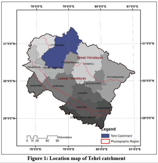 |
Figure 1: Location map of Tehri catchment Click here to view Figure |
 |
Figure 2: Location map Major rivers and tributaries of Tehri Catchment Click here to view Figure |
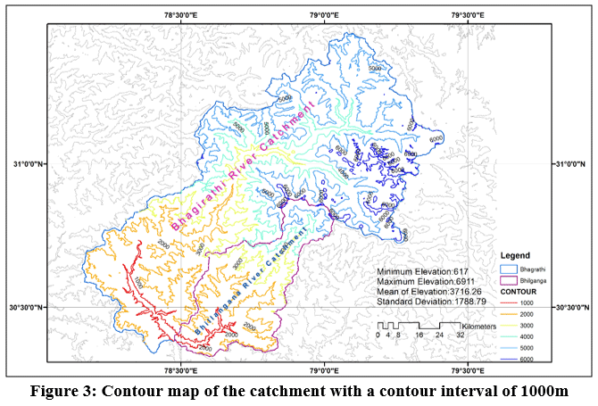 |
Figure 3: Contour map of the catchment with a contour interval of 1000m Click here to view Figure |
Delineation of catchment and sub-catchments
To develop the inflow forecasting model, the Tehri catchment has been divided into four parts.
- Bhagirathi up to Maneri Bhali II (Catchment area 4693 Km2)
- Bhilangana up to Ghansali, (Catchment area 792 Km2)
- Balganga up to Sarasgaon, (Catchment area 488 Km2)
- Intermediate catchment. (Catchment area 1320 Km2)
Intermediate catchment contains 16 ungauged tributaries which are falling directly into the reservoir and the unaccounted area, i.e. reservoir area and the catchment of some very small tributaries falling directly into the reservoir. Intermediate catchment does not receive any snowfall and is rainfed only. To delineate the catchment (Figure 4) and sub-catchments SRTM DEM data of 30m resolution have been used. The catchment area and the area of each of sub-catchments along with the areas of smaller watersheds at different outlets are shown in Table 1. Sub-catchment maps of Bhilangana at Ghansali, Balganga at Sarasgaon, Bhagirathi at Maneri Bhali II and intermediate catchment are presented in Figs. 5, 6, 7 and 8 respectively. Catchment area between different elevation bands of Bhilangana, Balganga, Bhagirathi and intermediate catchments are presented in Table 2 to 5. The snow and non-snow areas during accumulation (24.3.2001 and 10.05.2001) and depletion period (10.10.2001 and 7.9.20014) of Bhagirathi catchment are shown in Figure 9 to 12.14
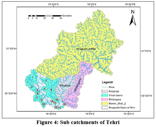 |
Figure 4: Sub catchments of Tehri Click here to view Figure |
Table 1: Catchment area details
|
SN. |
Description of Catchment / Sub catchments |
Area (Km2) |
|
1 |
At Tehri dam |
7293.0 |
|
2 |
Bhagirathi at Dam axis |
5807.0 |
|
3 |
Bhilangana at Dam axis |
1486.0 |
|
4 |
Bhagirathi Catchment at Maneri Bhali II |
4693.0 |
|
5 |
Bhilangana Catchment at Ghansali |
792.0 |
|
6 |
Balganga catchment at Sarasgaon (Ghansali) |
488.0 |
|
7 |
Intermediate Catchment between MB II and Ghansali |
1320 |
|
8 |
Area of 10 small streams falling directly into the reservoir, Bhagirathi side |
943.0 |
|
9 |
Area of 6 small streams falling directly into the reservoir, Bhilangana side |
189.0 |
|
10 |
Reservoir area at full reservoir level i.e. at 830m |
42.0 |
|
11 |
Unaccounted area of other very small tributaries falling directly into the reservoir. |
146.0 |
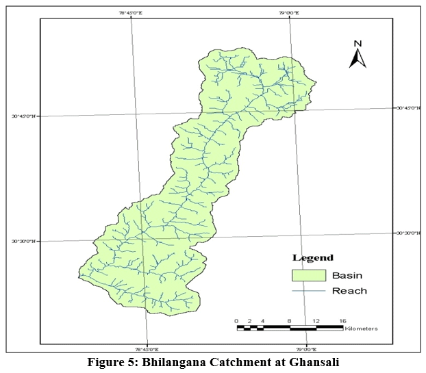 |
Figure 5: Bhilangana Catchment at Ghansali Click here to view figure |
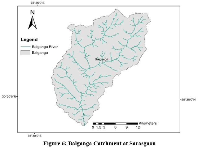 |
Figure 6: Balganga Catchment at Sarasgaon Click here to view Figure |
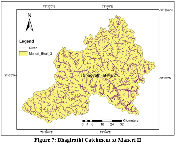 |
Figure 7: Bhagirathi Catchment at Maneri II Click here to view Figure |
 |
Figure 8: Intermediate catchment between Maneri II and Ghansali Click here to view Figure |
Table 2: Elevation band wise area of Bhilangana catchment up to Ghansali
|
Elevation Bands |
Elevation Range (M) |
Catchment Area (KM2) |
Percentage (%) |
|
1 |
Upto 2000 |
190 |
24 |
|
2 |
2000-2800 |
182 |
23 |
|
3 |
2800-4000 |
158 |
20 |
|
4 |
4000-4800 |
122 |
16 |
|
5 |
4800-5600 |
90 |
11 |
|
6 |
5600-6717 |
49 |
6 |
Table 3: Elevation band wise area of Balganga catchment up to Sarasgaon
|
Elevation Bands |
Elevation Range (M) |
Catchment Area (KM2) |
Percentage (%) |
|
1 |
Upto 1400 |
50 |
10 |
|
2 |
1400-2000 |
110 |
22 |
|
3 |
2000-2800 |
130 |
26 |
|
4 |
2800-4000 |
100 |
20 |
|
5 |
4000-4826 |
99 |
20 |
Table 4: Elevation band wise area of Bhagirathi catchment up to MBII
|
Elevation Bands |
Elevation Range (M) |
Catchment Area (km2) |
Percentage (%) |
|
1 |
Upto 2000 |
488 |
10.4 |
|
2 |
2000-2800 |
452 |
9.6 |
|
3 |
2800-4000 |
554 |
11.8 |
|
4 |
4000-4800 |
892 |
19.0 |
|
5 |
4800-6000 |
1607 |
34.2 |
|
6 |
6000-7085 |
700 |
14.9 |
Table 5: Elevation band wise area of the intermediate catchment
|
Elevation Bands |
Elevation Range (M) |
Catchment Area (km2) |
Percentage (%) |
|
1 |
Upto 1200 |
312 |
23.7 |
|
2 |
1200-1600 |
340 |
25.8 |
|
3 |
1600-2000 |
196 |
14.9 |
|
4 |
2000-2400 |
243 |
18.4 |
|
5 |
2400-2826 |
229 |
17.4 |
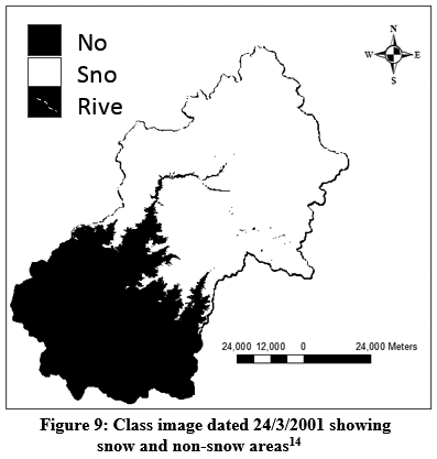 |
Figure 9: Class image dated 24/3/2001 showing snow and non-snow areas14 Click here to view Figure |
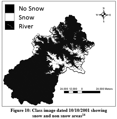 |
Figure 10: Class image dated 10/10/2001 showing snow and non snow areas14 Click here to view figure |
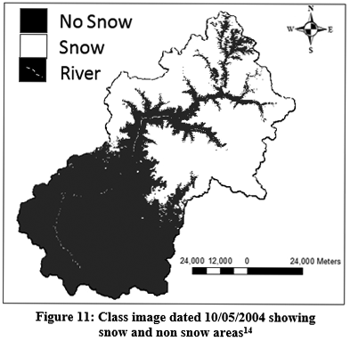 |
Figure 11: Class image dated 10/05/2004 showing snow and non snow areas14 Click here to view Figure |
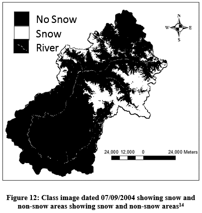 |
Figure 12: Class image dated 07/09/2004 showing snow and non-snow areas showing snow and non-snow areas14 Click here to view Figure |
Approximately 28% catchment has permanent snow. Snow gets accumulated up to 55% of the catchment at the start of depletion period. As mentioned above, Bhagirathi river catchment has been divided into four parts, i.e. Bhagirathi up to MBII, Bhilangana up to Ghansali, Balganga up to Sarasgaon and Intermediate catchment. The catchment area of river Bhagirathi, Bhilangana and Balganga are divided into 6, 6 and 5 elevation bands respectively. The maximum elevation of these catchments are 7085 m, 6717 m and 4826 m respectively. Similarly the minimum elevation of these catchments at the outlet is 983m, 855m and 870m respectively. 2752 km2 area of Bhagirathi catchment is above 2800m elevation. Primarily this area makes river Bhagirathi as perennial. The intermediate catchment is 1320 km2 and is only rainfed. The major contribution in run-off from this area comes during monsoon season. The ungauged tributaries from this area are contributing directly into the reservoir. The physiographic analysis of these tributaries shows that bifurcation ratio of these 16 tributaries varies between 2.02 and 2.09. The area ratios vary between 2.65 and 5.2 and length ratios vary between 1.89 and 3.76.
Extraction of Geomorphological Characteristics
Geomorphological characteristics of the catchments of the ungauged tributaries have been extracted using Arc GIS 10.1. The method of quantitative analysis of channel networks presented by Horton15 and later revised by Strahler16 has been used for stream ordering as follows:
- Channel that originates at a source is first order streams.
- Once the streams of same order (ω) joins, a stream of next higher order (ω+1) is formed.
- A stream below the confluence of two different order streams has the order same as the higher order stream.
- After carrying out the stream ordering in the basin, the highest stream order Ω is defined as order of the basin.
The following set of laws suggested by Horton, for indicating the geomorphological characteristics of the watershed have been used.
Horton’s Law of Stream Number: According to it stream order and total number of streams falling under a specific stream order show inverse geometric relationship expressed as:.
Nω = RB Ω-ω (1)
where Ω is the order of highest order stream in the network, ω is the order of interest and RB is a constant for a given river network called as bifurcation ratio.
Also;
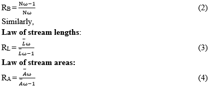
where RL and RA are the length and area ratio and L- ω and A- ω are the average stream length and stream area of the order ω.
The overall bifurcation ratio of the catchment, length ratio and area ratio can be calculated either by the arithmetic average method or graphical method. In the graphical method, the plot of the logarithm of Nω, Lw or Ä€ω versus order ω approximately fit a straight line. The magnitudes of the slope of the straight lines are logthe arithm of RB, RL and RA. Stream order, length of the stream, maximum and minimum elevation of stream segments and the contributing area of each sub-catchment are extracted separately by analyzing the DEM in Arc-GIS.
The bifurcation ratio (RB), the Area ratio (RA) and Length ratio (RL) are calculated for all the sixteen streams using the graphical method. The Horton’s ratios for all the 16 stream lie within limits given for the natural streams.
The physiographic features of 16 small streams falling directly into the reservoir are extracted using GIS. These geomorphologic details are tabulated in Tables 6 and 7 respectively.
Table 6: Extracted Physiographic features of small streams falling directly into the reservoir using GIS
|
S. No |
Stream Order 1 |
Stream Order 2 |
Stream Order 3 |
Stream Order 4 |
||||||||
|
Nos |
Avg (A) |
Avg (L) |
Nos |
Avg. (A) |
Avg. (L) |
Nos |
Avg. (A) |
Avg (L) |
Nos |
Avg (A) |
Avg (L) |
|
|
1 |
68 |
1.29 |
.92 |
21 |
5.82 |
1.12 |
5 |
32.50 |
4.17 |
1 |
179.05 |
19.88 |
|
2 |
28 |
2.14 |
1.24 |
8 |
8.62 |
4.01 |
2 |
35.86 |
22.03 |
1 |
108.02 |
25.20 |
|
3 |
24 |
2.16 |
1.15 |
5 |
13.91 |
2.39 |
2 |
39.20 |
3.14 |
1 |
90.29 |
17.67 |
|
4 |
12 |
2.65 |
1.40 |
2 |
18.45 |
7.20 |
1 |
46.14 |
11.57 |
|||
|
5 |
6 |
0.69 |
0.67 |
2 |
2.37 |
1.72 |
1 |
11.44 |
7.88 |
|||
|
6 |
9 |
0.88 |
0.66 |
3 |
2.48 |
1.97 |
1 |
16.27 |
9.03 |
|||
|
7 |
19 |
2.12 |
1.18 |
7 |
6.86 |
3.67 |
2 |
29.32 |
7.51 |
1 |
69.67 |
18.03 |
|
8 |
61 |
2.82 |
1.59 |
14 |
13.68 |
3.94 |
4 |
54.87 |
9.36 |
1 |
259.03 |
35.86 |
|
9 |
10 |
1.10 |
0.81 |
2 |
5.52 |
3.149 |
1 |
21.33 |
10.26 |
|||
|
10 |
14 |
1.77 |
1.10 |
3 |
8.28 |
3.82 |
1 |
41.88 |
11.93 |
|||
|
11 |
8 |
0.79 |
5.76 |
2 |
4.39 |
4.88 |
1 |
13.19 |
7.35 |
|||
|
12 |
5 |
0.92 |
0.56 |
2 |
3.31 |
1.04 |
1 |
7.77 |
3.65 |
|||
|
13 |
6 |
2.01 |
1.14 |
2 |
7.85 |
4.00 |
1 |
16.98 |
7.15 |
|||
|
14 |
4 |
1.80 |
0.76 |
2 |
4.86 |
2.35 |
1 |
12.64 |
5.90 |
|||
|
15 |
11 |
2.75 |
1.71 |
3 |
12.40 |
3.87 |
1 |
43.94 |
10.53 |
|||
|
16 |
6 |
1.03 |
0.82 |
2 |
3.59 |
1.60 |
1 |
14.23 |
7.42 |
|||
Table 7: Geomorphologic features of 16 streams falling directly into the reservoir
|
S. No. |
RB |
RA |
RL |
AΩ |
LΩ |
Avg. S (m/Km) |
|
1 |
4.09 |
5.2 |
2.48 |
179.05 |
19.89 |
39.24 |
|
2 |
3.17 |
3.73 |
2.76 |
108.029 |
25.206 |
44.27 |
|
3 |
2.84 |
3.39 |
1.89 |
90.29 |
17.67 |
52.38 |
|
4 |
3.50 |
4.72 |
3.37 |
46.146 |
11.576 |
108.83 |
|
5 |
2.50 |
4.11 |
3.57 |
11.447 |
7.887 |
135.68 |
|
6 |
3.00 |
4.68 |
3.76 |
16.274 |
9.035 |
92.554 |
|
7 |
2.74 |
3.29 |
2.52 |
69.679 |
18.039 |
49.43 |
|
8 |
3.95 |
4.53 |
2.89 |
259.036 |
35.863 |
35.53 |
|
9 |
3.50 |
4.43 |
3.57 |
21.336 |
10.262 |
76.62 |
|
10 |
3.83 |
4.86 |
3.30 |
41.811 |
11.937 |
51.79 |
|
11 |
3.00 |
4.28 |
3.20 |
13.196 |
7.352 |
141.891 |
|
12 |
2.25 |
3.70 |
2.35 |
7.779 |
3.651 |
145.53 |
|
13 |
2.50 |
3.03 |
2.65 |
16.987 |
7.155 |
125.67 |
|
14 |
2.00 |
2.65 |
2.79 |
12.648 |
5.904 |
101.46 |
|
15 |
3.33 |
4.02 |
2.49 |
43.948 |
10.53 |
80.48 |
|
16 |
3.00 |
3.49 |
1.95 |
14.243 |
7.423 |
109.03 |
Development of GIUH based Nash Model for 16 Ungauged Tributaries
GIUH based Nash Model
In an ungauged basin unit hydrograph’s complete shape is determined by connecting peak flow (qp) and time to peak (tp) of GIUH with Nash IUH parameters:
tp = 0.44 RL-0.38 (RB/RA)0.55 (Lω/V) ....... (6)
Multiplying qp with tp we get the expression which is independent of velocity parameter as below;
qp * tp = 0.576*(RB/RA)0.55*RL0.05 ....... (7)
Nash IUH model is defined as:
u(t) = (1/(k*Гn)) (t/k) n-1 e-t/k ........ (8)
where, u(t) denotes IUH ordinates in hour-1 and t is sampling time interval in hour, k is scale parameter and n is shape parameter of the Nash IUH and Гn is the gama value of shape factor (n).
Taking first derivative of Nash IUH equation with respect to t and equating it to zero:

At peak discharge t becomes tp, then
Thus,
qp = (1/(k * Гn)) (n-1) n-1 e-(n-1) (11)
Multiplying qp with tp we get
qp * tp = (n-1)/ (Гn)* (n-1) n-1 e-(n-1) (12)
Equating equations (4.3) and (4.8) we get;

Value of parameter n can be found by equation (13) through Newton- Rapson method. Value of parameter k for the known values of velocity V and parameter n is computed as:
From the geomorphologic characteristics and Horton’s ratio of each sub-catchment, the IUH parameters qp and tp for GIUH-Nash model are calculated. The GIUH-Nash method gives the complete shape of IUH. The ordinates of IUH are multiplied by the watershed area to get the UH ordinates.
Contribution of Ungauged Tributaries Falling Directly into the Reservoir
A number of models are mentioned in the literature which are modelling rainfall-runoff process in a basin using SCS-CN method in a gauged basin.17 Using the climate change projections,18 one can use such models for predicting the behaviours of river flows. Furthermore, various modelling techniques e.g. linear transfer function, artificial neural networks, Fuzzy Logic, ANFIS have also been used in gauged catchments.19,20,21,22,23 However, for ungauged catchment rainfall-runoff process can be modelled through GIUH models. Therefore, runoff from the 16 ungauged tributaries has been computed using the GIUH-Nash model. The GIUH based Nash model is used to compute 1 h UH of each of the 16 tributaries. GIUH-Nash Model parameters n and k and qp and tp for all the ungauged tributaries are presented in Table 8. The IUHs of the16 tributaries are presented in Fig 13. The UH ordinates are given in Table 9. To develop the DSRO, using GIUH-Nash model, hourly rainfall distribution of effective rainfall hyetograph is required. Hourly data of 4 stations namely Dharasu, Tehri, Lambgaon and Ghansali stations have been used in the convolution of rainfall to develop the DSRO of all the 16 tributaries. Uniform infiltration loss rate of 3mm per hour has been taken to prepare the ERH. The ERH of respective catchments of all the 16 tributaries is convoluted with the respective 1h unit hydrograph for computing surface runoff hydrographs. After convolution of effective rainfall, the direct surface runoff of each of the tributaries has been computed. Typical time series plots of the runoff of some of the tributaries are presented in Fig. 14.
Table 8: GIUH-Nash Model parameters n and k and qp and tp of the ungauged tributaries
|
S. No. |
GIUH-Nash Model |
|||
|
n |
k |
qp (m3/s/km2) |
tp (hr) |
|
|
1 |
3.12 |
1.32 |
0.187 |
3.5 |
|
2 |
3.10 |
1.27 |
0.208 |
2.67 |
|
3 |
2.90 |
1.12 |
0.23 |
2.87 |
|
4 |
2.85 |
0.50 |
0.559 |
0.93 |
|
5 |
2.55 |
0.42 |
0.720 |
0.65 |
|
6 |
2.60 |
0.50 |
0.608 |
0.79 |
|
7 |
3.05 |
1.04 |
0.257 |
2.12 |
|
8 |
3.15 |
1.68 |
0.156 |
3.61 |
|
9 |
3.00 |
0.53 |
0.514 |
1.05 |
|
10 |
2.95 |
0.65 |
0.422 |
1.27 |
|
11 |
2.75 |
0.38 |
0.752 |
0.67 |
|
12 |
2.85 |
0.20 |
1.133 |
0.37 |
|
13 |
3.00 |
0.38 |
0.707 |
0.77 |
|
14 |
2.40 |
0.35 |
0.895 |
0.50 |
|
15 |
3.00 |
0.57 |
0.477 |
1.14 |
|
16 |
3.05 |
0.44 |
0.611 |
0.90 |
 |
Figure 13: IUH of tributary 1 to 16 (T1 to T16) developed by GIUH-NASH Model Click here to view Figure |
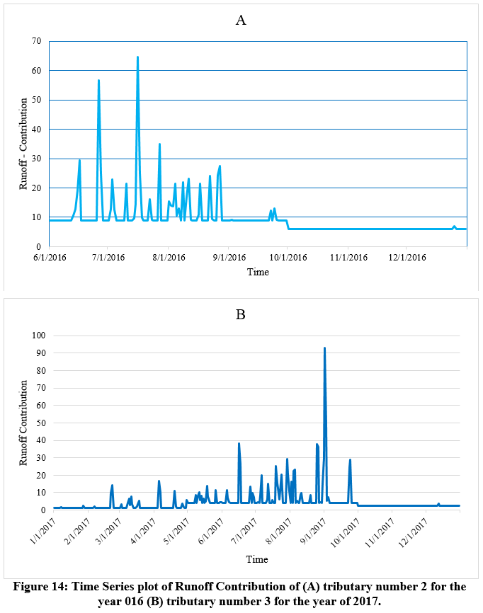 |
Figure 14: Time Series plot of Runoff Contribution of (A) tributary number 2 for the year 016 (B) tributary number 3 for the year of 2017. Click here to view Figure |
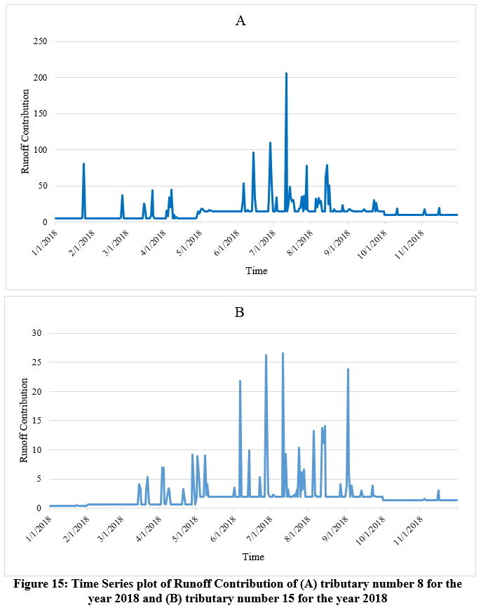 |
Figure 15: Time Series plot of Runoff Contribution of (A) tributary number 8 for the year 2018 and (B) tributary number 15 for the year 2018 Click here to view Figure |
Table 9: 1H-UH for 16 Tributaries (GIUH-Nash Model)
|
Time |
Small Streams |
|||||||||||||||
|
1 |
2 |
3 |
4 |
5 |
6 |
7 |
8 |
9 |
10 |
11 |
12 |
13 |
14 |
15 |
16 |
|
|
0 |
0.0 |
0.0 |
0.00 |
0.0 |
0.0 |
0.0 |
0.0 |
0.0 |
0.0 |
0.0 |
0.0 |
0.0 |
0.0 |
0.0 |
0.0 |
0.0 |
|
1 |
8.0 |
19.0 |
22.00 |
69.0 |
24.5 |
29.0 |
21.5 |
19.0 |
26.3 |
38.0 |
27.9 |
21.2 |
31.4 |
31.4 |
47.3 |
22.3 |
|
2 |
48.0 |
55.0 |
54.00 |
45.7 |
6.7 |
13.5 |
50.8 |
69.9 |
23.2 |
46.5 |
8.0 |
0.4 |
13.5 |
3.6 |
48.9 |
13.7 |
|
3 |
98.0 |
66.0 |
61.00 |
11.2 |
0.6 |
2.3 |
49.0 |
107.0 |
7.6 |
21.9 |
0.8 |
0.0 |
2.0 |
0.1 |
19.2 |
3.0 |
|
4 |
113.0 |
57.0 |
47.00 |
1.9 |
0.0 |
0.3 |
33.8 |
117.0 |
1.8 |
7.3 |
0.1 |
|
0.2 |
0.0 |
5.3 |
0.5 |
|
5 |
93.0 |
41.0 |
30.00 |
0.3 |
|
0.0 |
19.5 |
107.2 |
0.3 |
2.0 |
0.0 |
|
0.0 |
|
1.2 |
0.1 |
|
6 |
63.0 |
26.5 |
18.00 |
0.0 |
|
|
10.1 |
88.0 |
0.1 |
0.5 |
|
|
|
|
0.3 |
0.0 |
|
7 |
37.0 |
16.0 |
9.50 |
|
|
|
4.9 |
67.0 |
0.0 |
0.1 |
|
|
|
|
0.0 |
|
|
8 |
19.0 |
9.0 |
5.00 |
|
|
|
2.2 |
48.5 |
|
0.0 |
|
|
|
|
|
|
|
9 |
9.5 |
5.0 |
2.50 |
|
|
|
1.0 |
33.6 |
|
|
|
|
|
|
|
|
|
10 |
4.5 |
2.7 |
1.00 |
|
|
|
0.4 |
22.6 |
|
|
|
|
|
|
|
|
|
11 |
2.0 |
1.4 |
0.50 |
|
|
|
0.2 |
14.8 |
|
|
|
|
|
|
|
|
|
12 |
0.8 |
0.7 |
0.25 |
|
|
|
0.0 |
9.5 |
|
|
|
|
|
|
|
|
|
13 |
0.4 |
0.4 |
0.13 |
|
|
|
|
6.0 |
|
|
|
|
|
|
|
|
|
14 |
0.2 |
0.2 |
0.00 |
|
|
|
|
3.7 |
|
|
|
|
|
|
|
|
|
15 |
0.1 |
0.1 |
|
|
|
|
|
2.3 |
|
|
|
|
|
|
|
|
|
16 |
0.0 |
0.0 |
|
|
|
|
|
1.4 |
|
|
|
|
|
|
|
|
|
17 |
|
|
|
|
|
|
|
0.9 |
|
|
|
|
|
|
|
|
|
18 |
|
|
|
|
|
|
|
0.5 |
|
|
|
|
|
|
|
|
|
19 |
|
|
|
|
|
|
|
0.3 |
|
|
|
|
|
|
|
|
|
20 |
|
|
|
|
|
|
|
0.2 |
|
|
|
|
|
|
|
|
|
21 |
|
|
|
|
|
|
|
0.0 |
|
|
|
|
|
|
|
|
Conclusions
The catchment area of river Bhagirathi at Tehri is 7293 km2 and approximately 28% of the catchment is permanently covered with snow. In this study Bhagirathi river catchment has been divided into four parts, i.e. Bhagirathi up to MBII, Bhilangana up to Ghansali, Balganga up to Sarasgaon and Intermediate catchment. Spatial data analysis indicates that 2752 km2 area of catchment up to MBII is above 2800m elevation which makes river Bhagirathi perennial. The intermediate catchment is having a drainage area of 1320 km2 and is fully rainfed. The major contribution of this area comes during the monsoon season. Sixteen ungauged tributaries from this area are contributing directly into the reservoir. The physiographic analysis of these tributaries shows that bifurcation ratios of these 16 tributaries vary from 2.02 to 2.09. The area ratios vary from 2.65 to 5.2 and length ratios vary from 1.89 to 3.76. These ratios indicate that the catchments of these tributaries are normal shaped. Further for these ungauged tributaries GIUH models have been developed. The GIUH is capable to model the rainfall-runoff process for the ungauged tributaries falling directly into the reservoir, thus it can provide a useful input for the development of inflow forecasting model for the Tehri dam.
References
- Valdes, J. B., Fiallo, Y. and Rodriguez-Iturbe, I. A Rainfall-Runoff Analysis of the Geomorphologic IUH. Water Resources Research. 1979; 15(6):1421-1434.
CrossRef - Rodriguez-Iturbe, I., Devoto, G., and Valdes, J. B. Discharge Response Analysis and Hydrologic Similarity: The Interrelation between the Geomorphologic IUH and the Storm Characteristics. Water Resources Research. 1979;15(6): 1435-1444.
CrossRef - Rodriguez-Iturbe, I., Gonzalez-Sanabria, M. and Cammano, G. On The Climatic Dependance of the IUH: A Rainfall-Runoff Analysis of Nash Model and the Geomorphoclimatic Theory. Water Resources Research. 1982;18(4):887-903.
CrossRef - Rosso, R. Nash Model Relation to Horton Order Ratios. Water Resources Research. 1984; 20(7): 914-920.
CrossRef - Panigrahi, R.K. Derivation of Nash Model Parameters From Geomorphological Instantaneous Unit Hydrograph. Department of Hydrology, University of Roorkee. M.E. Dissertation.1991.
- Kumar, R., Chatterjee, C., Lohani, A. K., Kumar, S. and Singh, R. D. Sensitivity Analysis of the GIUH based Clark Model for a Catchment. Water Resources Management 2002; 16(4): 263-278.
CrossRef - Kumar, R., Chatterjee, C., Singh, R. D., Lohani, A. K. and Nema, R. K. Flood estimation for ungauged catchments using GIS and GIUH based Nash model. Asian-Pacific Remote Sensing and GIS Journal, 2003;15:11-20.
- Kumar, R., Chatterjee, C., Singh, R. D., Lohani, A. K. and Kumar, S. GIUH based Clark and Nash models for runoff estimation for an ungauged basin and their uncertainty analysis. International Journal of River Basin Management. 2004; 2(4):1-11.
CrossRef - Kumar, R., Chatterjee, C., Singh, R. D., Lohani, A. K. and Kumar, S. Runoff estimation for an ungauged catchment using geomorphological instantaneous unit hydrograph (GIUH) models, Hydrological Processes. 2007; 21(14):1829-1840.
CrossRef - Sarkar, S. and Rai, R.K. Flood Inundation Modelling Using Nakagami-m Distribution Based GIUH for a Partially Gauged Catchment. Water Resources Management. 2011; 25(14): 3805.
CrossRef - Singh, P.K., Mishra, S.K. and Jain, M.K. A review of synthetic unit hydrograph: from the empirical UH to advanced geomorphological methods. Hydrological Sciences Journal. 2013; 59(2): 239-261.
CrossRef - Khatri, S. Simulation of June 2013 flood at Tehri Dam. M.Tech. Thesis, Department of Hydrology, Indian Institute of Technology Roorkee. Unpublished work. 2014.
- Swain, J. B., Jha, R., and Patra, K. C. Stream Flow Prediction in a Typical Ungauged Catchment Using GIUH Approach. Aquatic Procedia, 4(ICWRCOE). 2015; 993–1000.
CrossRef - Agrawal, N. Modeling of Snowmelt Component of Runoff of Bhagirathi Catchment at Tehri. M.Tech.Thesis, Department of Hydrology, Indian Institute of Technology Roorkee. Unpublished Work. 2009.
- Horton, B. Y. R. E. Erosional Development of Streams and their Drainage Basins; Hydrophysical Approach to Quantitative Morphology. Bulletin of the Geological Society of America, 1945. 56(March):275–370.
CrossRef - Strahler, A. N. Quantitative analysis of watershed geomorphology. Transactions of the American Geophysical Union. 1957; 38 (6): 913–920.
CrossRef - Chavda D. B, Makwana J. J, Parmar H. V, Kunapara A. N, Prajapati G. V. Estimation of Runoff for Ozat Catchment using RS and GIS Based SCS-CN Method. Curr World Environ 2016;11(1) DOI:http://dx.doi.org/10.12944/CWE.11.1.26
CrossRef - Parvaze S, Parvaze S, Haroon S, Khurshid N, Khan J. N, Ahmad L. Projected Change in Climate Under A2 Scenario in Dal Lake Catchment Area of Srinagar City in Jammu and Kashmir. Curr World Environ 2016;11(2) DOI:http://dx.doi.org/10.12944/CWE.11.2.11
CrossRef - Lohani A.K., Goel N.K., and Bhatia K.K.S. Real time flood forecasting using fuzzy logic. Hydrological Perspectives for Sustainable Development, Volume I, Eds. M. Perumal, Allied Publishers Pvt. Ltd., New Delhi. 2005;168-176.
- Lohani, A.K., Kumar Rakesh, Singh R.D. Hydrological Time Series Modeling: A Comparison Between Adaptive Neuro Fuzzy, Neural Network and Auto Regressive Techniques. Journal of Hydrology, Elsevier. 2012; 442-443 (6), 23-35.
CrossRef - Lohani, A.K., Goel, N.K., Bhatia, K.K.S. Rainfall Runoff Modelling Using Fuzzy Rule Based Approach. International Conference on Water, Environment, Energy and Society (WEES). Hydrologic and Hydraulic Modelling. 2009; I:257–263.
- Lohani, A.K., Goel, N.K., Bhatia, K.K.S. Comparative study of neural network, fuzzy logic and linear transfer function techniques in daily rainfallrunoff modeling under different input domains. Hydrological Processes.2011; 25:175–193.
CrossRef - Lohani A.K, Goel N.K. and Bhatia K.K.S. Improving real time flood forecasting using fuzzy inference system. Journal of Hydrology. 2014; 509(13):25–41.
CrossRef


