Rainfall Runoff Modeling Using MIKE 11 NAM Model
Pushpendra Kumar1 , A.K. Lohani2 * and A.K. Nema1
http://dx.doi.org/10.12944/CWE.14.1.05
Copy the following to cite this article:
Kumar P, Lohani A. K, Nema A.K. Rainfall Runoff Modeling Using MIKE 11 NAM Model. Curr World Environ 2019;14(1). DOI:http://dx.doi.org/10.12944/CWE.14.1.05
Copy the following to cite this URL:
Kumar P, Lohani A. K, Nema A.K. Rainfall Runoff Modeling Using MIKE 11 NAM Model. Curr World Environ 2019;14(1). Available from: https://bit.ly/2GIIBbO
Download article (pdf)
Citation Manager
Publish History


Introduction
While modelling the rainfall-runoff process of a basin it is to be noted that this process is highly nonlinear and time-varying. Such properties of this hydrological process indicate that it is always a challenging task to describe it by simple models. In reality, the response of a catchment show high temporal variability throughout the year and this variability depends on rainfall pattern (both temporal and spatial), evaporation, catchment characteristics and many other hydrological parameters. A number of hydrological models were demonstrated by various investigators for addressing such modelling issues.1 Artificial Neural Networks are increasingly used in modelling various hydrological processes and flood forecasting.2 A number of attempts have also been made to apply fuzzy models in flood forecasting,3,4,5,6 stage discharge relationship7,8,9 which provides important input for rainfall-runoff modelling. Furthermore, inherent nonlinearity of the hydrological processes can be modelled by the Fuzzy rule-based systems as demonstrated by the researchers through monthly reservoir inflow forecasting10 and flood forecasting.11,12,13 Conceptual and physical based models are being successfully applied for runoff simulation. Most of the models which are commonly used for the simulation of catchment runoff are lumped, conceptual models. Simulation models have a vital role in integrated water resource development management and related decision making. Various available rainfall-runoff models consider different model structures. Some of the most common models are Green and Ampt14; Rational15; SCS-CN,16 and for ungauged basins geomorphological unit hydrograph (GIUH).18,19,20,21 A number of conceptual models represent the physical processes lumped over the entire catchment. Such a model is the HBV,22 Sacramento,23 the Tank,24 HEC25,26,27and the NAMMIKE11.28,29 Selection of a hydrological model is generally based on available hydro-metrological data, hydrological problem and accuracy criteria. In general, the parameters of hydrological models can’t be acquired directly from the basin features, therefore, the model calibration is required to finalise the parameter values.
In this paper rainfall runoff, processforArpabasinup to Kota has been modelled using MIKE11 NAM software. In the Arpa basin available water resources are overexploited and therefore immediate steps are required to develop water resources in the basin so as to fulfil the growing demands of water. Using the rainfall and evaporation daily series of the study basin the runoff was simulated. The model parameters are considered in such a way so that the model simulates the runoff from the Arpabasinwith the desired accuracy. The model calibration may be carried out manually or automatic algorithms. In manual calibration, the model parameter is generally adjusted by trial-and-error and visual judgment.
Study Area
The origin of the river Mahanadi is near village Pharsiya in Raipur, Chhattisgarh. Seonath river is a tributary of Mahanadi while the Seonath river’s tributary is Arpa river. The Arpa Basin is located at latitude 2208'N and Longitude 82005'E. The Arpa river having a catchment area as 1681.8 km2 and it originates from Bilaspur, Chhattisgarh, India. River Arpa is very wide from Belghan to Bilapur. Bed of the Arpa river is sandy with exposed rocks at certain places. The major portion of the Arpa river basin is having red yellow and laterite soils. In the basin, about 60 to 62% area is having red yellow soil and 35 to 45% area is having laterite soils. Rest 5 to 10% area of the basin have other soils like red alluvial, red sandy, black and peat soils.30 Rainfall and temperature in the study area indicate significant variations from month to month indicating the lowest temperature as 11.62oC and highest as 46.35oC. The average rainfall of the Arpa basin is 135 cm and forest area of the basin falls under tropical forest.30 The Arpa basin (study area) which is located on Seonanath river is shown in Fig. 1.
Description of NAM Model
The NAM model28 has been used in the present study for modelling of the rainfall-runoff process. NAM model is based on the hydrological cycle and different parameters used in the model are taken as the average value of the whole watershed. NAM model structure is presented in Figure 2. NAM model has four storage layers e.g. (i) snow (ii) surface (iii) lower zone and (iv) underground ad three flows e.g. (i) overland flow (QOF), interflow (QIF) and underground flow (QBF). The NAM model can either be applied independently in a catchment or in a network form by dividing large basin into small sub-basins. Thus the model gives an opportunity to consider a single sub-basin or a large river basin divided in the number of sub-basins with the complex river. This model also has the capability to model most common man-made hydrological interventions e.g. irrigation and groundwater pumping. In NAM model inputs are precipitation, potential evaporation and temperature and the output is a runoff. The model parameters can be decided on the basis of catchment characteristics, however, the final values of the model parameter are decided after model calibration. In this paper, parameters have been estimated using a combination of auto-calibration and manual calibration.
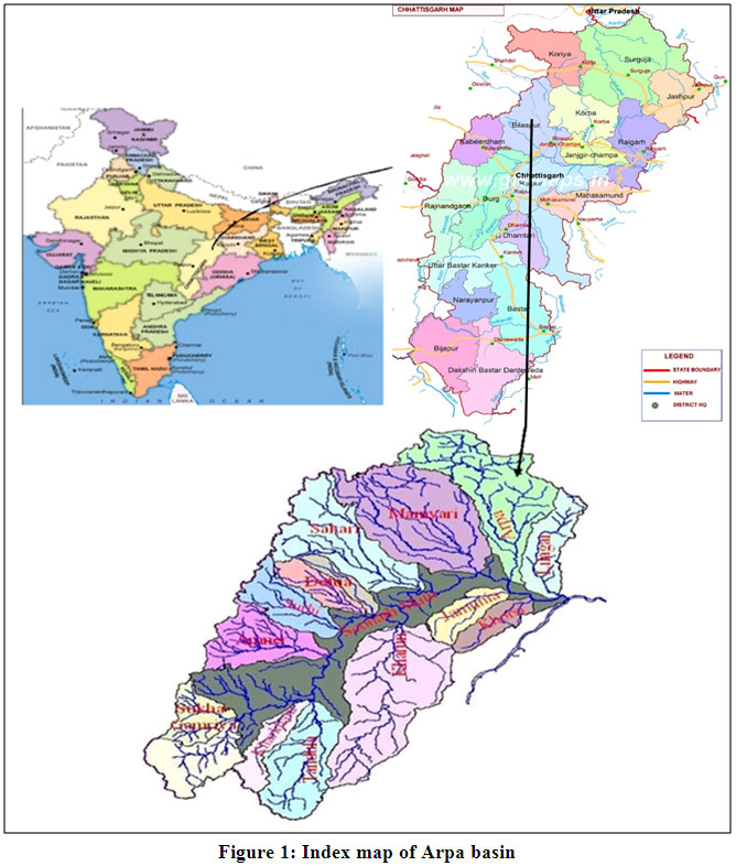 |
Figure 1: Index map of Arpa basin Click here to view Figure |
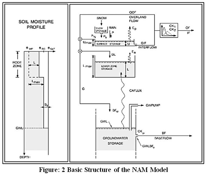 |
Figure: 2 Basic Structure of the NAM Model Click here to view Figure |
The NAM model has an optimization module for the multi-objective parameter calibration. It uses shuffled complex evolution algorithm. Multi-objective optimization methodconsiders following 4 objective functions:

Overall root means square error (RMSE) which gives overall agreement of hydrograph shape:

Average RMSE of Peak Flow events for good agreement respect to peak flow timing, rate and volume

Average RMSE of low flow events

Where,
Qobs,j = Observed discharge at time i
Qsim,j = Simulated discharge at time i
N= Total number of time steps
Mp = Number of peak flow events
Ml = Number of low flow events
Nj = Number of time steps in peak/low flow event no. j
Θ = set of model parameters
Wi = Weighting function
Depending upon the application of the rainfall-runoff model, one can decide specific combinations of the above mentioned objective functions.
Input Data
As mentioned in the previous section, in NAM model meteorological data, streamflow data are the inputs. Therefore, ten years daily rainfall of Kota, Khtghatand Maniyarii.e. from 2000 to 2009 ware used for the modelling. It has observed that there is no missing data in the available time series. The usefulness of HYMOS software in processing of metrological and hydrological has been demonstrated by various researchers.32,33,34,35,36 The computation of the average rainfall has been performed using HYMOS software using the layers of the base map (basin boundary) and rain gauge location map. The Thiessen weights for each rain gauge station have been computed as a ratio of the influencing area of each station divided by the total basin area. Discharge data of Kota site on Arpabasinfrom 2000 to 2009 was used for the rainfall-runoff modelling. Before using these data for the development of the model, the rainfall and runoff records were checked for their consistency and corrected using the HYMOS software. Daily ET(evapotranspiration) data of the basin were collected from the water resource department, Chhattisgarh and used for the analysis.
MIKE 11 NAM Model Setup
In order to simulate runoff from Arpa basin, NAM model inputs were prepared. The input data of daily rainfall, runoff and potential evapotranspiration at Kota gauge discharge site of Arpabasin for the period of ten years from 2000 to 2009 were used in the model. During the calibration of NAM model, fine-tuning of the model parameters was carried out so as to obtain an acceptable matching of simulated and observed streamflow data. Rainfall-runoff data from 2000 to 2003 have been applied for the model calibration. During calibration, adjustment of model parameters has been carried out using automatic calibration option of the NAM model. The optimum parameters values obtained using the auto calibration option and finally verified using trial & error are considered for determining the runoff from the Arpa basin. After the calibration, the model was then tested for selected period i.e from 2004 to 2009. Further, the model statistics of the calibration and validation results were used to verify the model usefulness in runoff prediction.
Accuracy Criteria
The capability of rainfall runoff model was assessed using coefficient of determination(R2), Nash–Sutcliffe Efficiency Index (EI)and Root Mean Square Error (RMSE). EI was developed to evaluate goodness between simulated and observed runoff. When EI value is 1it indicates the perfect model. The coefficient of determination(R2) of NAM model was calculated by using the following equation:

Nash and Suticliffe efficiency index37is given as:

RMSE method38 was also applied for evaluating MIKE11NAM. This method measures error between the computed and observed values. RMSE values equal to zero indicate the computed and observed values are matching perfectly. RMSE is given as:

Where,
Qobs = observed flow at time i number of data points
Qobs= mean value of observed flow = 
Qsim= simulated flow at time i
Qsim = mean value of the simulated flow
n = number of data point
Results and Discussion
NAM model was used for rainfall-runoff modelling in Arpa basin at Kota gauge discharge(G/d) site which has 1681.8 km2 catchment area. In this basin rainfall data of three rain-gauge stations namely Kota, Khtghat and Maniyari are available. Using the information of the available rain gauges, Thiessen polygon map has been prepared. Among three rain gauge stations, Kota is the most influencing station covering the maximum area. The weights of rain gauge stations with proportion to their representative areas are given in Table 1.
Table 1: Thiessen weights for rain gauge stations
|
S. No. |
Rain gauge Stations |
Weights |
|
1. |
Kota |
0.4 |
|
2. |
Khtghat |
0.3 |
|
3. |
Maniyari |
0.3 |
Model Calibration
The objective of the calibration we have chosen to be water balance. The purpose of making water balance first priority of the calibration is because the water availability of theArpa basin is considered for integrated water resources development and management.
During calibration, optimum model parameters have been estimated by the automatic calibration option of the NAM model and manually fine-tuned. The final values of parameters were used in the NAM model to estimate runoff from Arpabasin. The model was calibrated using daily time series data from 2000 to 2004. In order to clearly illustrate the model results during calibration, only one-year data has been plotted. Figure 3 indicates that the simulated and observed runoff show a good match during calibration for the period 2003-04. Figure 4presents the accumulated observed and simulated runoff and indicates a very good match during calibration. The nature of rainfall generally indicates spatial variability of rainfall distribution within the catchment and it has a direct impact on rainfall-runoff model calibration.
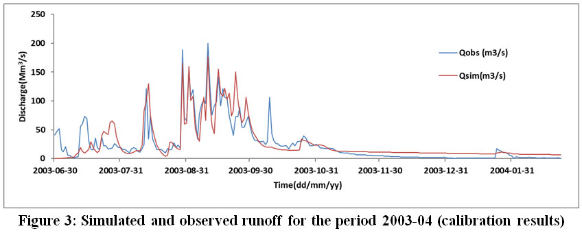 |
Figure 3: Simulated and observed runoff for the period 2003-04 (calibration results) Click here to view Figure |
 |
Figure 4: Accumulatedsimulated and observed runoff for the period 2003-04 (calibration results) Click here to view Figure |
Model Validation
Validation of the model means that the developed model can be applied appropriately not only in calibration data period but also in another time periods. In this study, the effective model parameters are obtained from the calibration processes.
Daily time series data from 2005 to 2009 have been used for model checking i.e. for the model validation. The daily runoff was simulated using rainfall from 2005 to 2009. Figure 5 presents the computed daily runoffofArpabasin during 2005–2006. The observed and simulated accumulated runoff plot (Figure 6) indicates that the developed model is able to define the runoff generation process of the selected basin.
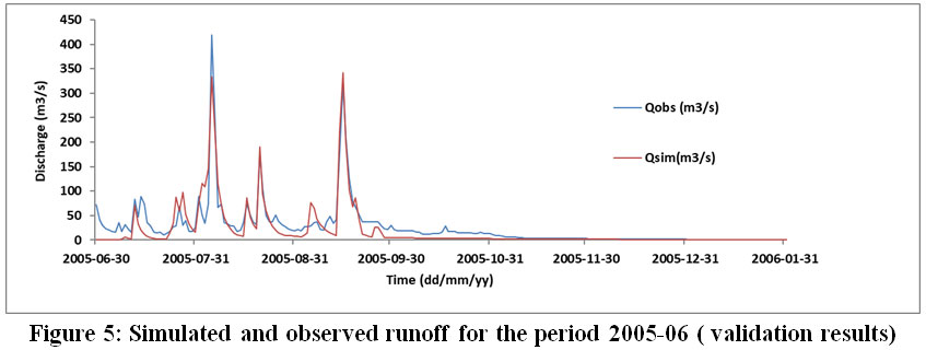 |
Figure 5: Simulated and observed runoff for the period 2005-06 ( validation results) Click here to view Figure |
 |
Figure 6: Accumulated simulated and observed runoff for the period 2005-06 (validation results) Click here to view Figure |
Accuracy Criteria
The accuracy of the developed MIKE11NAM model has been evaluated by the coefficient of determination and EI. The Efficiency Index (EI) obtained during this study was 0.63 in calibration and 0.61 in validation (Table 2). Coefficient of determination is obtained as 0.76 during calibration and 0.73 in validation. The Root Mean Square Error (RMSE) is computed for determining the accuracy of MIKE 11NAMmodel which defines absolute error between the observed and computed runoff. In this study, the RMSE value was obtained as 22.74 in calibration and 27.13 in validation. The values of NS Efficiency Index, RMSE and coefficient of determination suggested that the observed and simulated runoff are in good agreement. Model is able to capture most of the peek flows particularly during validation, however during calibration, some of the peak flows are not properly captured by the developed model. Uncertainty in data input may be one of the reasons for this. It has been observed that the model is capable to capture flow hydrograph more accurately for the period mid-June to mid-September (monsoon season) while pre-monsoon and post-monsoon simulations showing the difference from observed flows. However, the model gives good matching of accumulated observed and simulated runoff which provides a very good estimate of total water availability in the basin.
Table 2: Performance of the MIKE 11 NAM Model
|
Model Performance Indices |
NAM Model Calibration |
NAM Model Validation |
|
Coefficient of determination |
0.76 |
0.73 |
|
Root Mean Square Error |
22.74 |
27.13 |
|
NS Efficiency Index |
0.63 |
0.61 |
|
Water balance |
2.23 |
-7.14 |
Conclusions
The runoff estimation for the Arpa basin of Seonath river is hoped to contribute to the hydrological analysis, water resources development and management and it also solve the water sharing problems. In this study, the rainfall runoff was successfully modelled using MIKE11NAM. Acceptable results were obtained during calibration and validation as confirmed from R2, EI, RMSE and water balance values. This study demonstrates the usefulness of NAMMIKE11 for the daily runoff simulation. Furthermore, the developed model can also be used to generate runoff series for future scenarios and thus for developing a decision support system for management of water resources.
Acknowledgements
Authors acknowledge the support provided by Director, NIH. The funding received from NIH is duly acknowledged.
Conflict of Interest
The Author(s) declare no conflict of interest.
References
- Agarwal, A., Lohani, A.K., Singh, R.D., Kasiviswanathan, K.S. Radial Basis Artificial Neural Network Models and Comparative Performance. Journal of Indian Water Resources Society. 2013;33 (4):1-8.
- Kar A.K., Lohani A.K. Goel N.K., Roy G.P. Development of Flood Forecasting System using Statistical and ANN Techniques in the Downstream Catchment of Mahanadi basin. India, Journal of Water Resource and Protection (JWARP) .2010. 2(10):880-887.
CrossRef - Kar A.K., Lohani A.K., Goel, N.K., Roy G.P. Rain gauge network design for flood forecasting using multi-criteria decision analysis and clustering techniques in lower Mahanadi river basin, India Journal of Hydrology: Regional Studies.2015. 4 (Part B):313-332.
CrossRef - Kar A.K., Lohani A.K., Goel N.K., Roy G.P. Development of a Fuzzy Flood Forecasting Model for Downstream of Hirakud Reservoir of Mahanadi Basin, India. In: Sharma N. (eds) River System Analysis and Management. Springer, Singapore. 2017. 211-218.
CrossRef - Lohani AK., Goel NK., and Bhatia KKS. Real-time flood forecasting using fuzzy logic. Hydrological Perspectives for Sustainable Development, Volume I, Eds. M. Perumal, Allied Publishers Pvt. Ltd., New Delhi.2005.168-176.
- Lohani A.K., Goel N.K., and Bhatia K.K.S. Development of fuzzy logic based real-time flood forecasting system for river Narmada in Central India. in International Conference on Innovation Advances and Implementation of Flood Forecasting Technology, www.Actif.cc.net/conference2005/proceedings.ACTIF/Floodman/Flood Relief, October, Tromso, Norway, 2005.
- Lohani A.K., Goel N.K., and Bhatia K.K.S. Takagi-Sugeno fuzzy inference system for modelling stage-discharge relationship. Journal of Hydrology. 2006; 331:146-160.
CrossRef - Lohani A.K. Goel N.K. Bhatia K.K.S. Deriving stage–discharge–sediment concentration relationships using fuzzy logic. Hydrological Sciences–Journal. 2007; 52(4):793-807.
CrossRef - Lohani A.K. Goel N.K. and Bhatia K.K.S. Reply to comments provided by Z. Sen on Takagi–Sugeno fuzzy system for modelling stage-discharge relationship by A.K. Lohani, N.K. Goel and K.K.S. Bhatia. Journal of Hydrology.2007; 337(1-2):244-247.
CrossRef - Lohani, A.K., Kumar Rakesh, Singh R.D.Hydrological Time Series Modeling: A Comparison Between Adaptive Neuro-Fuzzy, Neural Network and Auto Regressive Techniques. Journal of Hydrology, Elsevier.2012; 442-443 (6), 23-35.
CrossRef - Lohani, A.K., Goel, N.K., Bhatia, K.K.S. Rainfall-Runoff Modelling Using Fuzzy Rule-Based Approach. International Conference on Water, Environment, Energy and Society (WEES). Hydrologic and Hydraulic Modelling. 2009; I:257–263.
- Lohani, A.K., Goel, N.K., Bhatia, K.K.S. Comparative study of the neural network, fuzzy logic and linear transfer function techniques in daily rainfall-runoff modelling under different input domains. Hydrological Processes.2011; 25:175–193.
CrossRef - Lohani A.K, Goel N.K. and Bhatia K.K.S. Improving real-time flood forecasting using fuzzy inference system. Journal of Hydrology. 2014; 509(13):25–41.
CrossRef - Green W.H., AmptG.A. Studies on Soil Physics. 1. The Flow of Air and Water Through Soils. Journal of Agriculture Science. 1911; 4:1-24.
- McPherson M.B. Some notes on the Rational Method of Storm Drain Design, Tech.Memo. No.6. ASCE, Water Resources Research Program, Harvard University, Cambridge. 1969.
- Maidment D.R. Handbook of Hydrology, 1st Edition. NewYork. McGraw Hill, Inc, 1993; 3-19.
- Chatterjee C., Jha R., Lohani A.K., Kumar R., Singh R. Estimation of SCS Curve Numbers for a Basin using rainfall-runoff Data, ISH Journal of Hydraulic Engineering. 2002;. 8(1):40-49.
CrossRef - Kumar R., Chatterjee C, Lohani A.K., Kumar S., Singh R.D., Sensitivity Analysis of the GIUH based Clark Model for a Catchment, Journal of Water Resources Management, The Netherlands. 2002; 16:263-278.
CrossRef - Kumar R., Chatterjee C., Singh R.D., Singh R.D., Lohani A.K., Nema R.K. Flood estimation for ungauged catchments using GIS and GIUH based Nash model, Asian-Pacific Remote Sensing and GIS Journal, 2003; 15:11-20.
- Kumar R., Chatterjee C, Singh R.D., Singh R.D., Lohani A.K., Kumar S., GIUH based Clark and Nash models for runoff estimation for an ungauged basin and their uncertainty analysis. International Journal of River Basin Management. 2004; 2(4):1-11.
CrossRef - Kumar R., Chatterjee C, Singh R.D., Singh R.D., Lohani A.K., Kumar S. Runoff Estimation for an ungauged catchment using Geomorphological Instantaneous Unit Hydrograph (GIUH) Models. Hydrological Processes. 2007; 21:1829-1840.
CrossRef - Bergstrom S.The HBV model. Computer Models of Watershed Hydrology. Water Resources Publications, Colorado.1995; 443–476.
- Burnash R.J.C. The NWS river forecast system - catchment modelling. Computer Models of Watershed Hydrology. Water Resources Publications, Colorado.1995; 311–366.
- Sugawara M. Tank model. Computer Models of Watershed Hydrology, Water Resources Publications, Colorado. 1995; 165–214.
- Kumar R., Chatterjee C, Kumar S., Jain S.K., Lohani A.K., Singh R.D.Intercomparison of the response of HEC-1 package and Nash Model, Hydrology Journal, 2001. 24(3).
- Kumar R., Chatterjee C, Kumar S., Lohani A.K., Singh R.D. Estimation of Direct Surface Runoff Hydrograph for a basin using HEC-1 Package and Nash Model Journal of the Institution of Engineers (India). Civil Engineering Division.2002; 82:181-185.
- Lohani A.K., Singh R., Srinivas B. Optimisation of Clark's Unit Hydrograph using HEC1 with support of GIS, Journal of The Institution of Engineers (India). Civil Engineering Division. 2003; 83:252-258.
- Nielsen S.A., Hansen E., Numerical simulation of the rainfall-runoff process on a daily basis. Nordic Hydrol. 1973; 4:171–190.
CrossRef - Havno K., Madsen, M.N.,Dorge, J., MIKE 11 - A generalized river modelling package. Computer Models of Watershed Hydrology, Water Resources Publications, Colorado, 1995; 733–782.
- Bhat S. J. A, Maqbool Geelani S., Haq S, Hanifa Geelani S. Studies on the forest types available around Arpa River watershed in Chhattisgarh. Journal of Plant Science Research. 2013; 29(1): 69-71.
- A Modelling System for Rivers and Channels-Reference ManualMIKE 11, DHI, Denmark. 2017.
- Lohani A.K. Hydrological data collection processing and analysis, Report No. SR-27, National Institute of Hydrology, Roorkee. 1993.
- Lohani A.K., Chowdhary H, Singh R.D. Use of GIS-based HYMOS for surface water data processing,, Spatial Information Technology-Remote Sensing and Geographical Information Systems, BS Publications, Hyderabad, India. 2000.
- Lohani A.K., Kumar R., Chatterjee, C. Computer-based surface water data processing techniques and tools, Impact of Information Technology on Quality of Life- Future Strategy. Proceedings of the 16th National Convention of Computer Engineers, The Institute of Engineers (India) Bihar State Centre. 2001; Dec 15-16:137-143.
- Lohani A.K., Singh, R.D. Kumar R. Application of HYMOS for processing gauge and discharge data. Workshop on Establishment of Water Resources Data Processing and Data Storage Centres, 17-19 Feb 2004, State Water Resources Agency, Govt. of Uttar Pradesh, Lucknow.2004; 73-84.
- Lohani A.K., Singh, R.D., Kumar R. Rainfall data processing using HYMOS, Workshop on Establishment of Water Resources Data Processing and Data Storage Centres, 17-19 Feb 2004, State Water Resources Agency, Govt. of Uttar Pradesh, Lucknow. 2004; 85-91.
- Nash, J. E., Sutcliffe, J. V. River flow forecasting through conceptual models. Part-1, A Discussion on Principals. Journal of Hydrology. 1970. 10:282-290.
CrossRef - Fleming, G. Computer simulation techniques in hydrology. New York: Elsevier.1975; 18-53.


