Climate Change Impacts on Hydrology and Water Resources of Indian River Basins
Umesh Kumar Singh
*
 and Balwant Kumar
http://dx.doi.org/10.12944/CWE.13.1.04
Copy the following to cite this article:
Singh U. K, Kumar B. Climate Change Impacts on Hydrology and Water Resources of Indian River Basin. Curr World Environ 2018;13(1). DOI:http://dx.doi.org/10.12944/CWE.13.1.04
Copy the following to cite this URL:
Singh U. K, Kumar B. Climate Change Impacts on Hydrology and Water Resources of Indian River Basin. Curr World Environ 2018;13(1). Available from: http://www.cwejournal.org?p=1071/
Download article (pdf)
Citation Manager
Publish History
Introduction
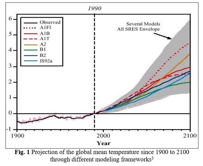
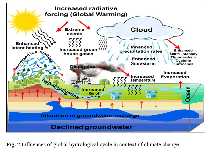
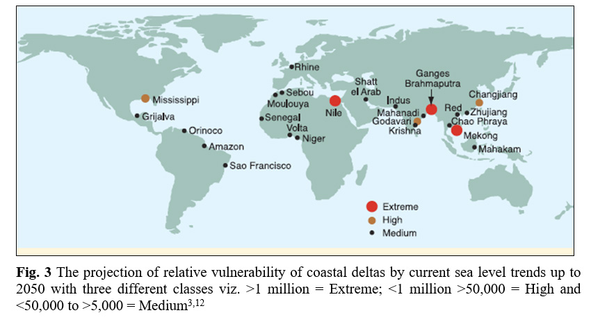
In the last few decades, increased level of carbon dioxide and radiative trace gases in the atmosphere has been observed which induce the climate change and greenhouse warming to the world.1 The global average surface temperature has increased significantly in last 100 years. The projection of many studies has confirmed that in next 100 years the earth will experience with high surface temperature.2 In the present scenario, various environmental components such as physical and biological systems in different continents are severely affected by recent climatechange(Fig. 1).3 Several studies around the world confirm that anthropogenic greenhouse gas emission is changing the average global temperatures (increased about 0.6 0C) which are altering the global hydrological cycle that affects almost every aspect of human life.1,4,5 The hydrological cycle is an important component of the worldwide climate system which plays an essential role in the redistribution of sun’s energy throughout the globe in the form of latent heat flux6. However, the modification in the global hydrological cycle due to climate change, drought, flood, changes in rainfall pattern, extreme weather events and alteration in river flow and groundwater recharge (Fig. 2) have been observed in various part of the world.7,8 The consequences of climate change; sea level raised ~10 to 20 cm and ~40% of Arctic sea ice has melted just within 40-50 years. Also, since 1936 to 1999, the annual discharge of six largest Eurasian rivers has increased ~7% to the Arctic Ocean.3 Some reports also showed that 4% global runoff increases by 1 °C global temperature rise9.Consequently; global mean sea level has risen up to~0.09 to 0.88 meter since the start of the twentieth century10.Additionally, climate change has already impacted on the various mega-deltas particularly due to sea-level rise and changes in runoff3.It is estimated that around 300 million people live in the 40 mega-deltas globally. Ganges-Brahmaputra delta is having high population density (500 people/km2) and one of themost densely populated deltas of the world11.However, the mega-deltas including the Ganges-Brahmaputra in Bangladesh, the Mekong in Vietnam and the Nile in Egypt are most vulnerable deltas of world (Fig. 3).3,12 Some study also indicated that around one million people of these mega-deltas will be directly affected by 2050 due to sea level rise and coastal erosion, land loss and flooding.12
In recent times, several studies in India have shown that climate change is likely to impact on freshwater resources by an alteration in rainfall pattern, rising surface temperature, changes in groundwater recharge, the timing of surface runoff and increased evaporation. The rising surface temperature of the Indian subcontinent by 0.48 0C has been observed over the last century.13 The alteration in the rainfall pattern has been observed in India where mean value of five year rainfall deviated from 6 to 15% than the normal rainfall pattern.14 Furthermore, the deviations in annual mean surface runoff over the Indian subcontinent has also been observedand concluded that the estimated annual discharge would increase up to ~ 25% by 208015.These reports indicate that climate change has largely influenced the water resources of the Indian subcontinent. However, in developing country like India, water demand for various sectors such as domestic, industrial and agricultural uses, has already increased in last few decades.16 In India, several major and minor rivers are the greatest strength of freshwater resources that fulfil the water demands for agriculture, domestic and industrial purposes17. The annual flow of Indian rivers is about 1880 km3/year in which only 36% of the total flow is utilized to fulfil the water demands for agriculture, domestic and industrial purposes18. However, India holds ~17.5% of the total global population where per capita water availability was 1820 m3/person/year in 200119.Consequently, the expansion of agricultural sectors, land use pattern, development of industrial and urban centres are modifying the hydrological cycle, resulting in the per capita water demand of 1341 and 1140 m3/person/year by 2025 and 2050 respectively.20 These uncertainties show that India would develop into the water-stressed country in the recent future.Therefore, present study is based on the given expected changes due to climate change over the Indian River basins and has been reviewed with studying the topography of river basin, water availability, climatic and hydrological condition. In this study, we have tried to summarise the previous studies related to Ganges-Brahmaputra-Meghna (GBM) river basins keeping in view that how the climate has changed in these river basins in recent times.
Indian River Basin
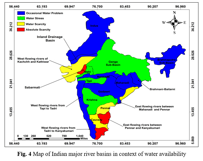
In India, Himalayan range is the greatest source of pure water in the form of snow that melts and transverses through 45,000 km long riverine networks.21 There are thirteen major river basins (Fig. 4) in India which occupy around 83% of total drainage basin area with 85% of total surface flow and about 80% of Indian people reside in this area.22 Also, twenty major rivers, and several minor rivers fulfil the water demands for agriculture, domestic and industrial purposes, which is greatest strength of Indian freshwater resource.17 Major river basins like the Indus, the Ganges and the Brahmaputra and their associated tributaries represent about 50% of India’s fresh water resources.23 Presently, various Indian River basins like Ganga, Mahi, Tapi, Krishna, Pennar, Cauvery, Kachchh, and Kathiawar are under water stress condition due to over-exploitation and climate change (Fig. 2).24 These river basins have experienced a remarkable change in path, flow, water availability and reducing their self-natural purification capacity in last few decades25.Additionally, various Indian river basins are experiencing with minimal per capita water availability which is mainly due to considerable spatial variation in rainfall.26 The consequence of these changes due to global climate changes and water needs may create serious problem including loss of biodiversity and aquatic system, local and regional water availability as well as humans from water shortage and flooding.27
The Ganga River Basin
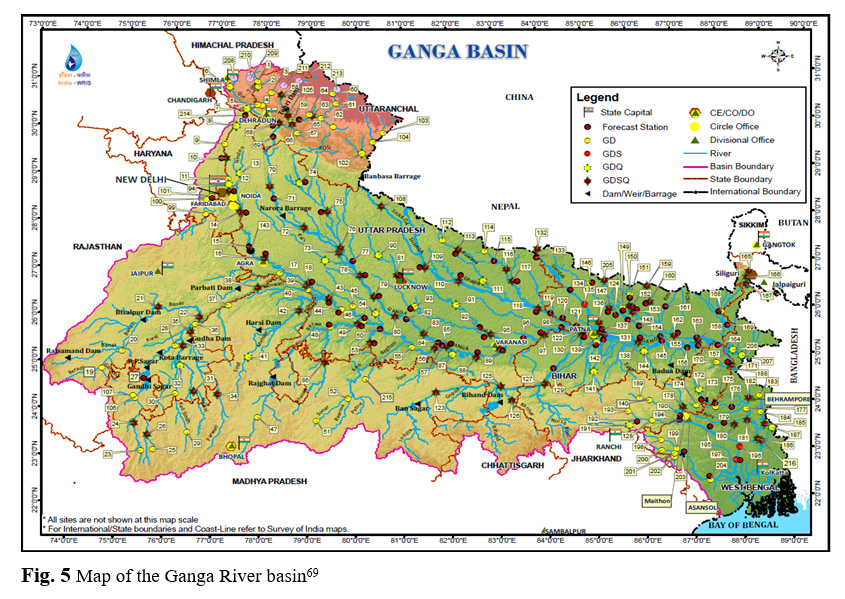
Ganga is the largest Indian river which extends between the latitude of 220 30’N to 310 30’N and the longitude of 730 0’E to 890 0’E (Fig. 5) and traverses a length of about 2550 km with a total catchment area of 1087300 km2 in India and Nepal. The River originates from Gangotri glacier (Himalaya) at an elevation of 7010 m above mean sea level and drain through Indian states of Uttarakhand, Uttar Pradesh, Madhya Pradesh, Bihar, Jharkhand and West Bengal before submerging into the Bay of Bengal.28 The Ganga plains are one of the most densely populated areas due to the availability of drinking water, fertile soil and suitable landscapes. Ganga River associated with some tributaries play an important role in the formation of most fertile alluvial plain. In the Gangetic plains, the area of Uttarakhand , Uttar Pradesh, Bihar and West Bengal represent a very large population of India. Nearly 670 million people and almost one-tenth of the world's population live in the plains of Ganga.29
Many recent studies have examined the increasing trend in temperature, hydrological processes, ecosystems, and water resources due to effects of climate change in Ganga Basin. Shrestha et al., (1999) reported that since 1978 to 1994, the temperature has increased 0.06 0C/year in Nepal region.30. Furthermore, a study reported by Nepal (2012) revealed that the highest increase rate of temperature (0.05 0C/y) was observed in the Koshi region, a sub-basin of the Ganges.31 The similar study has been done by Liu and Chen (2000) and they have found that the temperature has increased about 0.16 0C per decade between 1955 and 199632. The maximum temperature trends have been observed in Nepal (Central Himalayan region)30. The projected future model showed that the annual temperature of this region would increase about 0.06 0C/y between 2000 and 210033. However, Arora and Boer (2001) have reported that mean annual runoff of the River Ganga will increase about 5% by 2070 – 210034. A similar study has been conducted by Miller et al., (2012) which suggests that the River Ganga will become a seasonal river in recent future.35 The annual precipitation over the Ganges Basin shows that monsoon precipitation has increased about 10 to 12.5%, especially in Koshi catchment.36,37 Similarly, a study by Immerzeel et al.,(2010) showed that the precipitation had increased 8% especially in upstream of the Ganga Basin.38 Overall, various projected data indicate that the monsoon precipitation might increase in the Ganga Basin in future.
The Brahmaputra River Basin
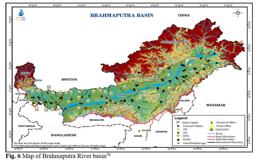
The Brahmaputra River also originates from the Himalaya (Kailash ranges) which transverses east through the southern part of China and enter into eastern India and lastly joins with the River Ganga in Bangladesh.39 In the journey, the river flows eastwards for 1130 km then enters in the Arunachal Pradesh followed by Assam and Meghalaya (India) for another 650 km and lastly enters Bangladesh (Fig. 6). The length of the Brahmaputra River is about 2840 km with having a total area of 5, 80,000 square kilometre.40 The large portion of the river basin is covered with forest which is about 55.48% of the total area. In the upper part of Brahmaputra River discharge mostly comes from the snowmelt before it enters Arunachal Pradesh. However, after it enters into the Indian states of Arunachal Pradesh, Assam, and Meghalaya, river experiences with heavy rainfall which contributes substantially to the river flow. Consequently, river basin experiences with alteration in flow transport of sediment and channel configuration.41 However, in the rainy season, floods are a common phenomenon in the plain areas of India due to heavy discharge of Brahmaputra River.42
However, not many studies have been carried out in context of the vulnerability of climate change on Brahmaputra basin as compared to Ganga River basin35. Some previous studies revealed that the average annual temperature of Brahmaputra basin has increased notably in last few decades.43,44,45 Flugel et al., (2008) have observed that since 1961 to 2005, the average temperature of the upper Brahmaputra River basin has increased by 0.28 0C per decade.43 Furthermore, the study by Immerzeel (2008) showed that the temperature had increased about 0.68 0C per 100 years from 1900–2002, especially in the spring season.44 The extensive physical assessment of the Brahmaputra River basin has been carried out by Mahanta et al., (2014).45 The authors studied the possible climate change impacts on temperature, evapotranspiration, rainfall, and river flows in the basin. They expected that the temperature might increase from 1.3 0C to 2.4 0C by 2050, followed by 2.0 0C to 4.5 0C by 2100 in the Brahmaputra River basin. Similarly, they suspected that the monthly evapotranspiration is likely to increase 5% to 18% by 2050 followed by 7% to 36% by 2100. The alteration in average monthly rainfall has also been observed by researchers through a future projected model which suggests that the variation in rainfall to be 14% decrease to 15 % increase by 2050 and 28 % decrease to 22 % increase by 2100 respectively.45 The overall result justified by authors showed that climate change might be responsible for the alteration in the physical characteristics of Brahmaputra River basin shortly.
|
|
|
|
|
|
|
|
|
Impact of Climate Change on the Hydrological Regime of GBM System
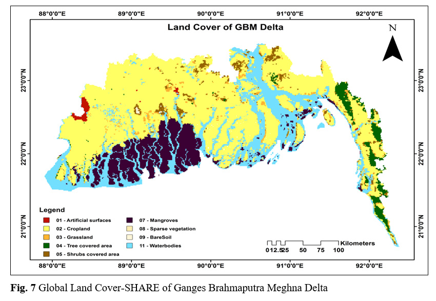
India has a long riverine network system which mainly belongs to Himalayan river system and draining to the major plains of the country. The Ganga-Brahmaputra-Meghna (GBM) is the trans-boundary river basin which covers over 1.7 million Km2. The total area of the GBM rivers distributed between five different countries which include India (63%), China (18%), Nepal (9%), Bangladesh (7%) and Bhutan (3%) and ultimately drain into the Bay of Bengal.46 The headwaters of Ganges and Brahmaputra River originate in the Himalayan mountain range in China.47 The Meghna originates from the Manipur hills, India and enter into Bangladesh associated with Surma and Kuchiyara Rivers. Subsequently, the Meghna joins with Ganges and Brahmaputra in the Chandpur and lastly drains into the Bay of Bengal48.The GBM River basins support the lives and livelihoods of some 700 million people,and currently, basins have been widely utilized for drinking, irrigation, navigation, industry and hydropower generation purposes.49 These basins extend across multiple countries, resulting river basins have experienced with different climate and flow regimes, influenced to a large extent by the summer and winter monsoons. The GBM delta is the second world largest delta which has spread over the Bengal basin of the South Asian region (Fig. 7) and third largest freshwater outlet to the world’s oceans.50 These rivers in the Bengal basin are spread over the coastal zone and offshore areas. However, these rivers carry an enormous amount of water and sediments (109t/year) which is responsible for forming and enlarging the Ganges delta51. The combined outfall of the GBM Rivers also plays an essential role including surface and groundwater recharge, reducing saltwater intrusion, and increasing soil fertility.52 GBM basin flow is strongly influenced by the melt of snow. However, the temperature has increased in last few years, which has induced the rate of melting of glacial and snow. Consequently, summer flows of some river systems may increase followed by are duction in flows as the glaciers disappear and snow diminishes.38 Also, some study also suspects that every populated basin in India such as Ganga-Brahmaputra-Meghna (GBM) is more vulnerable to water stress and alteration in river discharge.
|
|
|
|
|
Figure 5: Map of the Ganga River basin69 |
However, some studies have revealed that climate change significantly affects the hydrology and water resources of the GBM basins which might be responsible for more severe floods and drought problem in recent time.53 The climate change is already inducing the combined effect of glacier melt and extreme monsoon rainfall over the GBM river basins, which may be responsible for the rise of sea level.54 The consequences of climate change over the GBM river basin includes more intense rains, alteration in the spatial and temporal distribution of rainfall, higher runoff, low groundwater recharge and changes in evaporative demands.55 These impacts on GBM river basins could also influence the agricultural production, food security, and biodiversity as well as water security for Indian subcontinents56. The delta regions of GBM river basin in Bangladesh and India are particularly vulnerable to future climate change.57
Shamsudduha et al., (2009) observed that groundwater levels in the GBM delta had declined more than 1 m/yr continuously from 1985 to 200558. Furthermore, Kamal et al., (2013) have carried out the seasonal variability of monsoon and dry periods through projected data of the period of 2020s, 2050s, and 2080s. The results signify that the peak flow of GBM rivers may enhance about 4.5 - 39.1% in monsoon period while in the dry period, low flows may decline by 4.1- 26.9% which reveals high seasonal variability as a result of climate change59. Masood et al., (2015) suspected that by the end of 21st-century entire GBM basin would be warmed by three degree celsius. Also, researchers have projected that the changes in mean precipitation more than 15.2 % and alteration in mean runoff more than 18% could occur in GBM River basin by the end of 21st century.60 Similarly, Whitehead et al., (2015) conducted the study on GBM River basin sbased on the future climate model for 2050s and the 2090s. The results indicate a significant increase in monsoon flow under the future climate with enhanced flood potential. Authors have also predicted the low flows and extended drought periods over GBM basin, which could impact on water and sediment supply, irrigated agriculture and saline intrusion.29
Consequences of Climate Change over GBM Delta
The GBM delta is the second largest in the world which plays an important role in South East Asia to fulfil the needs of hundreds of millions of people, including many large and growing cities.61 However, in the present scenario, physical environmental changes have been observed throughout GBM delta region due to climate change including several reservoir creations, dredging and channeling to control water availability. Also, high erosion during an extreme event like Sidr cyclone in 200762, a slightly less net gain of land in the Bangladesh part45 and a net loss of land in Sundarban mangroves63 have been observed in the last few decades. Furthermore, during the 20th century, the rate of sea level rise has significantly (0.07 inch/year) increased whereas the local sea-level rise of about 1 inch per year has been noted in GBM Delta.64 Some studies also revealed that most of the deltaic plains of Ganges, Brahmaputra, and Meghna have an elevation of less than 16 feet.65 Consequently, in coming years, people living on this delta may face the threat of rising sea levels.66 This region could also experience severe flooding as a result of melting of snow and glaciers.67 The previous studies estimated that rising of sea-level in the GBM delta could directly affect more than 3 million people and lose nearly one-quarter of the land area.66 Similarly, disaster risks like high exposure to floods and droughts, reduction of sediment supply and alteration in water flow due to dams and abstractions in the GBM delta could increase in the next 15-30 years and might be responsible for the sinking of deltas. Consequences of these changes over GBM delta are also likely to face growing water stress in different countries viz. India, China, Bangladesh, Bhutan, Myanmar,and Nepal.68
|
|
|
|
|
|
Conclusion
The review has provided information about the climate change and their consequences over the water resources. The previous studies mainly signify the changes in river flows, melting of ice, precipitation, and temperature through different models. Several studies have indicated that due to climate change, global temperature has increased significantly in last century and it will increase rapidly in next 100 years.In the present scenario, climate change has impacted on annual discharge of rivers, global runoff, global temperature, global mean sea level, and various mega-deltas.The mega-delta like Ganges-Brahmaputra-Meghna (GBM) delta is one of the most vulnerable deltas of world in context of climate change.The remarkable change in GBM basin climate is likely to have a significant impact on its rivers, which could enhance the flooding potential and drought problem. These impacts on GBM river basin could also influence the agricultural production, food security, and biodiversity as well as water security for Indian subcontinents. The situation may become worse if it is associated with global warming and accelerated sea level rise. However, the assessment of climate change impact on water resources is still subject to considerable uncertainty. Therefore, it is essential to get more details about the long-term observations of climate variables in water resources to improve regional climate models and the climate projections.
Acknowledgments
Authors would like to thank University Grants Commission (UGC), Government of India (F. No. 42- 437/2013 (SR)), for a financial grant through major research project. We wish to thank the editor and the anonymous reviewers for their suggestions and critical comments.
References
-
Jiang T., David Y., Xu C., Chen X., Singh V. P., Chen X. Comparison of hydrological impacts of climate change simulated by six hydrological models in the Dongjiang Basin, South China. Journal of hydrology. 2007;316–33.
CrossRef -
IPCC., W. G. I. IPCC Special Report on Emissions Scenarios. IPCC, Geneva. 2001.
-
IPCC, Climate Change: Impacts, Adaptation and Vulnerability. Contribution of Working Group II to the Fourth Assessment Report of the Intergovernmental Panel on Climate Change, M.L. Parry, O.F. Canziani, J.P. Palutikof, P.J. van der Linden and C.E. Hanson, Eds. Cambridge University Press, Cambridge, UK. 2007;976.
-
Dibike Y. B., Coulibaly P. the Hydrologic impact of climate change in the Saguenay watershed : comparison of downscaling methods and hydrologic models. Journal of Hydrology. 2005;307:145–63.
CrossRef -
Mall R. K., Gupta A., Singh R., Singh R. S., Rathore L. S. Water resources and climate change: An Indian perspective. Current Science. 2006;90:1610–1626.
-
Khan A., Chatterjee S. Climate Change and Hydrology in Indian Perspectives. Jacobs Journal of Hydrology. 2015;1(1).
-
Arnell N. W. Climate change and global water resources: SRES emissions and socio-economic scenarios. Global Environment Change. 2004;14:31–52.
CrossRef -
Huntington T. G. Evidence for intensification of the global water cycle: review and synthesis. Journal of Hydrology. 2006;319:83–95.
CrossRef -
Levitus S., Antonov J. I., Wang J., Delwotrh T. L., Dixon K. W., Broccoli A. J. Anthropogenic warming of Earth’s climate system. Science. 2001;292:267–70.
CrossRef -
Mall R. K., Bhatla R., Pandey S. N. Water resources in India and impact of climate change, Jalvigyan Sameeksha. 2007;22:157-176.
-
Dandekar P. Shrinking and Sinking Deltas: Major role of Dams in delta subsidence and effective sea level rise. South Asia Network on Dams Rivers and People. 2014;1-14 .
-
Ericson J. P., Vorosmarty C. J., Dingman S. L., Ward L. G., Meybeck M., Effective sea-level rise and deltas: Causes of change and human dimension implications. Global Planetary Change. 2005;50:63-82.
CrossRef -
Houghton J. T., Meiro Filho L. G., Callendar B. A., Harris N., Kattenburg A., Maskell K. (Eds.) Climate Change 1995: The Science of Climate Change. Cambridge University Press, Cambridge, UK. 1996;572.
-
Thapliyal V., Kulshreshtha S. M. Climate changes and trends over India. Mausam. 1991:42:333–338.
-
Lal M., Chander S. Potential impacts of greenhouse warming on the water resources of the Indian subcontinent. Journal of Environmental Hydrology. 1993;3:3-13.
-
Hinrichsen D., Tacio H. The coming freshwater crisis is already here. The linkages between population and water. Washington, DC: Woodrow Wilson International Center for Scholars. 2002;1-26.
-
Lal M. Implementations for Indian water resources. Journal of Indian Water Research Society. 2001;21:101-119.
-
CWC (Central Water Commission), Water and Related Statistics. New Delhi. 1995.
-
Manoj K., Padhy P. K. Discourse and Review of Environmental Quality of River Bodies in India: An Appraisal of Physico-chemical and Biological Parameters as Indicators of Water Quality. Current World Environment. 2015;10.
-
Hegde N. Water Scarcity and Security in India: A Presentation by Narayan Hegde, BAIF at the Indian Science Congress 2012, http://www.indiawaterportal.org/node/23240, Accessed on 01.01.2018, 2012.
-
Suthar S., Nema A. K., Chabukdhara M., Gupta S. K. Assessment of metals in water and sediments of Hindon River, India: Impact of industrial and urban discharges. Journal of Hazardous materials. 2009;171(1-3):1088-95.
CrossRef -
Bhardwaj R. M. Water Quality Monitoring in India-Achievements and Constraints, IWG Env, International Work Session on Water Statistics, Vienna, (2005).
-
Lal M. Climatic change-implications for India's water resources. Journal of Social and Economic Development. 2000;3:57-8.
-
Gaur A., Amerasinghe P. A. river basin perspective of water resources and challenges. India Infrastructure Report. 2011.
-
Gosain A.K., Rao S., Basuray D. Climate change impact assessment on hydrology of Indian river basins. Current science. 2006;346-35.
-
Amarasinghe U. A., Sharma B. R., Aloysius N., Scott C., Smakhtin V., de Fraiture C. Spatial variation of water supply and demand across river basins of India. Research Report 83. Colombo, SriLanka: International Water Management Institute. 2005.
-
Chang H., Bonnette M. R. Climate change and waterâ€related ecosystem services: impacts of drought in California, USA. Ecosystem Health and Sustainability. 2016;2(12).
-
Whitehead P. G., Sarkar S., Jin L., Futter M. N., Caesar J., Barbour E. Dynamic modeling of the Ganga river system : impacts of future climate and socio-economic. Environmental Science: Processes & Impacts. 2015;1082-1097.
CrossRef -
Whitehead P. G., Barbour E., Futter M. N., Sarkar S., Rodda H., Caesar J. Impacts of climate change and socio-economic scenarios on flow and water quality of the Ganges, Brahmaputra and Meghna (GBM) river systems: low flow and flood statistics. Environmental Science: Processes & Impacts. 2015;17(6):1057-1069.
CrossRef -
Shrestha A. B., Wake C. P., Mayewski P. A., Dibb J. E. Maximum temperature trends in the Himalaya and its vicinity: an analysis based on temperature records from Nepal for the period 1971–94. Journal of climate. 1999;12(9),2775-86.
CrossRef -
Nepal S. Evaluating Upstream-down stream Linkages of Hydrological Dynamics in the Himalayan Region. PhD. Thesis. Friedrich Schiller University of Jena, Jena. 2012.
-
Liu X., Chen B. Climatic warming in the Tibetan Plateau during recent decades. International Journal of Climatology. 2000;20:1729–1742.
CrossRef -
Immerzeel W. W., Beek L. P. H., Konz M., Shrestha A. B., Bierkens M. F. P. Hydrological response to climate change in a glacierized catchment in the Himalayas. Climatic Change, 2012;110:721–736.
CrossRef -
Arora V. K., Boer G. J. Effects of simulated climate change on the hydrology of major river basins. Journal of Geophysical Research. 2001;106,3335–3348.
CrossRef -
Miller J. D., Immerzeel W. W., Rees G. Climate change impacts on glacier hydrology and river discharge in the Hindu Kush-Himalayas: a synthesis of the scientific basis. Mountain Research and Development. 2012;32(4):461–467.
CrossRef -
Sharma K. P., Moore B., Vorosmarty C. J. Anthropogenic, climatic, and hydrologic trends in the Kosi Basin, Himalaya. Climatic Change. 2000;47 141-65.
CrossRef -
Pervez M. S., Henebry G. M. Projections of the Ganges–Brahmaputra precipitation-down scaled from GCM predictors. Journal of Hydrology, 2014;517:120–134.
CrossRef -
Immerzeel W. W., Van Beek L. P. H., Bierkens M. F. P. Climate change will affect the Asian water towers. Science. 2010;328:1382–1385.
CrossRef -
Devi H., Goswami P. Analysis of effect of climate change of rainfall, temperature and discharge on River Brahmaputra. International Journal of Innovative Research in Advanced Engineering, 2015;2(4):172–7.
-
Priya S., Young W., Hopson T., Avasthi A. Flood Risk Assessment and Forecasting for the Ganges-Brahmaputra-Meghna River Basins. 2017.
-
Goswami D. C. Brahmaputra River, Assam, India: Physiography, basin denudation, and channel aggradation. Water Resources Research. 1985;21:959–978.
CrossRef -
Nepal S., Shrestha A. B. Impact of climate change on the hydrological regime of the Indus, Ganges and Brahmaputra river basins: a review of the literature. International Journal of Water Resources Development. 2015;31(2):201-218.
CrossRef -
Flugel W. A., Pechstedt J., Bongartz K., Bartosch A., Eriksson M., Clark M. Analysis of climate change trend and possible impacts in the Upper Brahmaputra River Basin – the BRAHMATWINN Project. 13th IWRA World Water Congress 2008, Montpelier, France. 2008.
-
Immerzeel W. Historical trends and future predictions of climate variability in the Brahmaputra basin. International Journal of Climatology. 2008;28:243–254.
CrossRef -
Mahanta C., Zaman A. M., Newaz S. M. S., Rahman S. M. M., Mazumdar T. K., Choudhury R., Borah P. J., Saikia L. Physical Assessment of the Brahmaputra River. IUCN, International Union for Conservation of Nature, Dhaka, Bangladesh, Pp xii +74. 2014.
-
Hossain M. M., Zaman A. M., Ludwig F. Climate change impact on the discharge of Ganges-Brahmaputra-Meghna (GBM) River Basin. Bangladesh International Conference on Climate Change in relation to Water and Environment (I3CWE-2015). 2015.
-
Hasnain S. I. Himalayan glaciers meltdown: impact on South Asian Rivers. International Association of Hydrological Sciences. 2002;274:417-423.
-
Ovi M. M., Hossain M. S., Mahfuzul M. Geomorphic signatures of active tectonics from Sylhet city and adjoining areas Surma basin, Bangladesh. Nepal Geological Society. 2015;108.
-
Eriksson M., Jianchu X., Shrestha A. B., Vaidya R. A., Nepal S., Sandstrom K. The changing Himalayas impact of climate change on water resources and livelihoods in the greater Himalaya. Kathmandu: International Centre for Integrated Mountain Development (ICIMOD). 2009.
-
Chowdhury R., Ward N. Hydro-Meteorological variability in the greater Ganges- Brahmaputra-Meghna basins. International Journal of Climatology. 2004;24(12):1495-1508.
CrossRef -
Islam S. N. Deltaic floodplains development and wetland ecosystems management in the Ganges-Brahmaputra-Meghna Rivers Delta in Bangladesh. Sustainable Water Resources Management. 2016;2(3):237–56.
CrossRef -
Mirza M. M. Q., Warric R. A., Ericksen N. J. The implications of climate change on floods of the Ganges, Brahmaputra and Meghna rivers in Bangladesh. Climate Change. 2003;57:287–318.
CrossRef -
Mirza M. M. Q., Global warming and changes in the probability of occurrence of floods in Bangladesh and implications. Global Environment Change. 2002;12:127–138.
CrossRef -
Gain A. K., Immerzeel W. W., Sperna-Weiland F. C., Bierkens M. F. P. Impact of climate change on the stream flow of the lower Brahmaputra: Trends in high and low flows based on discharge-weighted ensemble modelling. Hydrology and Earth System Sciences. 2011;15:1537–1545.
CrossRef -
Food and Agriculture Organization of the United Nations (FAO), AQUASTAT, global water information system. Ganges-Brahmaputra-Meghna Basin. 2011. Available at: http://www.fao.org/nr/water/aquastat/basins/gbm/index.stm
-
Miyan M. A. Droughts in Asian least developed countries: vulnerability and sustainability. Weather and Climate Extremes. 2015;7:8-23:.
CrossRef -
Ahmad Q. K. Regional cooperation in flood management in the Ganges-Brahmaputra-Meghna region: Bangladesh perspective. Natural Hazards. 2003;28(1):191-198.
CrossRef -
Shamsudduha M., Chandler R. E., Taylor R. G., Ahmed K. M. Recent trends in groundwater levels in a highly seasonal hydrological system: the Ganges-Brahmaputra-Meghna Delta. Hydrology and Earth System Sciences. 2009;13(12):2373-2385.
CrossRef -
Kamal R., Matin M. A., Nasreen S. Response of river flow regime to various climate change scenarios in Ganges-Brahmaputra-Meghna basin. Journal of Water Resources and Ocean Science. 2013;2(2):15-24.
CrossRef -
Masood M., Yeh P. F., Hanasaki N., Takeuchi K. Model study of the impacts of future climate change on the hydrology of Ganges–Brahmaputra–Meghna basin. Hydrology and Earth System Sciences. 2015;19(2):747-770.
CrossRef -
Brown S., Nicholls R. J. Subsidence and human influences in mega deltas: the case of the Ganges–Brahmaputra–Meghna. Science of the Total Environment. 2015;27:362-374.
CrossRef -
Sarwar M. G., Woodroffe C. D. Rates of shoreline change along the coast of Bangladesh. Journal of Coastal Conservation. Journal of Coastal Conservation. 2013;17(3):515-526.
CrossRef -
Shearman P., Bryan J., Walsh J. P. Trends in deltaic change over three decades in the Asia-Pacific Region. Journal of Coastal Research. 2013;29(5):1169-1183.
CrossRef -
Bindoff N. L., Willebrand J., Artale V., Cazenave A., Gregory J. M., Gulev S., Hanawa K., Le Quéré C., Levitus S., Nojiri Y., Shum C. K. Observations: oceanic climate change and sea level. 2007.
-
Mohal N., Khan Z. H., Rahman N. Impact of sea level rise on coastal rivers of Bangladesh. Bangladesh: Coast, Port and Estuary Division, Institute of Water Modelling. 2006. Available: http://archive.riversymposium.com/2006/index.php?element=06MOHALNasreen.
-
Rahmstorf S., Cazenave A., Church J. A., Hansen J. E., Keeling R. F., Parker D. E., Somerville R. C. J. Recent climate observations compared to projections. Science, 2007;316(5825):709-709.
CrossRef -
Karl T. R., Melillo J. M., Peterson T. C. Global climate change impacts in the United States. U.S. Global Change Research Program. Cambridge University Press. 2009.
-
UNEP-DHI and UNEP. Trans-boundary River Basins: Status and Trends. United Nations Environment Programme (UNEP), Nairobi. Published by the United Nations Environment Programme (UNEP). 2016.
-
Water resource information system of India, The Ganga River Basin (Available at: http://india wris.nrsc.gov.in/wrpinfo/index.php?title=Ganga Accessed on (15/01/2018).
-
Water resource information system of India, The Brahmaputra River Basin (Availabe at: http://www.india-wris.nrsc.gov.in/wrpinfo/index.php-?title=Brahma-putra, Accessed on (15/01/2018).


