Mineralogical and Textural Characteristics of Soils from Sangamner Area, Ahmednagar District, Maharashtra, India
K. K. Deshmukh1 *
1
Sangamner Nagarpalika Arts, D.J. Malpani Commerce and B.N. Sarda Science College,
Sangamner,
422 605
India
DOI: http://dx.doi.org/10.12944/CWE.7.1.07
Studies were conducted to know the mineralogical and textural characteristics of soils in relation to soil fertility status of Sangamner area, Ahmednagar district, Maharashtra. For this purpose particle size distribution was determined from 62 surface soil samples collected from the area. Representative ten sample clay fractions were subjected to X-ray diffraction analysis for mineralogical characterization. Clay factions have been found to be dominated by illite which is generally facilitated due to high K2O content in soils. Montmorillonite present in the salt affected soils has the predominance of magnesium. Kaolinite, chlorite, halloysite were also detected. The textural analysis revealed the clay content varies from 9.51 to 53.61%. Clay and clay loam type of soils were found in the downstream part which is possibly attributable to inadequate drainage conditions prevailing in the area. The proportion of silt content was followed by sand and coarse sand. The textural classification of the soils showed 35.48% samples were clay, 22.58% samples were clay loam, 21% sandy clay, 16% sandy and 5 % sandy clay. This indicates that majority of the samples have clay and clay loam category. The present investigation suggested that adequate drainage and leaching, crop rotation, blending of saline water with good quality of water, use of manures and mulching and desiltation of Ojhar weir can be adapted as measures to improve soil fertility of the area. Farmer’s participation has been looked as the best means of avoiding further degradation of soils in the area.
Copy the following to cite this article:
Deshmukh K.K. Mineralogical and Textural Characteristics of Soils from Sangamner Area, Ahmednagar District, Maharashtra, India. Curr World Environ 2012;7(1):41-48 DOI:http://dx.doi.org/10.12944/CWE.7.1.07
Copy the following to cite this URL:
Deshmukh K.K. Mineralogical and Textural Characteristics of Soils from Sangamner Area, Ahmednagar District, Maharashtra, India. Curr World Environ 2012;7(1):41-48.Available from: http://www.cwejournal.org/?p=1777
Download article (pdf) Citation Manager Publish History
Select type of program for download
| Endnote EndNote format (Mac & Win) | |
| Reference Manager Ris format (Win only) | |
| Procite Ris format (Win only) | |
| Medlars Format | |
| RefWorks Format RefWorks format (Mac & Win) | |
| BibTex Format BibTex format (Mac & Win) |
Article Publishing History
| Received: | 2012-05-06 |
|---|---|
| Accepted: | 2012-06-12 |
Introduction
Soil is a dynamic and complex system of air, water, decomposing organic matter, living plants and animals. In addition to this, soil consists of rock fragments, clays, sands and silts organized into definite pattern as dictated by environmental conditions. The major factors involved in the process of soil formation are parent material, climate, time, topography and biota.1 These factors are influencing the mineralogical, mechanical and chemical properties of soils. The physical properties of the soils greatly influences its uses and behavior towards plant growth. This also influences the chemical and biological properties of the soils and it is of utmost importance in relation to plant growth as well as soil fertility.
The mineral matter is a major component of soil. The mineralogical information of soils is essential for understanding soil genesis and for developing appropriate management practices for the maintenance of soil fertility. The color of the soil is also largely caused by the presence of certain minerals. The interaction of soil clay with nutrient ions, water and organic substances determines the soil fertility, which in turn largely controlled by the quality and nature of minerals.2 Therefore, to understand the utility of soils, it is very essential to know the mineralogy. The mineralogy influences soil fertility through its control on the type and quality of plant nutrients which may be released by weathering. The shape of the particles affects their packing and thus related to soil structure.3 The study of minerals is the study of nature of soils. Many Researchers4-9 have studied the clay mineralogy of normal and salt affected soils from different parts of the country.
Texture is probably the most important of the soil characteristics. Soil texture has profound effect upon the properties of soils including its water supplying power, rate of water intake, aeration, fertility ease of tillage and susceptibility to erosion. It is a guide to the value of land. Land use capability and soil management practices are determined by the texture.10 Clays also acts as a major store of plant nutrients and therefore many aspects of soil fertility are ultimately influenced by texture.11 Voluminous research work has been conducted in the area of textural characterization of soils.12-15 The soils from the Sangamner area mainly derived from the Deccan basalts. The area is experiencing the problems of salinization, alkalinsation, waterlogging etc due to over irrigation, excess use of chemical fertilizers, intensive cultivation with modern production technology and establishment of sugarcane and allied industries. Therefore attempts have been made to study the mineralogical and textural characteristics of soils in order to know their fertility status from study area.
The Study Area
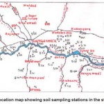
The Sangamner area is located in the Ahmednagar district of Maharashtra. Sangamner is a taluka headquarter which is located at a distance of 150 km from Pune on Pune-Nashik National Highway No. 50 (Fig.1). The area is drained by the Pravara river which is a tributory of Godavari. Pravara river originates in the mountainous region of Western Ghats and flows into low-lying fertile alluvial plain in the downstream part. Several dams and weirs have been constructed across Pravara river of these, Bhandardara dam is located in the source region and the Ozar weir is in the downstream direction of Sangamner town. These dams and weirs have been augmenting the irrigational water needs of the area. Over 90% of the study area is practising intensive agriculture. It should be noted that subsequent to the establishment of co-operative sugar-mill at Sangamner in 1967, the agriculture in the area has witnessed rapid changes in the cropping pattern. The industrial units developed in the area generate large volumes of waste water which mixes with surface and groundwater resources thereby contaminating them. At places, the lagoons used for storage of waste waters have caused degradation of soils as well as water due to infiltration of effluents. Thus, the soil resources are facing severe threat from both irrigation practices as well as from agro-based industry.
Materials and Methods
Selected 62 surface soil samples (0-20cm) were collected (Fig 1) in cloth bags as per the standard procedures.16,17 49 samples are from irrigated and 13 from non –irrigated areas. Quartering technique was used for preparation of soil samples. The samples were dried in air and passed through 2 mm sieve and stored in cloth bags. The textural analysis was done by using International Pipette Method.10,18,19
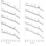
Out of 62 soil samples, representative 10 sample clay fractions obtained by International pipette method were subjected to X-ray diffraction analysis for mineralogical characteristics. Six samples (S.No. S6, S 10, S 11, S 13, and S26) were from irrigated / salt affected zone whereas four (S.No. S29, S49, S56 and S59) were from non-irrigated area (Fig 1). For X ray diffraction analysis samples were powdered to 250 – mesh ASTM sieve. The characteristics of clay samples were recorded on PW172. X – Ray diffractometer using CuKα radiation operated at 30 KV and 30 mA (Cu). The CuKα radiation wavelength was 1.542° A. The scanning speed was maintained at 0.05° 2θ /s and chart speed was 5 mm/2θ starting with 2θ = 10 degrees. For the identification of different peaks, Hanwalt’s method has been used in which peaks are composted with ASTM cards. The typical X-ray diffraction pattern of the clay fractions under investigation is shown in Fig 2.
Results and Discussion
Mineralogical Characteristics of Soils
It is observed from the fig 2 that the important clay minerals identified in the clay fractions of the soil samples under investigation are illite, montmorillonite, kaolinite, chlorite and halloysite.
 |
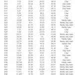
Table 1: Textural Characteristics of the soils from Sangamner area Click here to View table |
 |
Figure 1: Location Map Showing Soil Sampling Stations in the Study Area Click here to View table |
Illite
The dominance of illite in all samples reflected the alkaline nature of the soils along with high concentration of aluminum and potassium. This is further evidenced by the chemical analysis of soils.20 Illite is identified by series of basal reflections at 1.99°A, 3.32° 2.57° A and 2.07° A, besides the weaker reflections at 1.52°A, 4.81° A and 3.1° A. The presence of illite in the samples is indicative of the influence of olivence / enstatitic pyroxene dominated parent material. However, the formation of illite is more favoured due to high K2O content of these soils20. This is possibly due to excessive use of potash fertilizers.
Montmorillonite
The XRD pattern of salt affected soils in the area revealed the formation of montmorillonite (smectites). This can be attributed to alkaline condition and availability of sodium and magnesium. Such hyper alkaline condition can be developed due to impeded drainage in the area.1,21 Montmorillonite presence is seen as 100% reflection at 4.41° A and weaker reflections at 1.53°A to 3.48°A. Similarly, weaker reflections were also identified in the range of 1.29° A to 7.73°A. Under alkaline conditions, the pyroxenes from basalt are believed to weather to clay of this type and fine sand. The smectite type of minerals once formed, remain stable under alkaline conditions that can develop impeded drainage. In the low lying area, it appears that slightly weathered parent materials under alkaline conditions, low Mg and poor drainage condition have accelerated the formation of smectite.22 However, the normal soil showed less proportion of montmorillonite indicating adequate drainage and leaching of magnesium from the host rock basalt.
 |
Figure 2: XRD Diffractogram for Some Clay Fractions of Representative Soil Samples Click here to View table |
 |
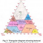
Figure 3: Triangular Diagram Showing Textural Classification of Soils from Study Area Click here to View table |
Kaolinite
It is a major component in almost all the soil samples from study area. It is represented by basal reflection at 7.13 to 7.24° A and 3.55° A. However, in the presence of chlorite as in the case of present samples, the above reflection interfere and coincide with the chlorite at 7.14 and 3.54°A respectively. The other reflections were identified with the lesser intensity at 2.43°A, 2.86, 2.57 and 2.2°A. In the upland soils the dominance of kaolinite might be attributed to the good internal drainage. The plagioclase feldspar has undergone weathering to kaolinite at low pH. However, it is observed that kaolinite reflection does not show any systematic variation in intensity.
Chlorite
It is represented by basal reflections at 7.14°A and weak reflection at 1.55°A. However, because of interference and coincidence of reflections of chlorite with reflection of kaolinite, it was rather difficult to distinguish between the peaks of kaolinite and chlorite in the soil samples under study.
Halloysite
It is the mineral, which belongs to kandite group.21 It is known to occur in two forms with basal spacing 10° A and 7° A as halloysite and methahalloysite respectively. In the present study, 100% intensity has been detected at 4.43° A and 4.52° A, which indicated the presence of hydrated halloysite in all the samples under study.
By and large, it can be inferred that the formation of illite in the area is generally facilitated by the presence of cations like potassium and sodium in sufficiently large quantities. The montmorillonite present in salt affected soils is due to the predominance of magnesium or other alkaline earth cations. Kaolinite, chlorite and halloysite were also detected in the soils samples. However, no remarkable difference was seen in the clay mineral composition in the soils from the area.
Textural Characteristics of Soils from the Sangamner Area
The textural characteristics of the soils are the most important laboratory determinations made in the soil studies. It deals with the process of determining the amount of individual soil separates below 2 mm in diameter i.e. sand, silt and clay. The relative proportions of these soil separates are referred to as soil texture. The various relationships that exist between plant and soil are controlled to a great extent by soil texture.1
It is observed from the table 1, that majority of the soils are in the clay and clay loam category. The clay content varies from 9.51 to 53.61 %. However, the clay and clay loam type of soils were reported predominantly from the downstream part and in the catchment of Ojhar weir (S. No. S1, S2, S3, S4, S5, S8, S9, S10, S12, S14, S15, S16 and S33). This is possibly due to inadequate drainage due to unfavorable topography and siltation at Ojhar weir. In addition to this, presence of alluvial deposits showing low permeability has lead to higher clay content.
The silt content of the soils ranged from 10.8 to 33% However, higher values of slit were noticed for the soils from irrigated tract and in the areas of lower elevation (S. No. S6, S9, S12, S13, S14 and S16).
The fine sand and coarse sand ranged from 6.076 to 59.24% and 3.696 to 33.31% respectively. The higher content of these sands was recorded in the vicinity and downstream part of Ojhar weir (S.No. S21, S23, S24, S29, S39, S43 and S60). However, low values were found in the areas with flat topography (S, No.S5, S10, and S15) and characterized by alluvial lithology. Similar observations were made by the researchers7,14,23,24 for the soils from the area which is in proximity to the present study area. This inference is also supported by cation exchange capacity values.20
The distribution of particle size influences the moisture retention and transmission properties of soils. This is to say that, coarse textured soils have low moisture retention and high permeability whereas fine textured soils have high moisture retention and low permeability.25 Considering this, it can be said that the soils having high clay content (S. No. S2, S3, S4, S5, S7, S8, S9, S10, S16 and S20) will have low infiltration rate. The chemical properties of soils are expected to be influenced by clays than silt and sand particles. This is because clay fraction contains larger alumino – silicates and has higher content of humus. Therefore, they are characterized by a higher charge density per unit surface.26 In the study area, high proportion of clay in some parts of study area can be considered as one of the important factors influencing the chemical properties of soils.20
Textural Classification of the Soil
Natural field soils are always mixtures of soil separates. The relative percentages of the various soil separates in a field are almost infinite in possible combinations. It is, therefore, necessary to establish limits of variations among the soil sepa-rates so as to group them into textural classes. The determination of the textural class of a soil is based on particle size analysis. The soil samples from study area are separated into three size fractions viz. sand, silt and clay. The quantity of each fraction was measured and expressed as a percentage (by weight) of the soil. The distribution of the different sized particles was used for determining textural class of the soil with the help of textural triangular diagram (Fig 3).10,16 On the basis of this, five tex-tural groups were obtained viz clay, clay loam, sandy loam, sandy clay loam and sandy clay from the study area (Fig 3).
Out of 62 soil samples, 22 soil samples (35.48%) were clay, 14 samples (22.58%) were clay loam, 10 samples (16.12%) were sandy loam, 12 samples (20.96%) were sandy clay loam and 3 (4.84%) were sandy clay. Thus, majority of the samples in the area represent clay and clay loam type of textural class. The distribution of various textural classes is depicted in Fig 3.
From the Fig, it is observed that the clay and clay loams were located in the central and downstream part in the back-waters of Ojhar weir. (S.No. S1, S2, S3, S4, S5, S6, S7, S8, S9, S10, S12, S14, S15, S16, S17, S18, S34, S35, S36, S37, S38, S51, S57, S58, S59 and S62). This particular area is waterlogged due to flat topography and impeded drainage. Similar observations were also reported7,23,24 from adjoining areas in the same basin. In nutshell, textural classification of soil provides a basis for making judge-ment about various other properties important to overall soil behavior in the area.
Conclusion
The studies carried out to know mineralogical characteristics of the soils from Sangamner area have demonstrated the importance of clay minerals in relation to soil fertility. The clay minerals identified by the XRD studies of the representative soil samples indicated presence of illite followed by montmorillonite, kaolinite and halloysite in the area. The formation of illite in the soil is generally facilitated by the presence of cations like potassium and sodium in sufficiently large quantities. The montmorillonite present in salt affected soils has the predominance of magnesium. However, no remarkable difference was seen in the clay mineral composition in the soils from the area.
The textural analysis revealed the predominance of clay to clay loam textural type of soils which are located in the downstream part i.e. in the catchment of Ojhar weir. This is possibly attributable to inadequate drainage conditions prevailing in the area. The five textural groups of soils viz. clay, clay loam, sandy loam, sandy clay loam and sandy clay were identified in the area. Out of these, majority of the samples represent clay and clay loam type, which are located in the downstream part of the river. The percentage distribution of these textural classes is clay (35.48%), clay loam (22.58%), sandy clay loam (21%), sandy loam (16%) and sandy clay (5%). The present investigation suggested that adequate drainage and leaching, crop rotation, blending of saline water with good quality of water, use of manures and mulching and desiltation of Ojhar weir can be adapted as measures to improve soil fertility of the area. Farmer’s participation has been looked as the best means of avoiding further degradation of soils in the area.
Acknowledgements
The author is thankful to Dr. N. J. Pawar, Vice-Chancellor, Shivaji University, Kolhapur for his valuable guidance and constant encouragement. The author is also thankful to Head, Department of Environmental Science, University of Pune and Post-Graduate Research Centre in Chemistry, Sangamner College, Sangamner for providing necessary research facilities. The author is also thankful to Head, Department of physics, University of Pune for providing X- ray diffraction analysis.
References
- Miller R.W. and Donahue R.L., Soils : An introduction to soils and plant growth, Prelatic Hall of India, Pvt Ltd, New Delhi (1992).
- Thompson L.M. and Troen F.R., Soils and Soil fertility, 3rd edition McGrawhill Book Co. 137-161 (1973).
- Jain V.K., Biofertilizers for Sustainable Agriculture, Oxford Book company, Jaipur, (2009)
- Colman S.M., Clay mineralogy of rinds and possible implications concerning the sources of clay minerals in soils, Geology, 10: 370 (1982).
- Tewatia R.K. Singh N, Ghabm S.K. and Singh M., J. Ind. Soc. Soil Sci., 37: 687-691 (1989).
- Pancharne T.K., Pal D.K. and Deshpande S.B., J. Ind. Soc. Soil Sci., 44: 300-309 (1996).
- Durgude A.G., Morphology, characterization and mapping of salt affected soils Agricultural University, Rahuri, Ph.D. Thesis, Rahuri (1999).
- Marsonia P.J., Polara J.V. and Hadiyal S.T., Characterization and classification of cultivated soils of Gujarat, An Asian J. of soil Science, 3(2): 287-288 (2008)
- Meena R.B., Balpande S.S., Bahaulkar V.P. and Mandle M.G., Characterization and classification of water logged soils of Upper Wardha area of Maharastra, J. soils and crops, 21(1): 90-94 (2011).
- Gupta P.K., Soil, Water, Plant and Fertilizer analysis, 2nd Edition, Agrobios Publishers, Jodhpur (2009).
- Briggs D. Soils, Butterworths and Co-Publishers, London 129-134 (1977).
- Maji B. and Bandopadhyaya B.K., J. Ind. Soc. Soil Sci., 43(1): 103-107 (1995).
- Hopkins D.G. and Richardson J.L., Hydrology, 7: 380-392 (1999).
- Challa O.B.P., Bhaskar S.G., Anatwar and. Gaikwad M.S, Characterization and classification of problematic vertisols in semi-arid ecosystem of Maharashtra plateau J. Ind. Soc. Soil Sci. 48 (1): 139-145 (2000).
- Grace G. and Eta N.E., Research Journal of Chemistry and Environment, 15(2): 1-4 (2011).
- U.S. Salinity Laboratory Staff, Diagnosis and Improvement of saline and alkali soils, USDA, Handbook No. 60, U.S. Dept of Agriculture, Washington D.C. (1954).
- Hesse P.R., A textbook of soil chemical analysis, John Murry Publication, London, U.K. (1971).
- Piper C.S., Soil and plant analysis, Hans. Publication Bombay (1966).
- Jackson M.L., Soil chemical analysis, Prentice Hall of India, New Delhi (1973).
- Deshmukh K.K. Impact of irrigation on the Chemistry of the soils and groundwater from Sangamner area, Ahmednagar district, Maharashtra, Ph.D. Thesis, University of Pune (2001).
- Deer W.A. Howe R.A. and Zooman J. An introduction to rock minerals, Longman group, London, 250-269 (1980).
- Singh A, Yadhav R.B. Tripathi S.B. and Arya R.L., Fertilizer News, 43(8): 45-50 (1998).
- Shinde M.D., Study on soil characteristics and effect on green algae from Pravaranagar area, Ahmednagar district, Ph.D. Thesis, University of Pune (1997).
- Bharmbe P.R. and Ghonsikar C.P. Physico – Chemicals Characteristics of Soils in Jayakwadi Command, J. Maharashtra Agri. University, 10: 247-249 (1985).
- Richards L.A., Diagnosis and Improvement of saline soils U.S. Salinity Laboratory Staff, Agriculture Handbook No. 60, oxford and IBH Publishing Co. New Delhi (1968).
- Orlov D.S., Soil Chemistry, Oxford and IBH publishers, New Delhi (1992).
- M. Zamani, Orient. J. Chem., 28(1): 491-497 (2012).
- R.V. Kumar, A. Arokiaraj and P.M.D. Prasath, Orient. J. Chem. 27(2): 567-571 (2011).


