Sustainable Landfill Site Selection in Urban Areas: Case Study of Millenium City in India
1
Department of Geography,
Kurukshetra University,
Kurukshetra,
Haryana
India
Corresponding author Email: geog2127sandeep@kuk.ac.in
DOI: http://dx.doi.org/10.12944/CWE.19.3.40
Copy the following to cite this article:
Khanna S, Chauhan S. Sustainable Landfill Site Selection in Urban Areas: Case Study of Millenium City in India. Curr World Environ 2024;19(3). DOI:http://dx.doi.org/10.12944/CWE.19.3.40
Copy the following to cite this URL:
Khanna S, Chauhan S. Sustainable Landfill Site Selection in Urban Areas: Case Study of Millenium City in India. Curr World Environ 2024;19(3).
Download article (pdf)
Citation Manager
Publish History
Select type of program for download
| Endnote EndNote format (Mac & Win) | |
| Reference Manager Ris format (Win only) | |
| Procite Ris format (Win only) | |
| Medlars Format | |
| RefWorks Format RefWorks format (Mac & Win) | |
| BibTex Format BibTex format (Mac & Win) |
Article Publishing History
| Received: | 2024-07-29 |
|---|---|
| Accepted: | 2024-12-16 |
| Reviewed by: | 
 Valentí Turu i Michels
|
| Second Review by: |

 Arunangshu Mukherjee
|
| Final Approval by: | Dr. P. A. Azeez |
Introduction
Effective management of solid waste presents a notable challenge in urban regions, particularly aggravated by the swift migration of rural dwellers seeking better livelihoods and living conditions.1 In India, urbanization has witnessed substantial expansion, with the urban population surging from 11.4% in 1901 to 31.16% in 2011. Projections suggest that by 2050, fifty percent population will be living in urban areas.2 This trend toward urbanization, along with an increase in per capita waste generation, has led to numerous challenges in solid waste management, including issues with collection, disposal, and processing. Despite efforts, more than 40% of the waste collected in India continues to be disposed of in landfills and dumpsites, creating environmental risks and impacting the overall quality of life.3
Therefore, it is crucial to systematically locate appropriate landfill sites that comply with government standards to reduce environmental and health risks. Increasingly, decision-makers have turned to GIS with Multi-Criteria Decision Analysis (MCDA) methods to make informed and sustainable choices about where to place landfill sites.4-6 GIS technology has transformed spatial analysis and decision-making processes.7 It enables the integration and visualization of spatial data, allowing users to generate, manage, analyze, and interpret geographic information.6,7 GIS empowers decision-makers to visualize intricate spatial relationships, facilitating the identification of potential landfill sites and enabling stakeholders to evaluate how different criteria influence site selection.8-10 While GIS provides the spatial context for selecting landfill sites, MCDA techniques act as the decision-making framework, systematically assessing and prioritizing potential sites based on multiple criteria.11,12
In Gurugram, the rapid urbanization and population growth have precipitated a decline in the city's physical environment. Among the myriad challenges faced by local authorities, effective solid waste management stands out prominently. The city center faces significant challenges stemming from considerable waste generation, an inadequate system for collecting and transporting waste, and a shortage of suitable disposal options. These factors have far-reaching consequences for public health, environmental sustainability, and the general welfare of inhabitants. According to records from the Municipal Corporation Gurugram, the city produces approximately 1100 metric tons of solid waste per day.13 The current dumping site, located near Bandhwari village in Gurugram (28°24'89"N 77°10'86"E), has already reached its capacity, being inundated with millions of tons of solid waste. Considering these challenges, the present study endeavors to identify a selection of suitable landfill sites that adhere to the standards outlined by Ministry of Environment, Forest and Climate Change (MoEFCC), India. Initially, an assessment was conducted to gauge the suitability of existing landfill sites based on the prescribed standards. The comprehensive analysis aims to equip the municipal corporation with valuable insights into the establishment of new landfill sites, enabling informed decision-making by weighing the advantages and disadvantages of each potential location.
Materials and Methods
Case Study
Gurugram, located in the state of Haryana, India (Fig.1) has emerged as a significant urban center within the National Capital Region (NCR). Formerly known as Gurgaon, this rapidly growing city has witnessed unparalleled development, transforming from a primarily agrarian landscape to a bustling metropolis over the past few decades. Its elevation is 217 meters above the average sea level and the municipal area is divided into 35 wards and 4 zones. The geographical landscape of Gurugram city encompasses approximately 314 square kilometers and a resident population of more than 18 lakh, exhibiting a diverse terrain that includes urbanized areas, industrial zones, agricultural lands, and natural reserves.13 It is located at 28°45` N latitude and 77° 02` E longitude and is situated strategically 25 kilometers southwest of New Delhi, Gurugram serves as a vital economic hub, attracting multinational corporations, technology firms, and financial institutions.
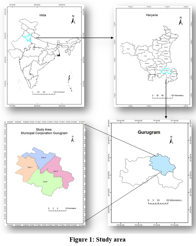 | Figure 1: Study area
|
Methodology
The process of identifying suitable landfill sites necessitates a comprehensive evaluation encompassing various environmental and social factors, including but not limited to land area requirements, soil characteristics, engineering considerations, surface and groundwater conditions, land use patterns, terrain features, wind trajectory, transportation infrastructure (Table. 1).
Table 1: Required data and source for identifying landfill site.
Data Layer | Information Source |
Agricultural Land. Hills (High elevated land and Hills). Transport network (Roads, Railways, and Airports) Urban. Water (River, storage/ponds). Open Land. Barren Land. | SENTINEL-2 Image for Gurugram (ESRI). SRTM (Shuttle Radar Topography Mission) Satellite Data. DEM (30 m) Bhukosh, Geoglogical Survey of India portal. HARSAC, Hisar. Google Earth Engine USGS earth explorer data viz (SRTM VOID filled) |
Landfill Site Identification Criteria
The MoEFCC, India, has established and revised criteria for the identification of landfill sites through the notification of the SWM Rules in 2016.15 In addition to these regulatory standards, numerous environmental and socio-economic factors have been examined in diverse studies focused on landfill site identification. Table 2 provides a summary of the environmental factors utilized in various studies. For our current investigation, we have incorporated several additional factors beyond those stipulated by the SWM rules, 2016.14-16
Table 2: Identification parameters for landfill sites
Sr. No. | Parameter | Standards & References |
1. | Slopes | Not more than 10 percent. |
2. | Water bodies on Surface | 100 m from river flood plain and 200 m from pond and lakes. |
3. | Water supply sources | Minimum 200 m distance. |
4. | Wind direction | The determination of the landfill's location and orientation depends on the direction of the dominant wind. |
5. | Distance form residential areas | 500 m from residential areas. |
6. | Soil texture | Alluvial plains need to be avoided. |
7. | Highways and Railway tracks | 500 m distance. |
8. | Airport & Airbase | 20 km distance. |
9. | Historical and cultural sites | 500 m from the historical and cultural sites. |
10. | Environmental Protected Area | 500 m buffer. |
Accuracy assessment
A method employing stratified random sampling was employed to establish both the sample sizes and their spatial locations.16 Utilizing ArcMap 10, random points were generated to facilitate the accuracy assessment process. Reference data were meticulously collected through visual interpretation of Google Earth and Bhuvan portal.17,18
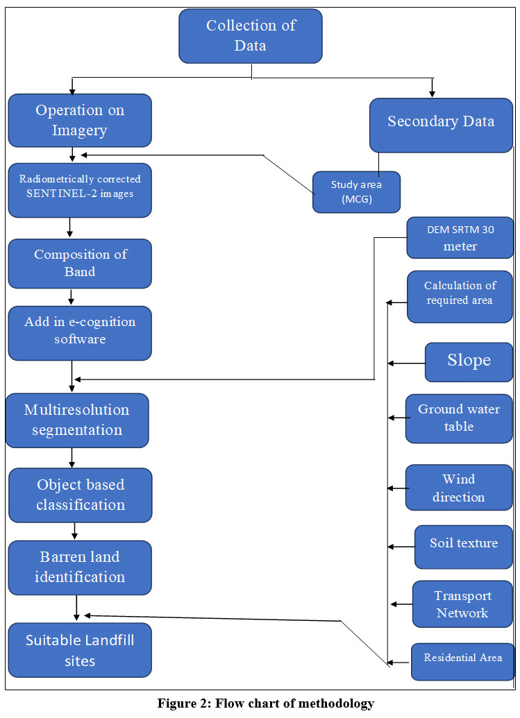 | Figure 2: Flow chart of methodology
|
Identification of Suitable Landfill Site:
The environmental criteria listed in Table 2 were utilized to assess the classified image, identifying potential sites from the barren land class. Sites that did not meet the selection criteria and area specifications were eliminated, and this process was repeated for all environmental criteria until a final group of selected sites was determined. Relevant vector files were created in ArcMap for each selection criterion, or parameters such as distance to class, enclosed by class, relative border to class, or relation to nearby objects were employed.
Results
Solid Waste Generation
Gurugram city’s per person waste generation is projected to be 0.56 kg/day, including residential, business, and institutional waste. It is linked to several factors, including food habits, living standards, and the level of economic and industrial activity in the study area. As already mentioned, approximately 1100 metric tons of municipal waste is generated and controlled (Wet waste: 576 metric tons, Dry waste: 448 metric tons). According to the Indian situation, Gurugram's solid waste will be 50-52 percent biodegradable, 12-15 percent dry recycles, and 30-35 percent inert components.
Required area estimates for landfill site
Given the increasing population and expansion of urban areas, it is recommended to designate a landfill site capable of serving for a minimum of 20 years. The determination of the necessary area is conducted using CPHEEO guidelines, which is 134 hectares.15
LULC Classification
In the process of site identification, the image was classified using the seven bands of SENTINEL-2 data (Fig.1). For image segmentation, a widely recognized supervised multiresolution segmentation technique was employed.18 This method operates on a bottom-up region-based principle, wherein individual pixels initially serve as seed objects. Following this, seed objects endeavor to find the best mutual fit based on a fusion factor value, with a minimum fusion factor threshold in mind. If the fusion factor between any two objects drops below the square of the scale factor, those objects are combined. This merging process persists until further amalgamation becomes unfeasible.
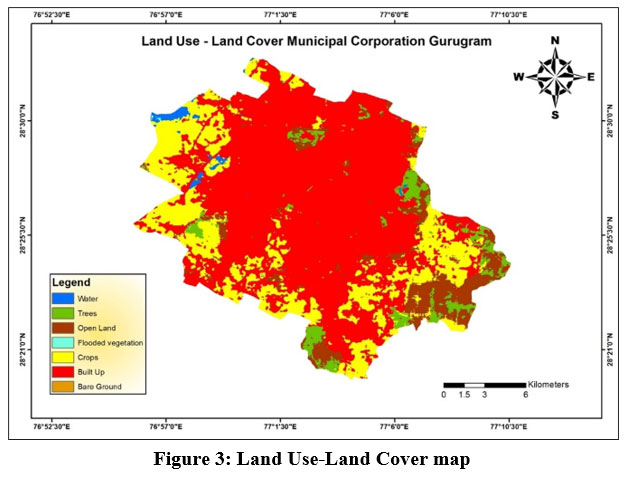 | Figure 3: Land Use-Land Cover map
|
Slope
When considering cost-effectiveness, gently sloping areas are preferred over steep slopes because they require less expenditure on earthwork and excavation. Moreover, areas characterized by steep slopes pose a heightened risk of stability slope. Consequently, in this study, regions falling within the higher slope class (>10%) were excluded from further consideration (Fig.4).
Soils
In the designated study area, three predominant soil types are typically recognized: Loam, Clay Loam, and Sandy Clay Loam. Conversely, silt and fine silty clay are regarded as the most suitable textures for landfill sites. However, because grain-size is directly related to permeability, loam and loamy sand soils generally demonstrate lower permeability compared to sandy soils, according to information provided by the Food and Agriculture Organization (FAO). For this investigation, preference was given to sites characterized by loam and sandy clay loam soils exclusively (Fig.5).
Waterbodies and natural stream network
As part of the site selection process, stringent criteria were applied, leading to the exclusion of any potential sites falling within specific buffer zones: 500 meters from surface-flowing water, 100 meters from flood plains, or 200 meters from ponds, lakes, and other water bodies (Fig.6). These criteria served to ensure the selection of suitable sites while mitigating potential environmental risks.
Groundwater levels
According to guidelines outlined by CPHEEO, 2016, the base level of the landfill should maintain a minimum elevation of 2 meters above the highest recorded water table.15 Given the intended landfill depth of 10-20 meters, it is advisable to avoid selecting sites where the water table lies within the range of 9-25 meters from the land surface. Figure 7 displays data on groundwater levels gathered from various monitoring stations across the study area, offering insights into the hydrogeological conditions pertinent to site selection considerations.
Dominant wind trajectory
To discern the typical monthly wind patterns, information sourced from the global wind atlas was employed to compute 24-hour back trajectories at a height of 10 meters above ground level, specifically at 10:00 AM Indian Standard Time (IST). Figure 8 illustrates the prevailing wind directions within the study area, depicting wind frequency, wind power, and wind speed distribution through a wind rose diagram.
Transportation network
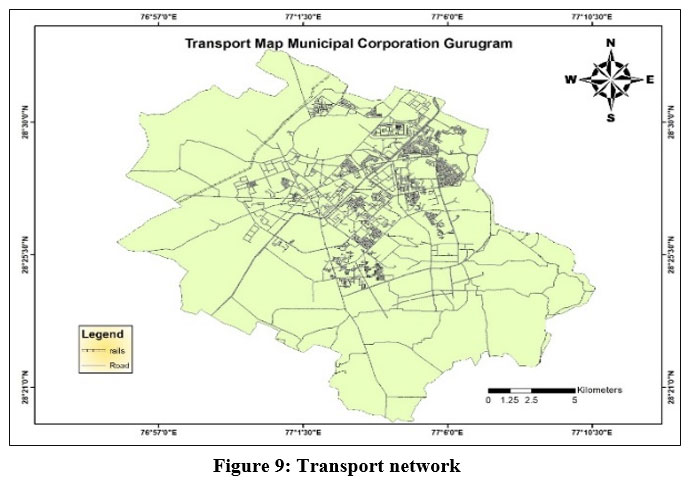
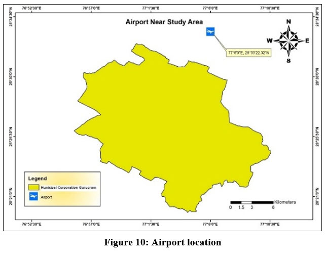
In the selection process, it is imperative that chosen sites maintain a buffer zone of 0.5 kilometers from highways and 20 kilometers from airport runways to mitigate potential risks. Landfill sites have the propensity to attract birds, posing a risk of accidents to cars in roads and airplanes in airports. For this study, sites were identified based on the criterion of maintaining a minimum distance of 20 km from Indira Gandhi International Airport in New Delhi (Fig.9).
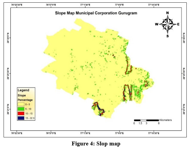 | Figure 4: Slop map
|
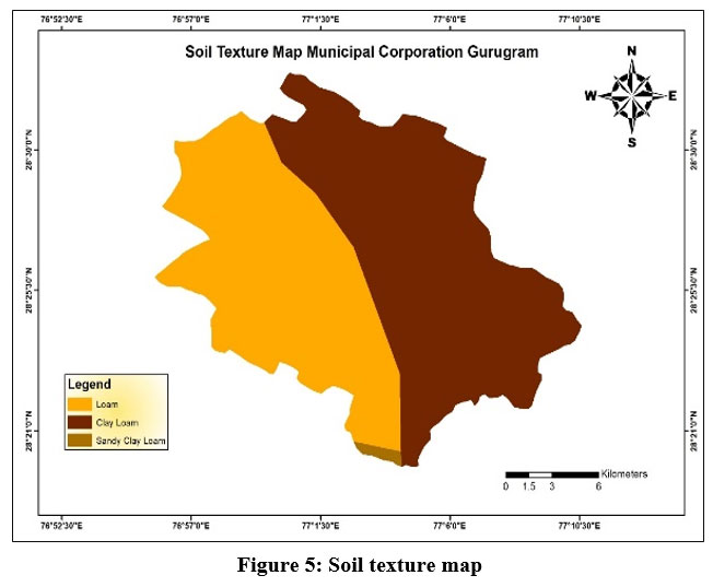 | Figure 5: Soil texture map.
|
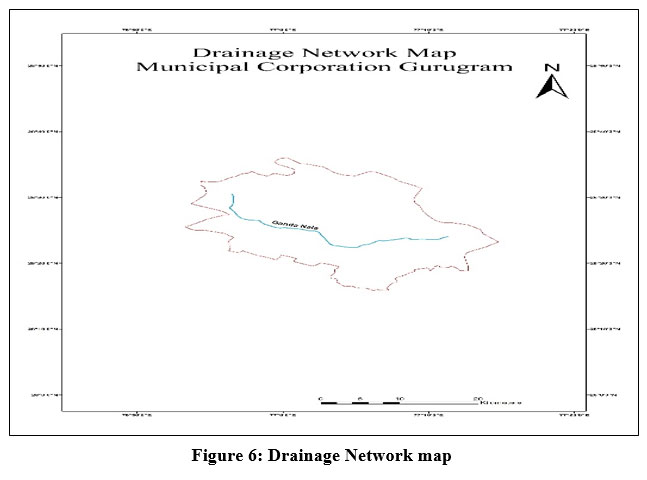 | Figure 6: Drainage Network map
|
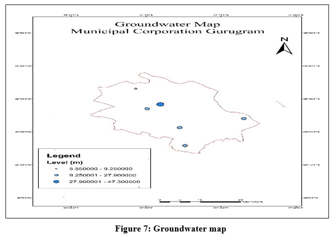 | Figure 7: Groundwater map
|
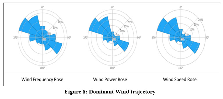 | Figure 8: Dominant Wind trajectory
|
 | Figure 9: Transport network
|
 | Figure 10: Airport location
|
Ponderation
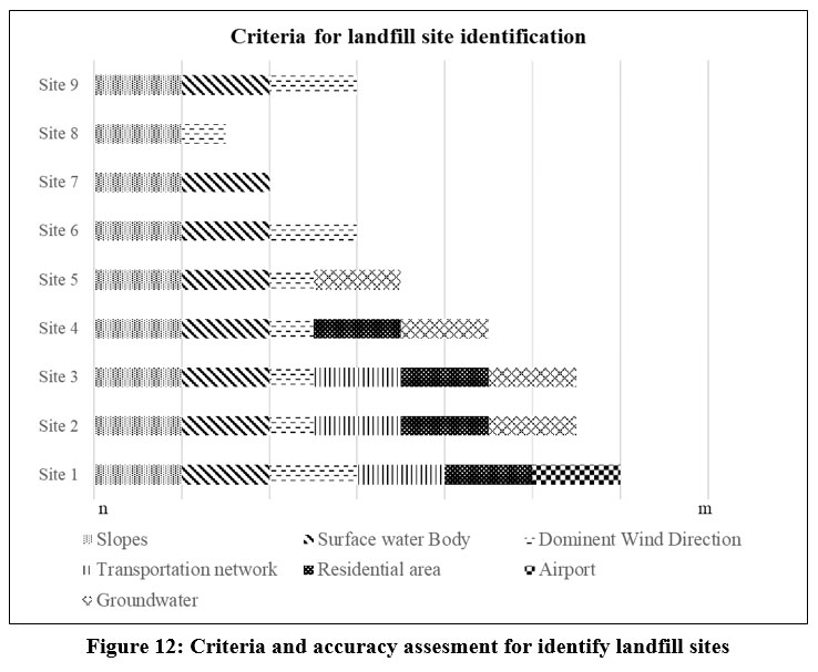
Once all data was processed as explained in the methodology section, the assessment of potential sites are shown in figure 10, going for a minimum value of `n` until a maximum value of `m`, being the highest value the best suitable waste landfill location.
Discussion
Comprehensive explanation for landfill site identification
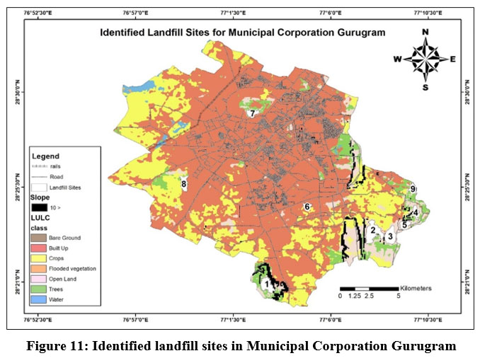
Site 1: Positioned in the southwestern sector of the city, this site neighbors the Bhondsi and Nayagaon settlements to the east (Fig. 13). However, it falls short in meeting groundwater criteria, as depicted in Figure 12. Residents residing nearby may encounter challenges due to the presence of the landfill, potentially leading to water contamination. Failure to adhere to the guidelines outlined in the Solid Waste Management (SWM) Rules of 2016 could pose risks to public health and the environment.15
Site 2: Located to the west of Behrampur and southeast of Gurugram city (Fig. 13), this site emerges as a prime contender for a landfill, meeting nearly all specified criteria.
Site 3: Situated north of Bandhwari village (Fig.13) and in proximity to the existing landfill site, this location fails to meet airport criteria (Fig. 12).
Sites 4 and 5: Found southeast of Balota and southeast of the city (Fig. 13), both sites meet slope, surface water, and groundwater criteria but are unsuitable due to non-compliance with airport, highway, and railway criteria (Fig. 12).
Site 6: Close to settlement areas like Sushant Lok Phase 3 and Sector 57 (Fig. 13), this site is unsuitable for landfill due to non-compliance with highway, railway, airport, and residential criteria (Fig. 12).
Site 7: Located in south of Cartarpuri village (Fig. 13), this site is unsuitable for landfill due to factors such as wind direction, transportation network, residential presence, and groundwater considerations.
Site 8: Positioned west of Khandsa and Narsinghpur village, this site meets only slope and wind direction criteria, falling short on the remaining five criteria (Fig. 12).
Site 9: Situated southeast of the city near New Gwal Pahari village, this site fails to meet criteria related to transportation, airport proximity, residential presence, and groundwater suitability.
 | Figure 11: Identified landfill sites in Municipal Corporation Gurugram
|
 | Figure 12: Criteria and accuracy assesment for identify landfill sites
|
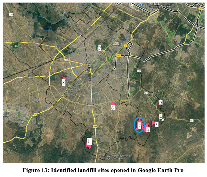 | Figure 13: Identified landfill sites opened in Google Earth Pro
|
Conclusion
This study presents a comprehensive framework for landfill site selection, emphasizing the integration of scientific analysis and regulatory compliance to promote sustainable waste management practices. Among the nine evaluated sites, Site 2 emerged as the most suitable option for landfill storage, albeit with some reservations (Fig. 12). The assessment highlights the challenges of balancing immediate waste disposal needs with long-term sustainability goals, especially in the context of rapid urbanization and population growth.
The findings underscore the necessity for municipal authorities and urban planners to adopt data-driven, environmentally responsible strategies for waste management. By addressing critical criteria such as groundwater protection, residential proximity, and adherence to the Solid Waste Management Rules of 2016,15 this framework provides a roadmap for minimizing environmental and public health risks. Looking ahead, advancing research and innovation in waste management will be pivotal to adapting to the complexities of urban development. This study contributes valuable insights to support decision-makers in navigating these challenges, offering a robust foundation for sustainable urban planning. Ultimately, the proposed approach not only meets current waste disposal demands but also ensures the well-being of communities and ecosystems, fostering a more resilient and environmentally conscious future.
Acknowledgement
The author would like to thank Municipal Corporation Gurugram, Haryana for providing the related data. Swachh Bharat Mission (SBM) Gurugram wing is highly appreciated for its consultancy.
Funding Sources
This study was supported by the Ministry of Social Justice & Empowerment, Government of India, under the National Fellowship for Scheduled Caste Students (Reference No. 200510006280). The authors are grateful for the financial assistance provided.
Conflict of Interest
The author(s) do not have any conflict of interest.
Data Availability Statement
This statement does not apply to this article.
Ethics statement
This research did not involve human participants, animal subjects, or any material that requires ethical approval.
Informed Consent Statement
This study did not involve human participants, and therefore, informed consent was not required.”
Author Contributions
Sandeep Khanna and Suman Chauhan conceived the presented idea. Sandeep Khanna developed the theory and performed the computations. Suman Chauhan verified the analytical methods. Suman Chauhan encouraged Sandeep Khanna to investigate status of current landfill site and supervised the findings of this work. All authors discussed the results and contributed to the final manuscript.
References
- Hui, Y. Urban solid waste management in Chongqing: Challenges and opportunities’, Waste Management, 2016;26(9), pp. 1052–1062. doi:10.1016/j.wasman.2005.09.005.
CrossRef - Demography and Development: Preliminary interpretations of the 2011 Census on JSTOR. www.jstor.org. https://www.jstor.org/stable/41152096.
- Joshi R, Ahmed S. Status and challenges of municipal solid waste management in India: A review. Cogent environmental science. 2016;2(1):1139434. doi:10.1080/ 23311843.2016.1139434
CrossRef - Al-Anbari M, Thameer M, Al-Ansari N. Landfill site selection by weighted overlay technique: case study of Al-Kufa, Iraq. Sustainability. 2018;10(4):999. doi:10.3390/su10040999
CrossRef - Lokhande TI, Mane SJ, Mali ST. Landfill site selection using GIS and MCDA methods: a review. Int. J. Res. Eng. Sci. Technol. 2017;3:25-30.
- Aksoy E, San BT. Geographical information systems (GIS) and multi-criteria decision analysis (MCDA) integration for sustainable landfill site selection considering dynamic data source. Bulletin of Engineering Geology and the Environment. 2019;78:779-91. doi:10.1007/s10064-017-1135-z
CrossRef - Alam P, Khan AH, Islam R, Sabi E, Khan NA, Zargar TI. Identification of prevalent leachate percolation of municipal solid waste landfill: a case study in India. Scientific Reports. 2024 Apr 17;14(1):8910. doi:10.1038/s41598-024-58693-5
CrossRef - Choudhary S, Kaur H, Chandra T, Jaiswal S, Anand A. Solid Waste Disposal in Jodhpur, India, Using GIS and MCDA. Sustainable Development and Geospatial Technology: Volume 2: Applications and Future Directions. 2024;2:197. doi: 10.1007/978-3-031-65703-0_13
CrossRef - Pasalari H, Nodehi RN, Mahvi AH, Yaghmaeian K, Charrahi Z. Landfill site selection using a hybrid system of AHP-Fuzzy in GIS environment: A case study in Shiraz city, Iran. MethodsX. 2019;6:1454-1466. doi:10.1016/j.mex.2019.06.009
CrossRef - Zarin R, Azmat M, Naqvi SR, Saddique Q, Ullah S. Landfill site selection by integrating fuzzy logic, AHP, and WLC method based on multi-criteria decision analysis. Environmental Science and Pollution Research. 2021;28(16):19726-19741. doi:10.1007/s11356-020-11975-7
CrossRef - Demesouka OE, Anagnostopoulos KP, Siskos E. Spatial multicriteria decision support for robust land-use suitability: The case of landfill site selection in Northeastern Greece. European Journal of Operational Research. 2019;272(2):574-586. doi:10.1016/j.ejor.2018.07.005
CrossRef - Ali SA, Ahmad A. Suitability analysis for municipal landfill site selection using fuzzy analytic hierarchy process and geospatial technique. Environmental Earth Sciences. 2020;79(10). doi:10.1007/s12665-020-08970-z
CrossRef - Chauhan S. Decsion-making of sustainable municipal solid waste management based on SWOT analysis: a case study of Gurugram City, Haryana (India). Advances in Environmental Research. 2023;12(1):41-49. doi:10.12989/aer.2023.12.1.041
- CPCB | Central Pollution Control Board. CPCB. https://cpcb.nic.in/rules-2/.
- Municipal Solid Waste Management: A step wise guidance. https://cpheeo.gov.in//cms/manual-on-municipal-solid-waste-management-2016.php. Published 2017. Accessed April 7, 2024.
- Demesouka OE, Vavatsikos AP, Anagnostopoulos KP. Suitability analysis for siting MSW landfills and its multicriteria spatial decision support system: Method, implementation and case study. Waste Management. 2013;33(5):1190-1206. doi:10.1016/j.wasman.2013.01.030
CrossRef - Stehman SV. Sampling designs for accuracy assessment of land cover. International Journal of Remote Sensing. 2009;30(20):5243-5272. doi:10.1080/01431160903131000
CrossRef - Gurjar SK, Tare V. Estimating long-term LULC changes in an agriculture-dominated basin using CORONA (1970) and LISS IV (2013–14) satellite images: a case study of Ramganga River, India. Environmental Monitoring and Assessment. 2019;191(4). doi:10.1007/s10661-019-7356-9
CrossRef


