Modeling Spatial Pattern of Salinity Using MIKE21 and Principal Component Analysis Technique in Urmia Lake
Salman Safavi1 , Abolfazl Shamsai1 * , Bahram Saghafian1 and Sayed Mohyeddin Bateni2
1
Department of Civil and Environmental Engineering,
Manoa,
University of Hawaii,
Honolulu,
USA
Corresponding author Email: salman.safavi84@gmail.com
DOI: http://dx.doi.org/10.12944/CWE.10.2.28
Urmia Lake in the northwestern of Iran is a hypersaline water body and has become an environmentally important issue especially due to the presence of an infrequent aquatic species, Artemia Urmiana. During the last three decades, several considerable man-made changes including river damming and construction of a causeway across the lake affected the lake salinity. This article aims to propose a new approach of salinity modeling using a reduced-order model based on MIKE21 simulation model, in conjunction with principal component analysis (PCA) technique. At first, spatial variation of salinity in the lake was simulated by MIKE21 to prepare the input information for the PCA. Then, the dominant modes of salinity were determined by PCA technique while MIKE21 simulated results were compared with the output of developed reduced order model. Findings indicated that MIKE21's results closely matched the experimental data collected by field study. Also, the first 10 PCs among 974 modes computed by the reduced order model conserved approximately over 93% of the system variance. Therefore, the reduced order model was sufficient to capture the variation of salinity in the lake using a few first PCs. In other words, it was generally found that improvements in the simulated salinity in the lake provided by reduced order model were comparable to MIKE21 simulations.
Copy the following to cite this article:
Safavi S, Shamsai A, Saghafian B, Bateni S. M. Modeling Spatial Pattern of Salinity Using MIKE21 and Principal Component Analysis Technique in Urmia Lake. Curr World Environ 2015;10(2) DOI:http://dx.doi.org/10.12944/CWE.10.2.28
Copy the following to cite this URL:
Safavi S, Shamsai A, Saghafian B, Bateni S. M. Modeling Spatial Pattern of Salinity Using MIKE21 and Principal Component Analysis Technique in Urmia Lake. Curr World Environ 2015;10(2). Available from: http://www.cwejournal.org/?p=11871
Download article (pdf) Citation Manager Publish History
Select type of program for download
| Endnote EndNote format (Mac & Win) | |
| Reference Manager Ris format (Win only) | |
| Procite Ris format (Win only) | |
| Medlars Format | |
| RefWorks Format RefWorks format (Mac & Win) | |
| BibTex Format BibTex format (Mac & Win) |
Article Publishing History
| Received: | 2015-05-08 |
|---|---|
| Accepted: | 2015-07-10 |
Introduction
Urmia Lake is an internationally registered protected area in Ramsar contention by UNESCO as biosphere reserve in 1971 and 1976. Urmia Lake hosts about 212 different types of bird species and is the only habitat of Artemia Urmiana. In recent years, human activities such as river damming, excessive water withdrawals and construction of Shahid Kalantary causeway in the middle of the lake have adversely affected the natural regime and water salinity of the lake. Recent prolonged droughts have also contributed to decreasing the discharge of inflow Rivers to the lake and consequently have caused dramatic loss in lake’s volume and surface area that has led to increased hyper salinity. Excessive salinity has created a challenging environment for the aquatic organisms living in the lake. In order to search for reclamation measures, spatial patterns of salinity should be studied. Results of such studies may contribute to better understanding of the Urmia lake salinity regime and make an efficient tool for decision makers.
Chubarenko and Tchepikova (2001) simulated Spatio-temporal pattern of salinity by MIKE21 numerical model under different hydrological conditions. Umgiesser and Zampato (2001) simulated currents and salinity field in Venice Lagoon using SHYFEM model. Results indicated an appropriate agreement between simulated salinity and observations. Vialard et al. (2002) studied the salinity variation and reported that the model is capable to simulate the sea surface salinity appropriately. Omstedt and Axell (2003) simulated the salinity and sea surface temperature variation in three gulfs and reported satisfying results. Balistrieri et al. (2006) predicted seasonal changes in salinity using a one-dimensional Dynamic Reservoir Simulation Model (DYRESM) in Dexter Pit Lake. Results indicated that a suitable agreement between salinity simulation and field observations. Wu et al. (2014) simulated the distribution of salinity in an artificial lake via an environmental fluid dynamic code (known as EFDC).
Although salinity simulation in water resources systems, such as lakes, provides important knowledge on spatial changes, however, increasing the number of computational grids is a challenging issue for salinity simulation. Therefore, development of a reduced order framework that incorporates the changes in the main system is desirable. In this regard, coupled two dimensional (2D) model (MIKE21) hydrodynamic simulation model and principal component analysis (PCA) model was proposed in this research. The methodology is developed and evaluated in simulation of salinity in Urmia Lake. At first, 2D simulation of Urmia Lake was performed. Then a reduced order model is developed by linking the MIKE21 simulation model with the PCA model to represent the flow and salinity changes.
Case Study and Data
Urmia Lake is a salty water body in northwest of Iran between 37° N to 38°20′ N and 44°55′E to 45°55′ E. Urmia lake is the largest lake in Iran and the second hyper saline in the world (Ahmadzadeh Kokya et al., 2011).The lake surface area at normal condition is estimated at about 5200km2, a 140 km long by 55 km wide area. Maximum depth at normal condition is approximately 16m (Fazeli et al., 2005). The lake receives water from 13 rivers, the largest of which join the lake from the south. Urmia Lake vicinity is home to some 212 species of birds, 41 reptiles, 7 amphibians, and 27 species of mammals including the Iranian yellow deer. It is an internationally registered protected area by UNESCO Biosphere Reserve and Ramsar site (Fazeli et al., 2005). In the past decades to make a road across from the lake and facilitate the transportation between western and eastern provinces, a causeway constructed between the left and right sides of the lake (Zeinoddini et al., 2009). This causeway adversely affected the flow and salinity regime and prevented the appropriate mixing of saline and fresh water in the lake (Zeinoddini et al., 2013). Recent researches showed higher salinity in the north of the lake (about 60% higher) (Zeinoddini et al., 2009). Also in the past decade, prolonged droughts adversely affected the inflow to the lake. The lake experiences a high salinity between 225 g/l to 280 g/l during drought periods which leads to water level decline (Eimanifar and Mohebbi, 2007). Major changes in the lake salinity impose negative impacts on the Artemia Urmiana and subsequently reduce the diversity of the aquatic life in the lake. As a result, monitoring and simulation of salt concentration is of high priority to preserve ecological conditions of the lake.
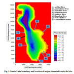
In this research, models’ hydrodynamic forcing were meteorological variables, such as wind speed and direction, atmospheric pressure, mean water-level fluctuations, precipitation, moisture, evaporation, inflows by seven major rivers (Fig. 1) and salinity. The bathymetric information was based on the results of field surveys as described by Sadra Company (2004).
 |
|
Methodology
MIKE21 Model Descriptions
Hydrodynamic governing equations in MIKE21 are mass conservation and momentum equations expressed as follows:
Continuity Equation

Momentum Equation in x Direction

Momentum Equation in y Direction

x, y and tyy, txy, txx are water depth, water level (m), unit discharge (m3/s/m), Chezy coefficient,
gravitational acceleration (m/s2), wind friction coefficient, wind velocity and its components in x and y directions, coriolis parameters, atmospheric pressure (kg/m/s2), water density (kg/m3), location coordinates and effective shear stress components, respectively. MIKE21 uses finite difference numerical method to solve the governing equations. For solving the equations altering direction implicit (ADI) technique is used and Von-Neumann method ia applied to control the stability.
MIKE21 simulates dispersion of soluble materials in water via the following equations

where, C, U, V, h, Dx, Dy, F, Qs, Cs are concentration, velocity components, water depth, dispersion coefficients, linear reduction factor, sink and source discharge and sink and source concentration, respectively. Implicit QUICKEST with third order error is a numerical technique to solve dispersion and transport equations.
PCA Description
Principal Component Analysis (PCA) is the most commonly used dimension reduction technique which describes the variation in a set of multivariate data in terms of a set of uncorrelated variables. PCA is useful for finding new, more informative and uncorrelated features. It reduces dimensionality by rejecting low variance features. The new variables (PCs) have a variance equal to their corresponding eigenvalue. Suppose a data matrix of n observations on p correlated variables x1,x2,…xp. PCA looks for a transformation of the xi into p new variables yi that are uncorrelated.
yi= δT X=δ1 X1+ δ2 X2+..+ δp X .............(5)
Where δ=(δ1 , δ2 ,.., δp)T is a column vector of wheights with
δ1²+ δ2²+..+ δp² =1 .............(6)
Results and Discussions
MKE21’s salinity simulation results
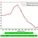
The lake was divided to 400m×400m pixels (24241 pixels). And a full one year period of Jan 2002 to Dec 2002 was considered simulating with MIKE21. The hydrodynamic model of the lake was set up and calibrated with water surface level records in Golmankhaneh station using wind direction and velocity measurements at Urmia synoptic station at different times. The model was executed to find the optimum water level (Fig. 2). Mean absolute error (MSE) corresponding to Fig. 2 was 0.034. This indicates a generally suitable agreement between field measurements and model output. Salinity density obtained by MIKE21 model for 12 months saved in 9-hour time intervals were taken as snapshots. Some 974 snapshots were extracted.
 |
|
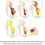
Salinity simulations were performed in computational grids for one year period. Fig. 3 (a) to 3 (d), show spatial distribution of salinity variations in the lake for the middle of spring, summer, autumn and winter seasons, respectively. Also, Fig. 3(e) shows average salinity over one year simulation period. The results indicate that salinity varies in space dimension. Overall, salinity is higher in north than south. This is partly due to the salt inflow from the northern brackish rivers (Zeinoddini et al., 2013). Besides, in the spring due to snowmelt and precipitation, salinity is less than other seasons. By the beginning of summer and increase in evaporation rate, salinity of the lake rises, which this increasing rate continues to the end of winter.
 |
|
Reduced Order Model Results
For reduced order modeling based on PCA, it is necessary to establish PCA functions using MIKE21 salinity output. For this purpose, some snapshots in specific time intervals were taken from MIKE21 results over the simulation period. By applying PCA on the snapshots, PCA functions are generated. The numbers of PCA functions used for further analysis are usually fewer than the number of computational grids so that the judgment on salinity variation based on the selected PCA functions is simplified. PCA function selection depends on what part of information variance is conserved by the functions.
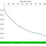
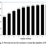
Some 974 snapshots were extracted and arranged by a developed program. In the next step, correlation symmetrical matrix was established using snapshots. Eigen values of the correlation matrix are presented in Fig. 4 in logarithmic scale. Among 974 calculated eigen values, except for the first 10 eigen values that are over unity, others are negligible. So other eigen values do not have a strong effect on the governing physical condition (i.e. lake salinity). For explore this fact, the saved variance percent and the number of modes were drawn for the first ten PCs in Fig. 5. As a result, the first PC conserved 55% of variance while for the all ten PCs, it reached just under 93%. Results of reduced order modeling showed that the first three PCs conserved 55, 10 and 8 percent of variance, respectively; for a cumulative 73 percent.
 |
|
 |
|
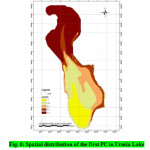
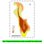
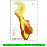
Spatial distribution of the first PC in the lake is drawn in Fig. 6. According to MIKE21’s results, salinity in north is higher than in south and central parts (Fig. 3) that is consistent with the results of the first PC (Fig. 6). Spatial pattern of salinity in the first PC does not fully agree with that of the MIKE21 simulated pattern. Since the first PC conserves 55% of variance in the system, it is not expected that physics of the system be represented just by the first mode; minor differences are expected as a result. Moreover, spatial distributions of the second and third PC in Urmia Lake are presented in Figs. 7 and 8, respectively. Comparison of these two figures with MIKE21’s outputs reveals that a close match does not exist. That is because the 2nd and 3rd PCs conserve a limited variance proportion in the system. Thus, the first PC which conserves a large amount of variance in the system is much more important in salinity simulation of Urmia Lake.
 |
|
 |
|
 |
|
It is notable that the numbers in legends of figure 6 to figure 8 do not show the salinity value. The absolute values show the spatial variation of salinity in the lake.
Conclusions
In this research, a new methodology was developed for simulation of salinity in Urmia Lake, northwestern of Iran. For this purpose, MIKE21 simulation model and the PCA technique were used jointly. First, salinity was simulated by MIKE21. Then due to huge volume of information embedded in MIKE21 in spatial simulation, PCA model was adopted for reduced order modeling. The following conclusions were drawn in this study:
- The most effective parameter in lake water level calibration was wind friction coefficient.
- Salinity is higher in the north than in south of the lake based on MIKE21 simulations.
- Reduced order model results indicated that only the first PC is significant and the effect of others is negligible. The first PC conserved 55% of variance in the system while the first 10 modes conserved 93% of the variance.
- MIKE-PCA conjunctive model had satisfying performance compared to the 974 snapshots obtained from MIKE21.
References
- Ahmadzadeh Kokya, T., Pejman, A.H., Mahin Abdollahzadeh, E., Ahmadzadeh Kokya, B., Nazariha, M. (2011). Evaluation of salt effects on some thermodynamic properties of Urmia Lake water, 5 (2), 343-348.
- Balistrieri, L.S., Tempel, R.N., Stillings, L.L. and Shevenell, L.A. (2006). Modeling spatial and temporal variations in temperature and salinity during stratification and overturn in Dexter Pit Lake, Tuscarora, Nevada, USA. Applied Geochemistry, 21(7), 1184-1203.
- Chubarenko, I., Tchepikova, I. (2001). Modelling of man-made contribution to salinity increase into the Vistula Lagoon (Baltic Sea). Ecological Modeling 138(1-3), 87-100.
- Dehghani, M., Saghafian, B., Nasiri-Saleh, F., Farokhnia, A., Noori, R. (2014). Uncertainty analysis of streamflow drought forecast using artificial neural networks and Monte-Carlo simulation. International Journal of Climatology, 34: 1169–1180.
- Eimanifar, A., Mohebbi, F. (2007). Urmia lake (Northwest Iran): a brief review. Journal saline systems 1-83/1/5.
- Fazeli, M. R., Towghi, H., Samadi, N., Jamalifar, H. (2005). Effects of salinity on carotene production by Dunaliella tertioleca DCCBC26 isolated from the Urmia salt lake, north of Iran. Bioresource Technology, 97, 2453-2456.
- Manly B.F.J. (1986). Multivariate Statistical Methods: A Primer. 2nd Edition, Chapman & Hall, London.
- Noori, R., Karbassi, A.R., Moghaddamnia A., Han D., Zokaei-Ashtiani, M.H., Farokhnia, A., Ghafari Gousheh M. (2011). Assessment of input variables determination on the SVM model performance using PCA, Gamma test, and forward selection techniques for monthly stream flow prediction. Journal of hydrology, 401:177-189.
- Omstedt, A., Axell, L.B. (2003). Modeling the variations of salinity and temperature in the large Gulfs of the Baltic Sea. Continental Shelf Research 23(3-4), 265-294.
- Sadra Company (2004). Hydrodynamic, hydraulic and environmental investigation report (design and construction of the Urmia Lake causeway), rev. 4, Tehran.
- Tabachnick B.G., Fidell L.S. (2001). Using Multivariate Statistics, 3rd edition. Allyn and Bacon, Boston, London.
- Umgiesser, G., Zampato, L. (2001). Hydrodynamic and salinity modeling of the Venice channel network with coupled 1-D-2-D mathematical models. Ecological Modeling 138(1-3), 75-85.
- Vialard, J., Delecluse, P., Menkes, C. (2002). A modeling study of salinity variability and its effects in the tropical Pacific Ocean during the 1993-1999 period. Journal of Geophysical Research Oceans 107(C12), 6-14.
- Wackernagel, H., (1995). Multivariate Geostatistics: An Introduction with Applications. 2nd edition, Springer, New York and London.
- Wu, C.B., Deng, X.W., Yuan, X.Z., Chen, H., Zhang, L.Y., Jiao, Y.J. (2014). Simulation of salinity in artificial lake in coastal region. Applied Mechanics and Materials 444-445, 1127-1131.
- Zeinoddini, M.,Tofighi, M.A., Vafaee, F. (2009). Evaluation of dike-type causeway impacts on the flow and salinity regimes in Urmia Lake, Iran. Journal of Great Lakes Research 35(1), 13-22.
- Zeinoddini, M., Bakhtiari, A., Ehteshami, M. (2013). Wave-flow coupling effects on spatiotemporal variations of flow and salinity in a large hypersaline marine system, Urmia Lake, Iran. Limnology, 14, 77-95.


