Analyzing Urban Sprawl and Land Use Transformation in Palakkad Municipality, Kerala, India
Nazrin Begum Sardar1
 , Ameen Abdul Salam2
*
and Roobina Aboobakker1
, Ameen Abdul Salam2
*
and Roobina Aboobakker1
1
Department of Geography,
Government College Chittur,
Palakkad,
Kerala
India
2
Department of Geology and Digital Surveying,
Fatima Mata National College (Autonomous),
Kollam,
Kerala
India
http://dx.doi.org/10.12944/CWE.21.1.25
Copy the following to cite this article:
Sardar N. B, Salam A. A, Aboobakker R. Analyzing Urban Sprawl and Land Use Transformation in Palakkad Municipality, Kerala, India. Curr World Environ 2026;21(1). DOI:http://dx.doi.org/10.12944/CWE.21.1.25
Copy the following to cite this URL:
Sardar N. B, Salam A. A, Aboobakker R. Analyzing Urban Sprawl and Land Use Transformation in Palakkad Municipality, Kerala, India. Curr World Environ 2026;21(1).
Download article (pdf)
Citation Manager
Publish History

Introduction
Urban sprawl is commonly understood as a pattern of dispersed and poorly coordinated urban growth that extends beyond established city boundaries into previously non-urban areas.1 As populations grow and cities modernise, development typically spills over city limits, resulting in low-density, scattered settlements.2This horizontal expansion continually strains existing public infrastructure, increases commuting distances and transportation costs, and irreversibly replaces fertile farmland and natural habitats with impervious concrete surfaces.3 The environmental consequences of such transformations are severe. They reduce regional biodiversity, increase soil erosion, and drastically disrupt natural hydrological processes by limiting groundwater recharge and altering surface runoff. Furthermore, the rapid depletion of agricultural land directly threatens local food security and complicates natural resource management, creating a pressing challenge for rapidly developing municipalities that must balance economic growth with ecological preservation.4,5However, the characteristics of urban sprawl vary significantly across different spatial contexts. While classical definitions often reflect low-density suburban expansion typical of Western cities, urban growth in Indian medium-sized towns tends to exhibit mixed-density and corridor-based expansion influenced by transportation networks and institutional development.
Addressing the complexities associated with urban sprawl necessitates the use of geospatial tools, including remote sensing and Geographic Information Systems (GIS), to effectively monitor and analyse land surface changes over time.6,7 Traditional land surveying methods, while highly accurate at a micro-level, are labour-intensive, time-consuming, and cost-prohibitive for large-scale, continuous monitoring.8,9 In contrast, remote sensing offers a cost-effective, comprehensive view of vast geographic areas, enabling researchers to track spatiotemporal urban growth patterns through repeated, multi-spectral satellite observations.10 GIS functions as the analytical core, providing advanced tools to process spatial data, classify land cover types, and evaluate structural changes across different time periods.11 Together, these integrated geoinformatics tools enhance the understanding of how urbanisation physically transforms land cover, helping city planners to map historical growth trajectories, predict future expansion zones, and develop effective policies to control urban sprawl.
The continuous monitoring of temporal changes in the land using these spatial analysis tools is essential for evidence-based urban planning. As cities expand, the widespread global trend of converting natural landscapes and vital agricultural zones into built-up areas increasingly threatens delicate ecosystems and overall urban livability.12 Geoinformatics provides timely and highly accurate LULC data, which is crucial for preventing socio-ecological harm and guiding municipalities toward sustainable development.13 By accurately mapping both current urban growth patterns and the historical footprint of built-up areas, decision-makers can better understand the underlying drivers of urbanisation.14This spatial intelligence is vital for implementing zoning regulations, protecting vulnerable farmlands, conserving green spaces, and maintaining critical ecosystem services amid rapid modernisation.
In the regional context, Palakkad, widely recognised as the "Gateway of Kerala", offers a compelling example of rapid urban transformation. Located near the Palghat Gap in the Western Ghats, the city has historically served as a vital commercial and cultural corridor connecting Kerala to the rest of India. In recent decades, Palakkad has experienced significant urbanisation driven by shifting demographic patterns, increased economic activities, and major infrastructure developments.15This unregulated expansion has gradually shifted from a centralised core to extensive horizontal growth, leading to the ongoing depletion of traditional agricultural lands, mixed tree vegetation, and local ecosystems.16 Therefore, an integrated analysis using GIS and remote sensing is crucial to understanding these region-specific land transformations, assessing their environmental impacts, and creating a data-driven basis for sustainable urban planning.
The primary aim of this research is to analyse the spatio-temporal dynamics of urban sprawl and its direct impact on LULC conversions within the Palakkad Municipality using geoinformatics.The study is structured around the following objectives:
To analyse the extent, pattern, and rate of urban sprawl in Palakkad Municipality through the use of temporal satellite data and GIS-based analysis.
To evaluate the quantitative changes in LULC categories over specific periods (2001, 2011, and 2021) and determine their relationship with urban expansion.
To examine the demographic changes across the lasttwo decades and determine how growth in population and workforce variations have driven the town's horizontal development.
Literature Review
Several studies have demonstrated the effectiveness of combining remote sensing and GIS to monitor rapid urbanisation and its effects on LULC changes, especially in South Asian cities.2,6,7,10 This integrated geospatial approachcreates a comprehensive framework for explaining the multifaceted interactions between human actions and natural processes in urbanised landscapes.1,11By utilising remote sensing for accurate land cover classification and GIS for sophisticated spatial analysis, researchers can effectively track irreversible land development, which is crucial for guiding future land-use planning in rapidly growing regions.8Research on various Indian cities, including Palakkad, has clearly shown significant increases in built-up areas alongside sharp declines in vegetative and agricultural lands over recent decades.2,12,15,16 These profound shifts are primarily driven by rapid infrastructural development and unchecked population growth.15 Additionally, analyses of these LULC changes consistently indicate that extensive urban expansion is strongly linked to notable increases in land surface temperatures and decreases in green cover, thereby significantly intensifying the urban heat island effect. In the broader Palakkad Gap, the transition from vegetated to built-up surfaces resulted in the expansion of High LST zones by over 12,000 hectares, signaling a critical trajectory of intensified surface warming.17Detailed case studies in the PudusserriGramapanchayat in Palakkad region highlight that built-up land expanded by 132.8% over a twenty-year period, growing from 430.65 hectares in 2001 to 1,002.01 hectares by 2021.18Such rapid environmental transformations also lead to broader ecological disruptions, including habitat fragmentation and severely altered hydrological regimes.12
To address these challenges, the integration of GIS and remote sensing offers proven robust capabilities for both historical monitoring and scenario simulation, allowing for accurate forecasting of future LULC changes based on development stages and urban planning parameters.9,10,11Numerous studies have shown that adopting "smart growth" approaches effectively mitigates the negative effects of unplanned expansion by encouraging sustainable and coordinated development practices.12,13 Ultimately, these systematic methodologies facilitate the development of strategic land management policies that strongly reduce the environmental harms of urbanisation and guide cities toward sustainable growth.14
Despite these advancements, most current research focuses primarily on descriptive change detection without adequately quantifying the spatial dispersion and intensity of urban growth. Research in Mekelle City, Ethiopia, addresses this by demonstrating the utility of Shannon’s entropy and spatial metrics to quantify sprawl, revealing a sixfold built-up expansion characterized by increasing landscape heterogeneity.19Furthermore, limited attention has been given to validating classification outputs and linking spatial patterns with underlying socio-economic drivers. Similarly, longitudinal analysis of the Nairobi and Ruiru catchments in Kenya has successfully linked spatial transitions to socio-economic drivers, showing how population pressure and infrastructure expansion catalyzed a 400% increase in urban land cover.20Because such integrated analytical approaches remain relatively scarce in the broader literature, a comprehensive understanding of urban sprawl dynamics is often restricted. The present study addresses this gap by combining change detection with quantitative analysis and contextual interpretation of urban growth patterns.
Overview of the Study Area
Palakkad Municipality represents a typical medium-sized urban centre in India, where rapid urbanisation is occurring outside major metropolitan regions. In the national context, such towns are increasingly experiencing significant land-use transformations driven by population growth, infrastructure expansion, and regional connectivity. Unlike large metropolitan cities, medium-sized municipalities like Palakkad often lack comprehensive planning frameworks, making them more vulnerable to unregulated spatial expansion. Therefore, studying Palakkad provides insights into broader patterns of urban transformation occurring across similar towns in India.
Palakkad city functions as the administrative headquarters of Palakkad district in Kerala. Geographically, the wider district is bordered by Malappuram to the northwest, Thrissur to the southwest, and Tamil Nadu's Coimbatore district to the east. A key geographical feature of the region is its proximity to the Palghat Gap, a natural depression spanning 32 to 42 km within the 960 km of the Western Ghats. This gap serves as a vital ecological and transportation corridor connecting the plains of Tamil Nadu to eastern Kerala. As a result, it significantly influences the region's climate, commerce, and cultural exchanges with the rest of the country.
The focus of this study is the Palakkad Municipality, which covers a total area of 26.60 sq. km.21Topographically, the municipal area is clearly defined by natural and administrative boundaries: it is bounded by the Kalpathy River and Puduppariyaram Panchayat to the north, the Kannadi River to the south, Marutharod Panchayat to the east, and Pirayiri Panchayat to the west.21As per Census 2011, the population of Palakkad Municipality was 130,955, with a high population density reflecting increasing urban pressure. The spatial distribution is characterised by a dense urban core with expanding peripheral settlements. This demographic pressure reflects wider trends observed in emerging urban centres across India.The location of Palakkad Municipality within Palakkad District is shown in Figure 1.
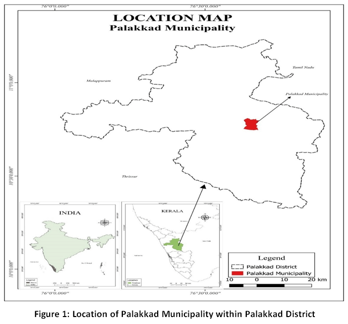 | Figure 1: Location of Palakkad Municipality within Palakkad District.
|
Materials and Methods
This study employs a multi-temporal spatial analysis approach to evaluate LULC changes due to urban sprawl in the Palakkad Municipality. Covering the years 2001, 2011, and 2021, the methodology integrates remote sensing systems with GISmodelling to classify, quantify, and map variations across different land cover types. Statistical and spatial analytical tools are used to assess the magnitude, direction, and urban growth pattern.19 At the same time, demographic and infrastructural data are integrated to interpret the socioeconomic drivers behind this sprawl. Furthermore, ground verification and field observations were used to assess the reliability of the classification results. Representative locations across different land-use categories were compared with available secondary data sources to verify classification accuracy. This cross-verification ensured that the identified spatial patterns correspond closely with actual ground conditions.
Data Sources and Materials
The analysis is based on a combination of primary and secondary data sources, with multi-temporal satellite imagery forming the foundation of the research. The Landsat series was chosen for its consistent temporal coverage, reliable spectral resolution, and compatibility with LULC mapping. The satellite data were sourced from the United States Geological Survey (USGS) EarthExplorerdatabase. Detailed specifications of the imagery used for this analysis are provided in Table 1.
Table 1: Specifications of Landsat Satellite Imagery Used for Spatial Analysis.
Satellite / Mission | Sensor / Instrument | Spatial Resolution (m) | Spectral Bands Used | Path / Row | Acquisition Year |
Landsat 7 | Enhanced Thematic Mapper Plus | 30 (Multispectral), 15 (Pan) | Bands 1–5, 7 (Visible, NIR, SWIR) | Path 144 / Row 053 | 2001 |
Landsat 7 | Enhanced Thematic Mapper Plus | 30 (Multispectral), 15 (Pan) | Bands 1–5, 7 (Visible, NIR, SWIR) | Path 144 / Row 053 | 2011 |
Landsat 8 | Operational Land Imager | 30 (Multispectral), 15 (Pan) | Bands 2–7 (Visible, NIR, SWIR) | Path 144 / Row 052 | 2021 |
Along with satellite imagery, demographic and planning datasets were included to link horizontal urban growth to population changes. These include:
Census of India (2001 and 2011): Population, workforce, and housing data drawn from the Primary Census Abstracts.
Survey Reports (2023): Field-based ground truth surveys and demographic validations.
Local Planning Records: Urban zoning and infrastructure data obtained from the Palakkad Municipal Office.
Pre-Processing and Classification Workflow
All satellite images underwent a rigorous pre-processing workflow prior to analysis. Radiometric and atmospheric corrections were applied to eliminate sensor-related noise and atmospheric distortions. The imagery was geometrically corrected to align with a common reference system (WGS 84, UTM Zone 43N). Following this, layer stacking and subsetting were performed to prepare uniform image extents corresponding exactly to the municipal boundaries of the study area.
A supervised classification approach based on the maximum likelihood algorithm was employed to classify the imagery into five primary land cover categories: built-up areas (settlements and infrastructure), mixed tree cover (vegetation and social forestry), net sown agricultural land, fallow land, and water bodies.The classification scheme broadly follows standard land-use and land-cover classification guidelines recommended by the National Remote Sensing Centre (NRSC), ensuring consistency and comparability of the classes.22Post-classification change detection was then performed to evaluate spatial transitions and calculate precise square-kilometre differences between classes across the three study years. Finally, spatial analyses, including overlay operations and zonal mapping, were carried out in the GIS environment to quantify urban expansion, identify growth corridors, and examine the underlying drivers of land transformation.
Results and Discussion
The urban sprawl and spatial growth of Palakkad Municipality can be understood through the Monocentric City Model, which suggests that urban development initially centres around a single core workplace. In Palakkad, early development was focused on the town centre, including the Municipal Office, Sulthanpet, Narikkuthy, and Pattikkara. During this phase, growth was fairly uniform, with a regular road network, resulting in a radial pattern of expansion. However, rapid population increase and strict vertical development restrictions eventually led to horizontal growth. This outward expansion became more uneven over time, primarily due to physical constraints and differing levels of accessibility.
Initially, urban development in the northwestern sector was limited by the Kalpathi River due to poor connectivity. To overcome this natural obstacle, significant infrastructural projects were undertaken, including the construction of bridges like the Puthiyapalam. The subsequent development of key institutions around Olavakkode Junction and Railway Station, such as Malabar Hospital, various cooperative colleges, and MES Higher Secondary School, spurred growth in this previously isolated area. Similarly, the southern municipal boundary, bordered by the Kannadi River, experienced growth mainly driven by road connectivity and access to essential services. Today, the most notable feature of Palakkad’s expansion is its linear pattern along major transport routes. Urban development has shifted beyond the central core and now extends actively along National Highway 213 and important state and district highways.
Visual interpretation of satellite imagery from 2001, 2011, and 2021 clearly shows the extent of this expansion. The total urban built-up area of Palakkad Municipality increased significantly, transforming the fringe areas such as Olavakkode Central and South, Valiyapadam, Thonipalayam, Kallepilly, Mankavu, Chirakkadu, Thirunellayi, Kallikkad, Pallipuram, and Meparamba, as detailed in Table 2.
Table 2: Decadal Changes in Total Urban Area Within Palakkad Municipality (2001–2021)
Year | Urban Area (Sq Km) | Urban Area (%) | Change in Area | Change in % |
2001 | 4.54 | 16.17 | Base Year | Base Year |
2011 | 6.04 | 21.52 | +1.50 Sq Km | +5.35% |
2021 | 14.25 | 50.80 | +8.21 Sq Km | +29.28% |
(Source: Census data & Computed by Researcher)
Changes in built-up area were examined over the study period to assess the extent of urban expansion. The built-up area increased from 16.17% in 2001 to 21.52% in 2011, and further to 50.80% in 2021. This indicates a relatively moderate increase during 2001–2011, followed by a rapid expansion during 2011–2021, highlighting a clear acceleration in urban sprawl.
Despite this outward sprawl, the historical core along the Shoranur-Coimbatore road remains the town's commercial heart. Sulthanpet Junction serves as a vital commercial node, highlighted by a 1.50 km stretch of diverse mixed-use developments. Planning for an expected 25 per cent increase in the urban population and a 150 per cent surge in floating population will necessitate careful redevelopment of areas like the Big Bazar to keep the urban core lively. Additionally, future planning should consider the rising influence of key institutions, including Olavakkode Railway station, Medical College, Malampuzha Dam, and IIT Palakkad, along with emerging urban centres such as Yakkara, Chandranagar, and Pirayiri.
To quantitatively evaluate these spatial transformations, change detection analysis was performed across five major LULC classes. The visual progression of these spatial changes, derived from supervised classification of Landsat imagery for 2001, 2011, and 2021, is shown in Figures 2, 3, and 4, respectively.
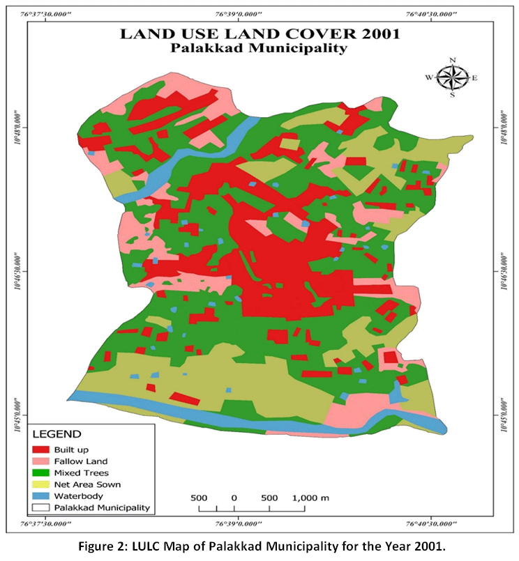 | Figure 2: LULC Map of Palakkad Municipality for the Year 2001.
|
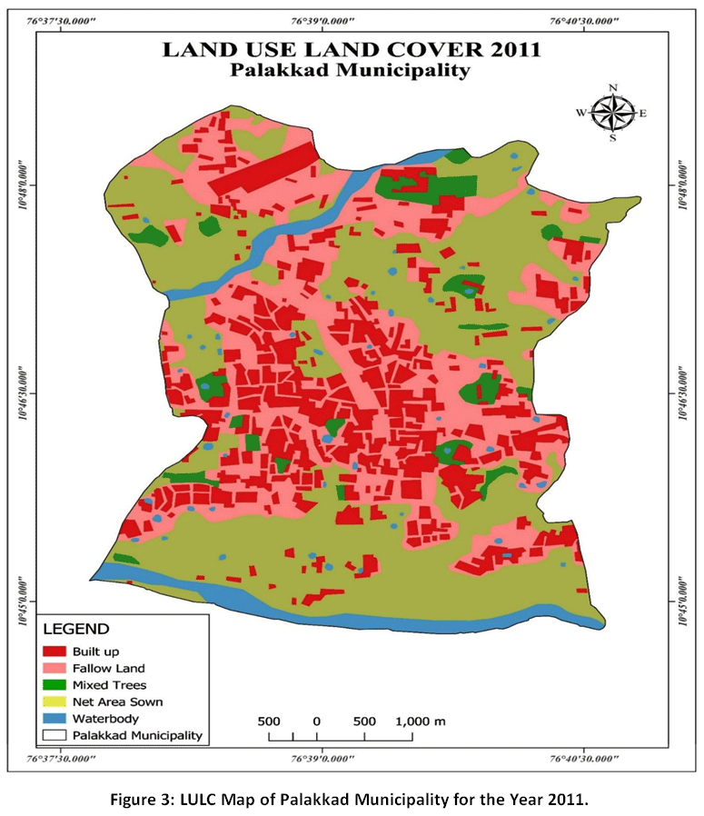 | Figure 3: LULC Map of Palakkad Municipality for the Year 2011.
|
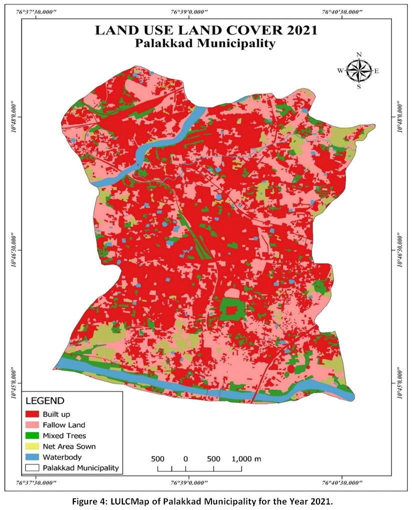 | Figure 4: LULCMap of Palakkad Municipality for the Year 2021.
|
The analysis highlights considerable variations in land distribution over the course of the study period,as detailed in Table 3. A visual distinction of these proportional changes is further illustrated in Figure 5.
Table 3: Spatiotemporal Changes in LULC Classes.
Land Use Class | 2001 (Sq Km) | 2001 (%) | 2011 (Sq Km) | 2011 (%) | 2021 (Sq Km) | 2021 (%) |
Built up | 4.54 | 16.17 | 6.04 | 21.52 | 14.25 | 50.80 |
Fallow Land | 6.52 | 23.22 | 7.48 | 26.65 | 8.25 | 29.39 |
Mixed Trees | 8.71 | 31.02 | 1.13 | 4.02 | 2.24 | 7.98 |
Net Area Sown | 6.52 | 23.22 | 11.80 | 42.04 | 1.74 | 6.20 |
Water Bodies | 1.79 | 6.37 | 1.62 | 5.77 | 1.58 | 5.63 |
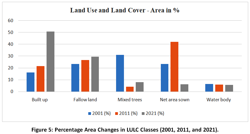 | Figure 5: Percentage Area Changes in LULC Classes (2001, 2011, and 2021).
|
The most significant finding is the rapid expansion of the built-up environment, including residential zones, commercial buildings, railway infrastructure, and institutional spaces, which by 2021 had covered more than half of the municipality (50.80 per cent). Conversely, the environment experienced notable degradation: the area covered by mixed trees (vegetation and social forestry) declined from 31.02 per cent in 2001 to just 7.98 per cent in 2021. Similarly, net sown agricultural land reduced sharply from 23.22 per cent to 6.20 per cent over the same period. The data clearly shows that the rapid growth of human settlements in Palakkad directly led to the conversion of agricultural lands and natural vegetation, resulting in fragmented landscapes. Additionally, the gradual rise in fallow land (from 23.22 per cent to 29.39 per cent) indicates an increase in uncultivated parcels left vacant around expanding construction zones.The LULC maps generated through classification were cross-verified using field observations and available secondary data sources, confirming the overall spatial patterns of built-up expansion and decline in vegetation and agricultural land.
The observed changes in LULC reflect the dynamic nature of urban transformation in rapidly developing medium-sized towns. In the context of Palakkad, agricultural lands often undergo transitional stages such as temporary fallow conditions before conversion into built-up areas, while vegetation and cultivated lands may vary due to seasonal practices and land management decisions. These temporal variations represent ongoing land-use conversion processes rather than isolated changes, and together they reinforce the broader trend of increasing urban expansion and declining productive and vegetated land.
The physical expansion of the city is closely connected to underlying demographic changes. Analysing demographic parameters offers essential context for the rising demand for urban land, as shown in Table 4.
Table 4: Demographic Characteristics and Urban Growth Indicators (2001–2021).
Year | Total Population | Total Workers | Main Workers | Population Change |
2001 | 130767 | 42932 | 39227 | Base Year |
2011 | 130955 | 45696 | 41011 | +188 (+0.14%) |
2021 | 135906 | 49809 | 43940 | +4951 (+3.78%) |
(Source: Census data & Computed by Researcher)
A deeper analysis of the demographic profile adds more context to this growth. According to the 2011 Census, Palakkad had a population of 130955, consisting of 63833 males and 67122 females, with children under six making up 9.30 per cent of the total. The female sex ratio was 1052, slightly below the state average of 1084, while the child sex ratio was 958. The overall literacy rate was 93.90 per cent, with male literacy at 96.54 per cent and female literacy at 91.42 per cent.
The administrative evolution of the municipality, which expanded from 50 to 53 wards between 2011 and 2023, reflects the complexities of managing rapid growth. Currently, the municipality is responsible for providing basic amenities, including water and sewerage, to over 31,176 houses. Furthermore, due to the postponement of the 2021 census, the current estimated population of Palakkad municipality in 2023 is approximately 180000. These combined spatial and demographic findings emphasise the urgent need to regulate unchecked sprawl and implement targeted urban planning frameworks to balance infrastructure development with environmental preservation.
The broader implications of these findings indicate that the current land transformation in Palakkad is ecologically unsustainable. Replacing permeable agricultural and vegetative surfaces with impermeable concrete not only threatens local food security but also changes the microclimate and natural water cycles. As the economy shifts and the number of workers increases, the demand for land will continue to push development into vulnerable fringe areas. Therefore, local policymakers must adopt smart growth strategies, focusing on vertical redevelopment of central areas and enforcing strict zoning laws to protect remaining green belts from irreversible urban spread.
The results contribute to a better understanding of urban sprawl dynamics in medium-sized municipalities in India. The observed pattern of corridor-based expansion driven by transportation networks and institutional growth is consistent with trends reported in several developing regions. However, the extent to which these findings can be extrapolated to other regions depends on variations in socio-economic conditions, planning regulations, and geographical constraints.
In contrast to large metropolitan regions or low-density suburban systems commonly observed in Western contexts, urban growth in smaller Indian cities often exhibits mixed-density and infrastructure-driven expansion patterns. Therefore, while the methodological framework of integrating remote sensing and GIS for spatiotemporal analysis is widely applicable, the specific growth patterns identified in Palakkad should be interpreted within its unique regional context.
Recent studies on spatial heterogeneity and scale effects emphasise that urban processes vary significantly across different spatial scales and local conditions. Hence, extrapolation of findings must consider differences in urban governance, land-use policies, and environmental settings. The results of this study are therefore most applicable to comparable medium-sized towns experiencing similar developmental pressures, rather than universally across all urban systems. These spatial patterns are consistent with theoretical models of urban expansion, particularly the transition from monocentric to corridor-based growth in emerging urban systems.
Conclusion
This study examines the spatial and temporal patterns of urban sprawl in Palakkad Municipality over a twenty-year period through the application of geospatial techniques. The results reveal a clear transformation in the urban structure, with a shift from a centralised growth pattern to pronounced linear expansion along major transportation corridors. The built-up area increased from 16.17% in 2001 to 50.80% in 2021, demonstrating the rapid conversion of land into urban use. This expansion has occurred largely at the expense of agricultural land and mixed tree vegetation, leading to fragmentation of natural landscapes and increasing ecological pressure within the municipality. The findings also indicate that demographic changes, particularly growth in population and workforce, have played a key role in driving this spatial expansion.
These patterns highlight the need for more targeted and context-specific urban planning strategies in medium-sized towns like Palakkad. Rather than continued outward expansion, planning efforts should focus on regulating corridor-based development, protecting remaining agricultural and vegetated areas, and improving land-use efficiency within the existing urban core. Strengthening zoning regulations, promoting controlled densification, and integrating geospatial monitoring into planning processes will be essential to manage future growth. Overall, the study highlights the need to balance infrastructure development with environmental conservation in order to support sustainable urban transformation in rapidly growing regional centres.
Acknowledgement
The authors would like to acknowledge that the present work has been carried out jointly by all three authors without any external collaboration. The authors sincerely thank all the open-access data sources and literature referenced in the manuscript for their valuable contributions to environmental research.
Funding Sources
The authors received no financial support for theresearch, authorship, and/or publication of thisarticle.
Conflict of Interest
The authors do not have any conflict of interest.
Data Availability Statement
The manuscript incorporates all datasets producedor examined throughout this research study.
Ethics Statement
This research did not involve human participants,animal subjects, or any material that requires ethicalapproval.
Informed Consent Statement
This study did not involve human participants, andtherefore, informed consent was not required.
Permission to reproduce material from other sources
Not Applicable
Author Contributions
Nazrin Begum Sardar: Conceptualization, Data Collection, Map Preparation.
Ameen Abdul Salam: Formal Analysis, Data Interpretation, Writing – Original Draft.
RoobinaAboobakker: Writing – Review & Editing, Validation.
References
- Sridhar MB, Sathyanathan R. Assessment of urban expansion and identification of sprawl through delineation of urban core boundary. J Landsc Ecol. 2022;15(3):102. doi:10.2478/jlecol-2022-0020.
CrossRef - Ashwathappa B, Maddikeari M, Das B, Vishweshwaraiah RT, Tangadagi RB. Urban sprawl analysis and LULC change assessment in Bengaluru rural, Karnataka, India. Research Square. 2022. doi:10.21203/rs.3.rs-1855333/v1.
CrossRef - Behnisch M, Krüger T, Jaeger JAG. Rapid rise in urban sprawl: global hotspots and trends since 1990. PLOS Sustain Transform. 2022;1(11). doi:10.1371/journal.pstr.0000034.
CrossRef - Malek M, Shahed MMH, Shabab KJ, Habib MA, Rashid MS. Monitoring urban growth and its impact on arable land consumption in the lower Turag basin of Dhaka: a Google Earth Engine based study. J GeogrInf Syst. 2024;16(6):418. doi:10.4236/jgis.2024.166024.
CrossRef - Ulloa-Espíndola R, Martín-Fernández S. Determining the areas most suitable for urban land use while minimizing impact on natural areas: the case of the Machachi Valley, Ecuador. Heliyon. 2024;10(17). doi:10.1016/j.heliyon.2024.e36596.
CrossRef - Chandel AS. Spatiotemporal urban sprawl analysis using geospatial techniques: a case of Bule Hora town, Ethiopia (1994–2024). Geocarto Int. 2025;40(1). doi:10.1080/10106049.2025.2561997.
CrossRef - Krishnaveni KS, Anilkumar PP. Managing urban sprawl using remote sensing and GIS. Int Arch Photogramm Remote Sens Spatial Inf Sci. 2020;59. doi:10.5194/isprs-archives-xlii-3-w11-59-2020.
CrossRef - Brown JF, Tollerud HJ, Barber CP, Zhou Q, Dwyer JL, Vogelmann JE, Loveland TR, Woodcock CE, Stehman SV, Zhu Z, Pengra BW, Smith K, Horton JA, Xian G, Auch RF, Sohl TL, Sayler KL, Gallant AL, Zelenak D, Reker RR, Rover J. Lessons learned implementing an operational continuous United States national land change monitoring capability: the Land Change Monitoring, Assessment, and Projection (LCMAP) approach. Remote Sens Environ. 2020;238:111356. doi:10.1016/j.rse.2019.111356.
CrossRef - Gul S, Bibi T, Rahim S, Gul Y, Niaz A, Mumtaz S, Shedayi AA. Monitoring of land use and land cover changes using remote sensing and geographic information system. Research Square. 2022. doi:10.21203/rs.3.rs-1721904/v1.
CrossRef - Kumar M, Singh RB, Pravesh R, Kumar P, Tripathi DK, Sahu N. Urban growth dynamics and modelling using remote sensing data and multivariate statistical techniques. Curr Sci. 2018;114(10):2080. doi:10.18520/cs/v114/i10/2080-2091.
CrossRef - Gehad TY, Omer NQ, Abdulmajeed NS. Methodology for using multi-temporal Landsat images to monitor urban growth of Kirkuk governorate. J Tech. 2024;6(2):71.
CrossRef - Mhangara P, Gidey E, Manjoo R. Analysis of urban sprawl dynamics using machine learning, CA-Markov chain, and the Shannon entropy model: a case study in Mbombela City, South Africa. Environ Syst Res. 2024;13(1). doi:10.1186/s40068-024-00348-5.
CrossRef - Nagappan SD, Daud SM. Machine learning predictors for sustainable urban planning. Int J AdvComputSci Appl. 2021;12(7). doi:10.14569/ijacsa.2021.0120787.
CrossRef - Uhl J, Leyk S, Li Z, Duan W, Shbita B, Chiang Y, Knoblock CA. Combining remote-sensing-derived data and historical maps for long-term back-casting of urban extents. Remote Sens. 2021;13(18):3672. doi:10.3390/rs13183672.
CrossRef - Lal CSP, Nair SB. Urbanization in Kerala—what does the census data reveal? Indian J Hum Dev. 2017;11(3):356-386.
CrossRef - Shamai A, Ghalehteimouri KJ. Land use evaluation and capacity assessment for sustainable urban physical development: case of study Ahvaz city. City Territ Archit. 2024;11(1):18. doi:10.1186/s40410-024-00239-3.
CrossRef - Viswambharan S, Kumaramkandath IT, Scaria R, et al. Interlinking land use change, carbon emissions, and surface temperature in the Palakkad Gap of Western Ghats: insights for climate resilience and sustainability. Earth Syst Environ. 2026. doi:10.1007/s41748-025-00985-5
CrossRef - Varada VK, SreeramaNaik SR, Vishwambaran S, Balakrishnan P. Impact of urban growth on landuse and land cover change. A case study of PudusserriGramapanchayat in Palakkad Gap using geospatial techniques. Geogr Anal. 2022;11(1):33-38. doi:10.53989/bu.ga.v11i1.22.7
- Fenta AA, Yasuda H, Haregeweyn N, et al. The dynamics of urban expansion and land use/land cover changes using remote sensing and spatial metrics: the case of Mekelle City of northern Ethiopia. Int J Remote Sens. 2017;38(14):4107-4129. doi:10.1080/01431161.2017.1317936
CrossRef - Ndugah H, Ramirez-Avila J. Socio-economic dynamics and land use/cover changes within Nairobi and Ruiru catchments in Kenya. Open Access Libr J. 2025;12(9):1-19. doi:10.4236/oalib.1114005
CrossRef - Aneesa S, Arathi N, Geetha A. Urban liquid waste management: bane to boon-a study of Palakkad town in Kerala. IOP Conf Ser: Mater Sci Eng. 2021;1114(1):012044. doi:10.1088/1757-899X/1114/1/012044
CrossRef - National Remote Sensing Centre. Land Use / Land Cover Analysis: Third Cycle Technical Document. Hyderabad, India: Indian Space Research Organisation, Department of Space, Government of India; 2012


