Underground Cavities Investigation Using Geophysical Method, GPR (Case Study: Kerman City)
Fatemehossadat Mirhosseini1 * , Mehdi Momeni1 and Ehsan Shafiei1
1
Department of Water Eng.,
Islamic Azad University,
Kerman branch,
Kerman
Iran
http://dx.doi.org/10.12944/CWE.10.Special-Issue1.12
One of the most important parameters in performance of every constructing project is the analysis of undersurface condition to assure the land fitness for structure establishment. Flumes and cavities in low depths can be specified fairly by GPR method due to obvious difference in electromagnetic characteristics with their surrounding environment. Geo radar studies have been used to explore undersurface phenomena such as flumes and cavities in Abolfazl Tekieh foundation site in Mahdieh Street, Kerman city. The aim of these studies is undersurface exploration of the depth of 3 to 15 m. The region under study was marked and profiled and all measurements were performed on determined profiles. After processing and expounding of removed sections according to obtained radar grams, some abnormalities were observed that mainly showed some undersurface looseness or small local cavities
Copy the following to cite this article:
Mirhosseini F, Momeni M, Shafiei E. Underground Cavities Investigation Using Geophysical Method, GPR (Case Study: Kerman City). Special Issue of Curr World Environ 2015;10(Special Issue May 2015). DOI:http://dx.doi.org/10.12944/CWE.10.Special-Issue1.12
Copy the following to cite this URL:
Mirhosseini F, Momeni M, Shafiei E. Underground Cavities Investigation Using Geophysical Method, GPR (Case Study: Kerman City). Special Issue of Curr World Environ 2015;10(Special Issue May 2015). Available from: http://www.cwejournal.org/?p=10503
Download article (pdf) Citation Manager Publish History
Introduction
One of the existing problems in construction matter and expansion of urban regions is the outbreak of innumerous ruptures in ground surface. This phenomenon that is mainly associated with ground subsidence, in geotechnical engineering is known as land subsidence. The phenomenon of ground subsidence and rupture has
been observed in different regions of the world. For primary study of the subsidence and rupture phenomenon, three general geotechnical elements could be considered as follows:
- Subsidence as a result of underground water extraction.
- Subsidence as a result of erosion and water washing in unstable soils.
- Subsidence as a result of ground diffusion in karst piles and creation of cavities.6
Therefore, one of the most important parameters in performance of every constructing project is the analysis of undersurface condition to assure the land fitness for structure establishment. In many buildings, it has been observed that after building establishment due to lack of surveys on suitable undersurface conditions , we have been encountered with building subsidence phenomenon, while if undersurface conditions were studied carefully before building constitution, we wouldn’t encountered with such a phenomenon.2
The evidences show that there are many flumes in Kerman city. The aim of this study is the identification of existing flumes and cavities using geo radar method in under study region. The principles and bases of the theory of geo radar method are very similar to echoic seismology.3 The wave used in seismology method is mechanical and of acoustic waves type but in GPR high frequency electromagnetic waves are used. Geo radar is used to locate undersurface phenomenon or lateral cohesion of common surface of soil and stone in low depths. In this method radio waves with high frequencies (between 10 to 3000 MH) are sent into ground and these waves mirror by striking with objects and or rather explicit boundary between underground layers and finally are recorded by a machine as mapping. Generally, processing of geophysical data is performed to dominate inherent limitations and noises existing in raw data. GPR method is not exempt from this rule and even in some studies achieving considered goals seems impossible without exerting suitable processes.3 The domain of utilized processes on data is controlled by different parameters. In some studies, even it is possible that the exertion of primary processes on data is withheld and in some of them an extensive domain of processes is performed on data. Usually, in the first stage, data is edited. In this stage, the amendment of zero time, converting of profiles direction, omission of repeated traces and their addition to stations where removal is done, the edition of removal parameters like central frequencies and antenna space are performed. Many studies are fulfilled in the field of regions undersurface identification using geophysical methods. Hamid Beygi and Rasekh (2014) used geophysical microgravity measurement methods and specific electrical resistance in determining flume route and concluded that combination of these two methods raises the identification accuracy.2 Mahmoudi et al (2014) identified flume routes in Afzali poor university in Kerman using long distance measurement studies and finally recognized flumes stems.7 BaniAsadi (2007) used GPR method for revealing stone properties and discontinuity.1 Mohammadi vizheh and Kamkar Rouhani (2011) used GPR method for revealing undersurface graved structures and introduced specific resistance method a very good complement for GPR.8 Nick var Hasani (2013) mentioned GPR method as a compatible method with the environment and rapid in identification of karst cavities in Razi University in Kermanshah region.10 Nasseri et al in a study introduced GPR method and also its very positive effect on flume route detection.9
Materials and Methods
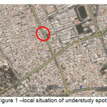
The mentioned project is performed in Kerman city and in order to assessment of the location of Abolfazl Tekieh construction placed in Mahdieh Street in the corner of 15 and 17 alleys. This province is placed geographically between 53 degree and 26 minutes to 59 degree and 29 minutes of eastern length and 25 degree and 55 minutes to 32 degree northern width. Kerman city, the center of Kerman province, is placed geographically in 57 degree and 7 minutes of eastern length and 30 degree and 18 minutes northern width and in the height of 1755 m from sea level. The present project is Abolfazl Tekieh foundation in Mahdieh Street in the corner of 15 and 17 alleys. This structure is a concrete frame of 7 stores, two stores are cellars.
 |
|
Collected data were processed by geo radar. Ground-penetrating radar (GPR) is a technique of imaging the subsurface at high resolution. Although analogous in some ways to the seismic methods. GPR is a non-destructive technique and can consequently be applied in urban and sensitive environments. GPR has many geological applications, such as imaging shallow soil and rock structure at high resolution, locating buried channels and mapping the water table. It also has several non-geological uses such as in archaeology, for the location of buried walls or cavities, and in forensic investigations, for the location of recently-disturbed ground where a burial has taken place. GPR is similar in its principles to seismic reflection profiling and sonar surveying. Radar velocities are controlled by the dielectric constant(relative permittivity) and conductivity of the subsurface Dielectric permittivity does not usually vary by more than a factor of 10 in most natural materials, so it is the more highly variable resistivity that controls the depth of penetration of a radar pulse. Generally, depth of penetration increases with increasing resistivity. Penetration is of the order of 20 m, although this may increase to 50 m under optimal conditions of low conductivity. As with seismic waves, there is a trade-off between depth of penetration and resolution, with the greater penetration achieved with the lower frequencies. The depth of penetration of radio waves depends on their frequency and the nature of the material being surveyed. The permittivity of water is high compared to dry materials, so the water content and porosity are important controls on penetration4
Utilized equipment for measuring undersurface condition by geo radar mainly includes transmitter antennas, radar controlling unit and suitable tools for data storage and processing. Part of wave's energy is reflected striking with undersurface common terms or is scattered and part of it penetrates in layers or graved objects. The electrical component of electromagnetic waves (E) is recorded by receptor as a time scale function. The receptor may have the ability to store and digitizing data. Some advanced systems are associated with a computer that makes possible data process at removal time and after that. Electromagnetic waves reflection (mirroring) and fracture is accomplished in common terms between layers and objectives which are different in electrical characteristics. Di electrical passing (É›) and electrical conduction (Éš) are determining physical parameters in wave's reflectiveness from common terms.5
Since geophysical methods are based on materials physical characteristics and the identification element is the difference between physical parameters of material and environment, changes are considered according to these points and are known and analyzed as abnormality. The abnormalities that are considered in this study are related to flume route and possible cavities. All observed changes in processed radar grams are shown with curve mark. The picture of radar grams is presented here as the result of processing. The removal route in every site is determined according to environmental conditions. Removed profiles for understudy range are scanned by MH antenna. The position of identified phenomena relating to each removal is determined on related radar gram so that its geometric position can be easily extracted. Considering of this range is due to possible measurement error and lateral disjunction strength. The strength space of depth disjunction (fourth wave length) also can be considered for the depth of identified phenomenon. That is the depth of phenomenon presence can rarely be determined as a number. But one fourth of wave length can be considered as its changes range. The average wave length of electromagnetic waves in available materials in understudy range is 150 cm for 50 MH antennas. For example, for identified pipe by 50 MH antenna in 5 m of depth, it can be suggested that the mentioned phenomenon in the depth space of 6/4 to 4/5 m is possible.
In this site, a number of 12 profiles in 6 lines geo radar removal in a sweep form are performed. The situation of removed lines is shown in figure 2. 12 removed profiles by 50 MH antennas have been done in understudy region.
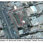 |
Fig. 2: situation of removed lines in Abolfazl Tekieh foundation site Click here to View figure |
Results
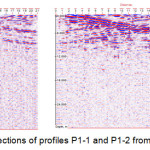
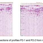
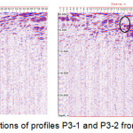
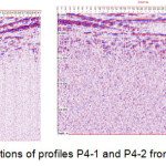
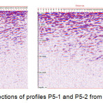
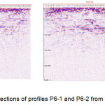
The results of removed sections are presented in figures 3 to 9. In the sections of removal line of profiles number P1-1 in the direction of eastern western, P2-1 in approximate direction of northern southern and P2-2 in the reverse direction of point P2-1, any special phenomena or abnormality is seen in these profiles. In the section of removal line number P1-2 which is removed reverse to section P1-1 two cases of abnormalities in the spaces of 5/3 and 11 m in depths of 3 and 5/5 m can be seen. In the section of removal line number P3-1 which is removed in approximate direction of northern southern, there is an abnormality in the space of 20 m and depth of 2 to 4 m. removal line section number P3-2 is removed reverse to P3-1 section. An abnormality in the space of 21 m and depth of 2 to 4 m of this removal line is seen. Removal line section of P4-1 is removed from ramp. An abnormality is seen in the space of 32 m and depth 3 m. in sections number P4-2 which is in reverse direction of section P4-1von ramp , number P5-1 that is inside the alley in northern side of site location , number P5-2 in reverse direction of section P5-1 , number P6-1 that is inside the pavement of Abolfazl Tekieh foundation and P6-2 that is in reverse direction of P6-1 are removed and no considerable case can be seen in these sections.
 |
|
 |
|
 |
|
 |
|
 |
|
 |
|
After processing of removed sections and their analysis and interpretation based on obtained radar grams, some abnormalities were observed. Position and depth of every abnormality existing in each profile with abnormalities are presented in table 1.
Table1: Coordinates and anomalies depth in Abolfazl Tekieh foundation site
|
anomalies' depth(m) |
Coordinates of anomalies |
Profile Number |
number |
|
|
Latitude |
Longitude |
|||
|
3 |
3352641 |
507264 |
P1-2 |
1 |
|
5.5 |
3352639 |
507257 |
P1-2 |
2 |
|
3 |
3352652 |
507253 |
P3-1 |
3 |
|
3 |
3352650 |
507252 |
P3-2 |
4 |
|
3 |
3352659 |
507232 |
P4-1 |
5 |
Discussion
In this study, in order to identify undersurface phenomena like flumes and cavities in the site of Abolfazl Tekieh foundation in Mahdieh Street in Kerman city geo radar studies were used. The utilization of this geophysical method was done without destruction of related environment and damage to understudy regions soil and caused the acceleration of identifying trend. 12 removal lines were performed. After processing of removed sections and their analyzing and interpreting based on obtained radar grams, some abnormalities were observed. From total removed profiles, 5 profiles had abnormalities. With performed analyses, regarding that the observed abnormalities in the site of Abolfazl Tekieh foundation have no special and determined trend, then they cannot be assigned to the existence of flumes. But, the existence of these abnormalities mainly shows undersurface looseness or small local cavities. Therefore, more accurate studies and performance of necessary appliances for preventing from damages in future is essential. The Discussion should state the possibilities the results uncover, that need to be further explored. There is no need to include another title such as “Conclusions” at the end of Discussion. Results and discussion of results can also be combined under one section, Results and Discussion.
References
- BaniAsadi, A. Stability evaluation of tunnel using combined use of geophysical methods. Second Conference on confronting Natural Disaster. December, Tehran. Iran(2007).
- Hamid beygi, M.; Rasekh, P. Integrating Resistivity and Microgravity Data in Detection of Underground Canals-Amir Abad-Tehran. National Conference on Mineral Sciences. September, Mazandaran. Iran(2014).
- Hosseini, M. (GPR) in SHahroud area and compare results with the results of the geomagnetic in this area. Master's Thesis. Department of Mines and Geophysics. Technology University of Shahroud(2009).
- Kearey, PH.; Brooks,M.; Hill, I. An introduction to geophysical exploration. (Blackwell Science Ltd,2002).
- Knödel, K.; Lange, G.; Voigt, H.-J. (Eds.). Environmental Geology.(Handbook of Field Methods and Case Studies, Springer, ISBN 978-3-540-74669-0, Berlin,2007).
- Komakpanah, A. Studying causes of dissociation in roads of Yazd-Ardakan plain. Journal of transportation, 4(2), 181-196(2007).
- Mahmoudi, S.; Ranjbar, H.; Kariminasab, A. Underground cavities investigation using Remote sensing studies and GIS,case study: Campus of Shahid Bahonar Kerman University. 2nd National and Conference of Environmental Research. August, Hamedan, Iran(2014).
- Mohammadi Vizheh, M.; Kamkar Rouhani, A. Investigation of Near Surface Buried Structures Using GPR and Resistivity Methods: A Case Study. scientific quarterly journal, geoscience, 20(80),163-170(2011).
- Nasseri, A.; Mohammadzadeh fakhri, MJ.; Agababaie,H. The Qanats Exploitation And Ground Penetration Radar. International History Seminar on Irrigation and Drainage.May, Tehran.Iran(2007).
- Nick var Hasani, A. Use of geophysical methods in the study of seepage underground spaces. 9th students Conference of Mining Engineering. October, Birjand.Iran(2013).


